Data for tracking tropical cyclones
Data for Tracking Tropical Cyclones
LEE Man-chun
November 2019
The devastating scenes brought about by Super Typhoon Mangkhut during its passage in September 2018 were still vivid in our mind. Its accompanied damaging winds, heavy downpours, storm surge and high seas remind us of the power of nature. Whenever tropical cyclone season comes, weather forecasters will monitor closely the formation and development of tropical cyclones over the western North Pacific and the South China Sea, especially those possibly posing a threat to Hong Kong. As such, collecting and processing all tropical cyclone-related observational data and information is the first key step for tracking and forecasting tropical cyclones.
Weather is changeable, yet there are signs of its evolution. Noting the chaotic nature of weather systems, numerical weather prediction (NWP) models cannot produce accurate forecasts all the time, and sometimes the predictions can be very different from the actual situation. This makes weather observations even more important and valuable for monitoring purpose.
Over the vast ocean of the western North Pacific and the South China Sea, use of satellite observations is one of the tools that forecasters can rely on for estimating the location and intensity of a tropical cyclone. Physical quantities like sea surface temperatures and derived tropical cyclone heat potential can provide useful guidance to forecasters on the potential development of a tropical cyclone. Meanwhile, forecasters also make reference to other observational data acquired from various communication channels and stored in the meteorological database, including:
• Data via the Global Telecommunication System (GTS), such as
- Ship reports;
- Surface synoptic observations (SYNOP);
- Radar observations (RADOB);
- Tropical cyclone-related bulletins from different meteorological centres;
• Data from automatic weather stations in the territory and adjacent areas;
• Radar imagery;
• Drifting buoys; and
• Dropsonde system.
- Ship reports;
- Surface synoptic observations (SYNOP);
- Radar observations (RADOB);
- Tropical cyclone-related bulletins from different meteorological centres;
• Data from automatic weather stations in the territory and adjacent areas;
• Radar imagery;
• Drifting buoys; and
• Dropsonde system.
After consolidating various meteorological observational data and information, forecasters can analyse and monitor the development of a tropical cyclone on the in-house developed a GIS-based Integrated Meteorological Information Display (MET-GIS) platform. Together with the Intelligent Meteorological Monitoring Assistant (IMMA) system, forecasters are able to keep a close weather watch.
Monitoring is the first step in the forecast process. Next time, we will talk more on the forecasting techniques for tropical cyclones.
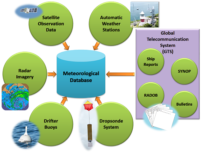
Figure 1 Schematic diagram showing observational data and information retrieved by the Observatory's meteorological database