Tracking by Radar Observations
Tracking by Radar Observations
CHAN Chik-cheung
September 2010
Tracking tropical cyclones using satellite pictures was discussed in a previous article. A similar approach can be used to locate the centre of a tropical cyclone if it comes within the tracking range of a weather radar. A weather radar detects rain in the atmosphere by emitting pulses of microwave and measuring the reflected signals from the raindrops. In general, the more intense the reflected signals, the higher will be the rain intensity. The distance of the rain is determined from the time it takes for the microwave to travel to and from the rain. Again, an eye on the radar screen is a clear indicator of where the tropical cyclone is (Figure 1). If an eye is absent, it is still possible to obtain a reasonable estimate of the centre by studying the relative motion of rain echoes near its centre (Figure 2). Different radars have different effective ranges for detecting tropical cyclones depending on the wavelength, power, and the height of the location of the radar antenna. For Hong Kong, the centre of a tropical cyclone can normally be tracked on the radar if it is located within 500 kilometres of the territory.
Doppler weather radar has become increasingly popular in recent years. Apart from rain intensity, it is also capable of measuring the approach (or departing) speed of raindrops, commonly called the radial speed. The principle is that the faster the raindrops move towards the radar, the higher will be the frequency of the microwave reflected from raindrops. The raindrops' approach speed is a good estimation of the winds which carry the raindrops. For a tropical cyclone, the radial speed is zero (i.e. the raindrop is neither moving towards nor away from the radar) along the line joining the centre of the cyclone and the radar (Figure 3). This line is called the zero isodop. As such, the centre of a tropical cyclone always lies on the zero isodop. In Figure 4, the white line is the zero isodop.
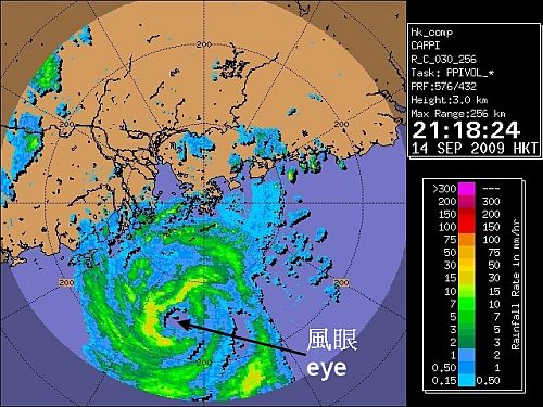
Figure 1 Radar imagery of Typhoon Koppu taken at 14 Sept 2009 21:18 HKT
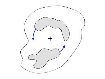
Figure 2 The relative motion of rain echoes around the centre of a tropical cyclone in Northern Hemisphere.
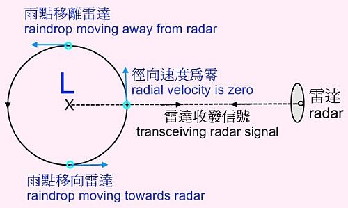
Figure 3 Radial velocity is zero along the line joining the centre of the tropical cyclone and the radar.
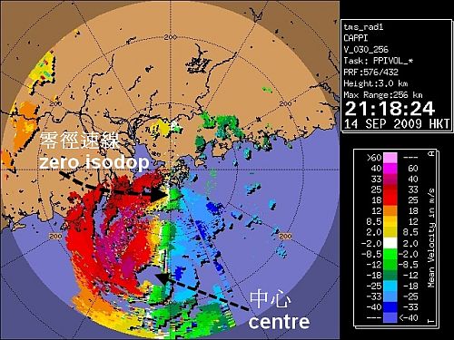
Figure 4 Radar imagery showing the Doppler winds of Typhoon Koppu taken at 14 Sept 2009 21:18 HKT