The use of Ship Reports in Determining the Intensity of a Tropical Cyclone
The use of Ship Reports in Determining the Intensity of a Tropical Cyclone
NG Moon-chiu
September 2011
The intensity of a tropical cyclone is determined by the strength of the surface winds near its centre. Amongst other meteorological observations, ship reports in the vicinity of a tropical cyclone are very important as they provide surface wind speed observations which are directly related to the intensity of the tropical cyclone. With the scarcity of direct surface wind speed observations especially over the oceans, analysis of remote sensing data collected by weather satellites for estimating tropical cyclone intensity has been extensively used since the availability of satellite imageries in late 1970's.
However, satellite imageries may not be helpful sometimes in estimation of tropical cyclone intensity, especially in the initial development phase of the tropical cyclone when the cloud feature has yet to be better organized. In these cases, ship reports in the vicinity of the tropical cyclone once again become most valuable in safeguarding the marine community. An example is given below.
On the early morning of 27 July 2004, a low pressure area over the South China Sea about 200 km east-southeast of Hong Kong was developing. Its development was closely monitored by the Hong Kong Observatory. Due to the poorly organized cloud feature, analysis of the satellite imagery at about 18 UTC on 26 July 2004 could not justify a tropical depression over the region (Figure 1). Fortunately, a ship nearby reported a strong wind of 29 knots in the vicinity of the low pressure area at almost the same time (Figure 2). Based on this ship report, the duty forecaster upgraded the low pressure area to a tropical depression (a tropical cyclone with maximum sustained wind speed of 22-33 knots near the centre) and issued the Tropical Cyclone Warning for Shipping to warn the shipping community about the storm.
Ship weather observations are made by Voluntary Observing Ships (VOS), which are merchant ships equipped with meteorological instruments. Ship officers on board make weather observations regularly and transmit them via satellite to meteorological centres during their voyages. Despite the advance in the satellite remote sensing technology, the weather observations taken by the VOS will continue to be vital to the safety of the shipping community over the oceans against hazardous weather phenomena.
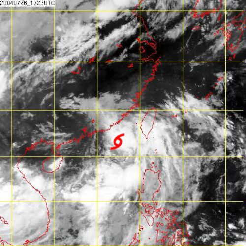
Figure 1. Infra-red satellite imagery at about 18 UTC on 26 July 2004. [The satellite imagery was originally captured by the Geostationary Operational Environmental Satellite-9 (GOES-9) of National Oceanic and Atmospheric Administration (NOAA).]
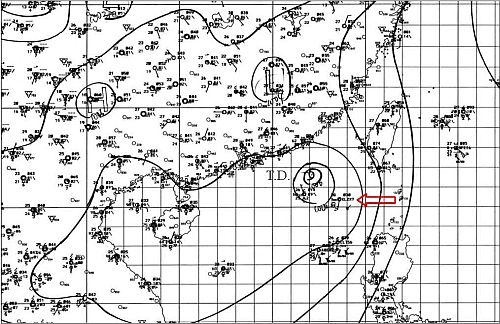
Figure 2. Weather chart at 18 UTC on 26 July 2004. A strong wind of 29 knots was reported by a voluntary observing ship (as indicated) near the tropical depression.