Lupit, the Eastward-moving Storm
11 May 2022
CHONG Man-lok and CHOY Chun-wing
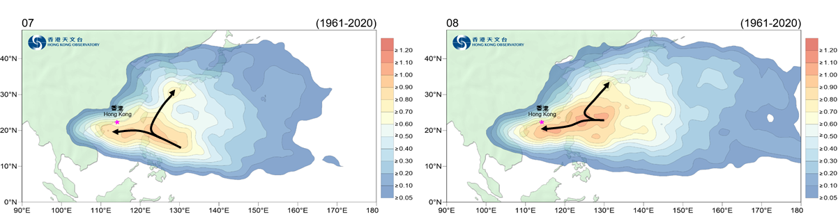
Hong Kong is affected by tropical cyclones from time to time in summer, many of which form over the western North Pacific and move westwards, entering the South China Sea through the Luzon Strait or the Philippines. In mid-summer months of July and August, tropical cyclones over the western North Pacific and the South China Sea usually adopt two major types of tracks (Figure 1): One moves west or northwest towards southern China or across the South China Sea; whereas the other recurves towards the mid-latitudes over the vicinity to the east of Taiwan and does not directly affect southern China or the South China Sea.
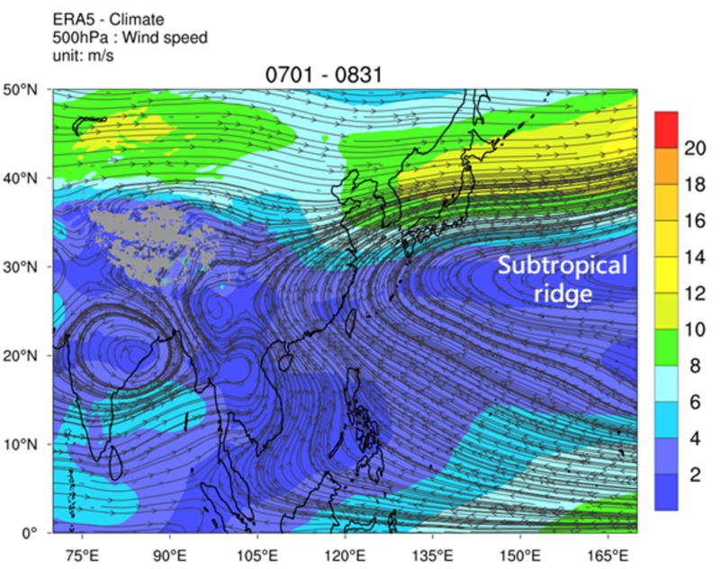
It can be seen from the climatological mean wind field at the 500-hPa level (altitude of around 5000 - 6000 m) (Figure 2) that, in mid-summer, an extensive anticyclonic circulation is covering most parts of the western North Pacific and southeastern China. This is known as “subtropical ridge”. The subtropical ridge is a deep and warm high pressure system with air sinking from aloft and becoming drier. Regions under its domination have relatively settled weather and fewer clouds. The ridge is also one of the substantial weather systems that steers tropical cyclone. When the ridge is stronger, it would extend westwards to southeastern China and even cover the entire southern China. Tropical cyclones would be steered by easterly winds along the southern flank of the subtropical ridge and track west or northwest. This accounts for the first type of tracks mentioned above.
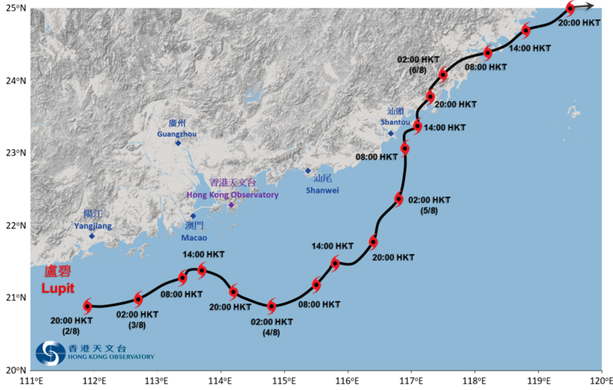
Lupit, the tropical cyclone that formed over offshore Yangjiang of Guangdong in early August of 2021, moved in an opposite direction from west to east across the northern part of the South China Sea. It skirted at about 110 kilometres south-southwest of Hong Kong and brought Strong Wind Signal, No. 3 to the city, making it a rare tropical cyclone that struck Hong Kong from the west (Figure 3).
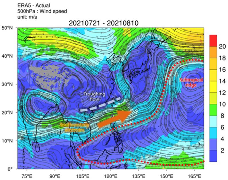
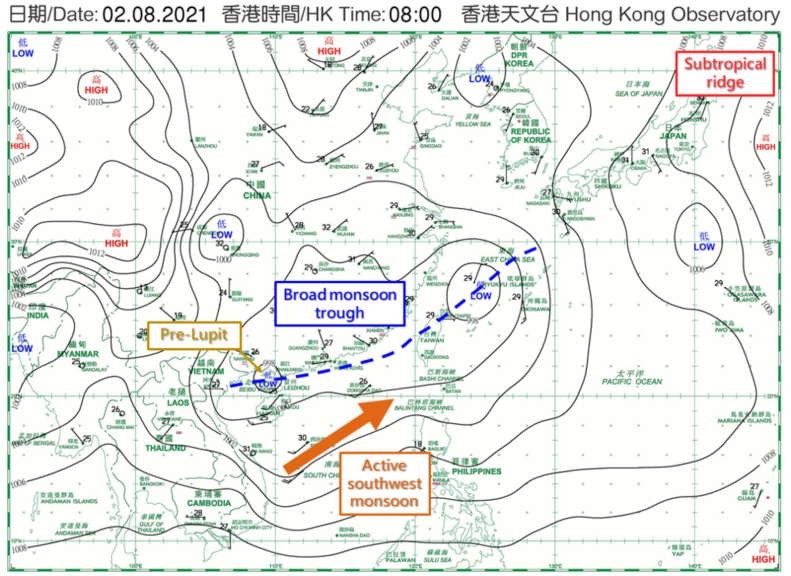
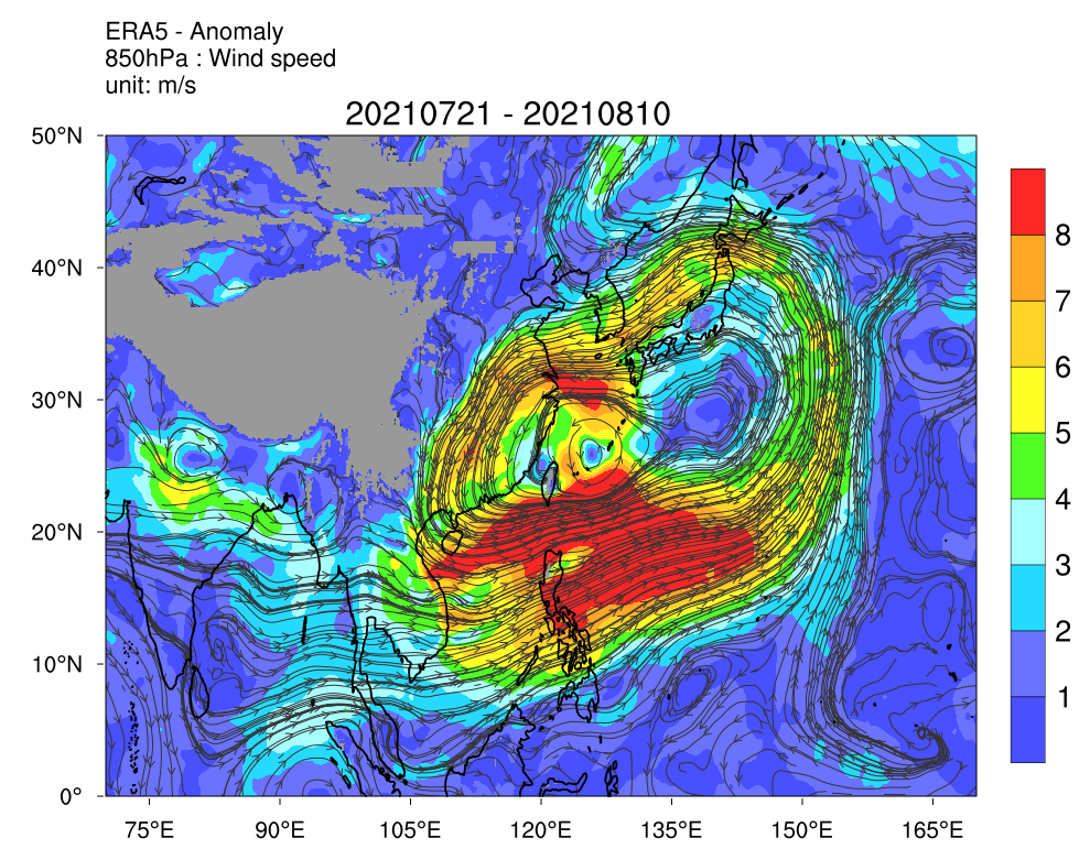
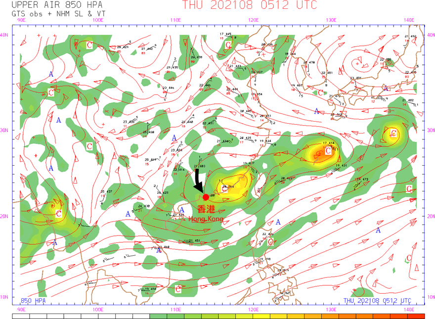
Comparing the climatological mean wind field at the 500-hPa level of July and August (Figure 2) and wind field of late July to early August in 2021 (Figure 4), it is apparent that the subtropical ridge did not cover southern China, but shifted southwards to the southern part of the South China Sea, and the northern part of the South China Sea was covered by southwesterly steering flow. If we also look at the surface weather chart on the morning of the day when Lupit formed (2 August 2021) (Figure 5), the axis of a broad monsoon trough extended from Beibu Wan all the way to the vicinity of the Ryukyu Islands, and the area of low pressure near Leizhou Peninsula was Lupit in its formative stage. Also, isobars to the south of the trough axis was rather packed, indicating that the southwest monsoon was rather active. Since there was lack of steering from the subtropical ridge and low-level southwesterlies were anomalously strong (Figure 6), Lupit was eventually steered by the southwesterly flow, moving generally east to northeastwards across the northern part of the South China Sea and then skirting the coastal areas of Fujian.
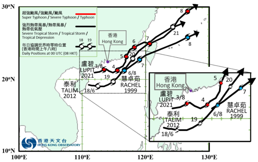
Although Lupit’s track was uncommon, there were still previous examples, e.g. Talim in June 2012 and Rachel in August 1999 also adopted tracks of the same type (Figure 7). Past information reveals that when both tropical cyclones were over the South China Sea, the atmospheric setting at mid to low levels were very similar to that of Lupit – the subtropical ridge did not cover southern China, and the southwest monsoon was rather active over the South China Sea. Unlike traditional westward-moving tropical cyclones, when eastward-moving cyclones skirt to the south of Hong Kong, Hong Kong would be located in its navigable semicircle, and as a result the threat of winds is relatively lower than their westward-moving counterparts. The closest approach of the two aforementioned tropical cyclones to Hong Kong were both around 250 kilometres, Rachel did not bring Hong Kong any Tropical Cyclone Warning Signal, and only up to Strong Wind Signal, No. 3 was issued for Talim. As Lupit tracked much closer to Hong Kong, did it pose greater threat to the city?
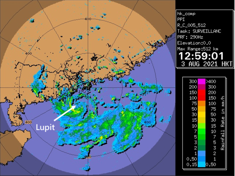
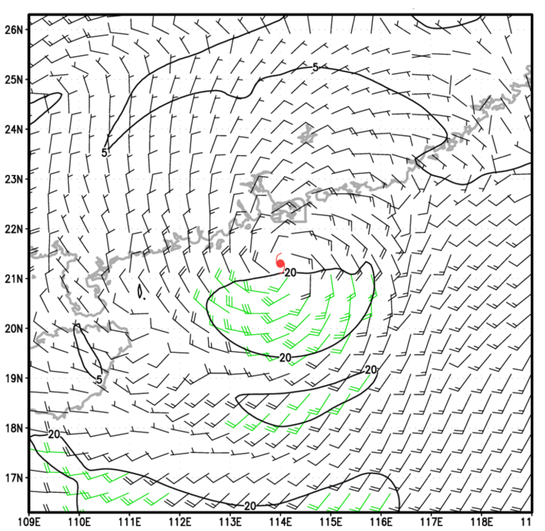
Lupit intensified from an area of low pressure into a tropical depression over offshore Yanjiang at 8 p.m. on 2 August 2021, and moved generally east-northeast overnight, edging closer to Hong Kong. Lupit took on a more northward track than model predictions on the morning of 3 August. It also slightly intensified during that period and therefore posed increased threat to Hong Kong. From the radar imagery at around 1 p.m. that day (Figure 8), Lupit had a rather compact circulation. Moisture from the southwest monsoon favoured convections over Lupit’s southern flank. Regarding the wind structure of Lupit (Figure 9), it was generally weaker over the northern semicircle with high winds distributed asymmetrically over the southern flank, attributable mainly to the southwest monsoon and semicircle effect combined. Given a TC at such proximity, forecasters must consider the following likely scenarios seriously: (i) Lupit may further intensify under relatively high sea surface temperature and low vertical wind shear conditions; and (ii) Lupit may track even closer to Hong Kong during the overnight period on 3 August 2021 due to wobbling by several tens of kilometres, a scale beyond the prediction capability of most forecast models. Since Lupit was very close to Hong Kong, either or both scenarios could lead to significant strengthening of local winds in Hong Kong. With this anticipation, the Strong Wind Signal, No. 3 was issued later in the afternoon on 3 August.
Fortunately, Lupit did not wobble further north and eventually tracked east to southeast across the seas south of Hong Kong. Lupit did intensify into a tropical storm but at a later time when it started to depart Hong Kong. As a result, local winds had not strengthened significantly. For compact tropical cyclones like Lupit, forecast models usually cannot accurately capture its track and intensity development; and Lupit’s asymmetric structure and atypical track also made statistical forecast tools such as “kidney” and “beach ball” less applicable. However, Lupit’s impact on Hong Kong was not limited to winds.
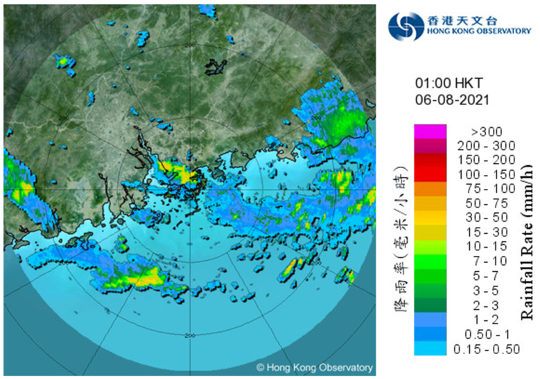
Despite Lupit began to depart Hong Kong at night on 4 August, its associated vorticity [Note 1] still covered Hong Kong in the following couple of days. Ample moisture and unstable atmosphere were also favourable conditions for convective activities. As Lupit moved to the east of Hong Kong, winds aloft changed from easterlies to northwesterlies (Figure 10). Since the sky was still relatively clear over inland Guangdong during the day, solar heating of the ground triggered convective activities. The areas of convective development edged towards the coastal areas following the cyclone’s circulation and affected Hong Kong overnight. These convections are normally referred as “evening thunderstorms”, although they are not necessarily confined to the evening. In the small hours of 5 and 6 August, Hong Kong was affected by showers originated from inland. The Observatory even once issued the Red Rainstorm Warning at 1:30 a.m., August 6 (Figure 11). In that morning, more than 30 millimetres of rainfall were recorded over many places, and rainfall even exceeded 100 millimetres near Sheung Shui and San Tin.
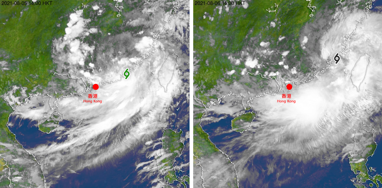
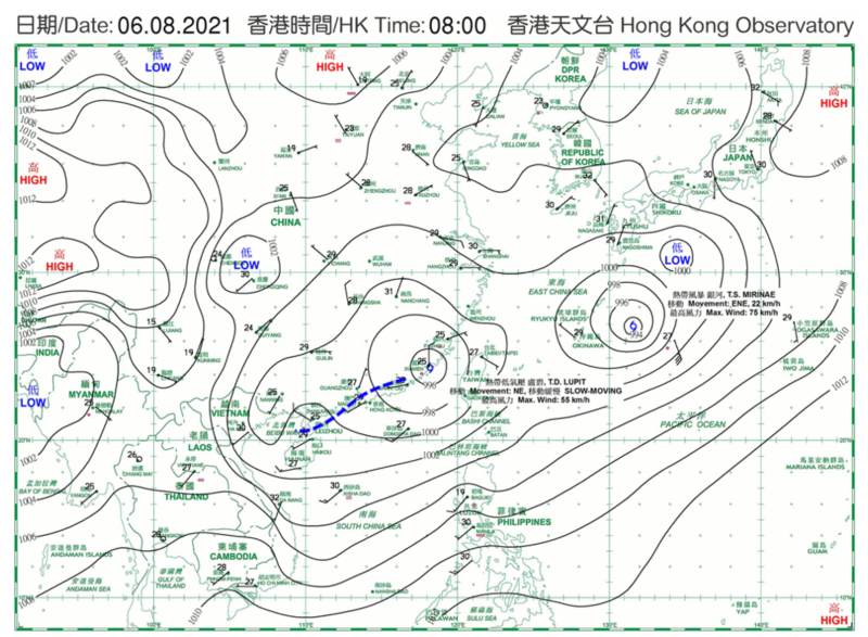
It is noteworthy that some tropical cyclones over the South China Sea would bring active southwest monsoon to the coast of southern China after they moved poleward, the intense and sustained convective activities may bring torrential rain to Hong Kong, an example was rain-related disasters in Po Hing Fong Disaster in 1925. This time, Lupit was also formed within an active monsoon trough, intense convections associated with the southwest monsoon sustained to the south of Lupit’s centre, which resembled a “tail” in satellite imagery (Figure 12). The tail eventually did not affect Hong Kong even when Lupit took on its northeast movement, but Hong Kong was affected by convections originated inland. Surface weather chart on the morning of 6 August (Figure 13) showed that the centre of Lupit already moved to the coast of Fujian, with Guangdong still remained in the broad monsoon trough. In fact, a weak trough could be analysed over the coastal areas as a result of convergence of continental airstream associated with Lupit and the southwest monsoon flow. The region of convergence has lifting mechanism for convective activities, but the area of active southwest monsoon (the area with tight isobars) still lied over the South China Sea. Hence the tail of Lupit affected mainly over the northern part of the South China Sea (Figure 12, right) and did not further advance northwards towards the coast. Lupit then tracked further away from Hong Kong and entered the East China Sea. The associated intense convection also moved away from the northern part of the South China Sea.
There are no identical tropical cyclones. Forecasters have to sustain the effort to analyse and learn from all cases of tropical cyclone, in particular special cases like Lupit, and strive to improve forecast techniques in respect of irregular movement, intensification and convective weather.
Note:
1. Vorticity is a physical quantity that describes rotation of fluid. A more positive vorticity signifies a stronger cyclonic circulation.