Radar Image Gallery: Storms and Precipitation
Storms and Precipitation
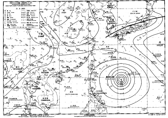 Fig.1 Weather Chart on 31 August 2003 |
A tropical cyclone far away can sometimes bring thunderstorms to Hong Kong. A case in point is Typhoon Dujuan. When Dujuan was still over the western Pacific at the end of August 2003 (Fig.1), most parts of southeastern China had clear skies because of the fine weather outside the storm. As a result of abundant sunshine, thunderstorms developed over the region during the day (Fig.2). Under the influence of northeasterly winds aloft associated with the circulation of the storm, the thunderstorms moved southwestward and affected Hong Kong that evening (Figs. 3 & 4). |
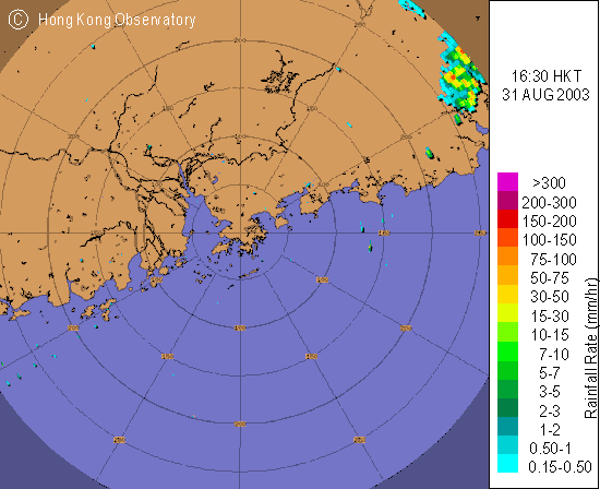 Fig.2 Radar image at 4:30 p.m. | |
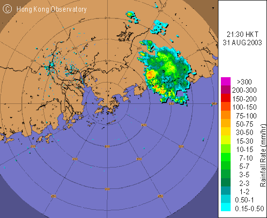 Fig.3 Radar image at 9:30 p.m. | |
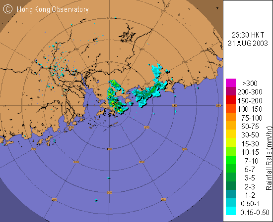 Fig.4 Radar image at 11:30 p.m. | |

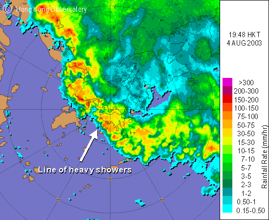 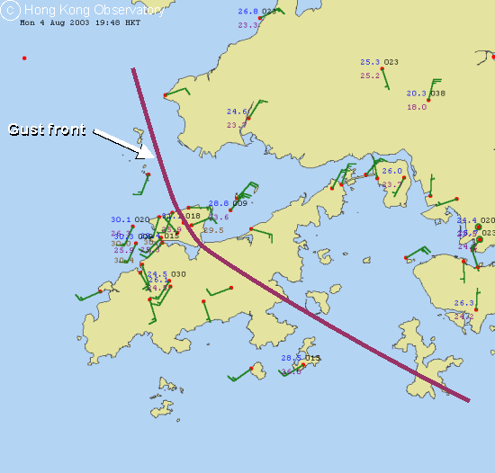 |
The radar image shows a line of heavy showers lying SE-NW over Hong Kong in a summer's evening. The lower figure shows the wind field close to the heavy showers at that time. The prevailing winds were southwesterlies then, as can be seen over western Lantau. However, the winds abruptly changed to northeasterlies over eastern Lantau. These were gusts arising from the heavy downpour (shown in the radar image). Gusts of up to 70 km/h were recorded at Chek Lap Kok that evening. The foremost edge of gusts is known as the gust front. |
|
|
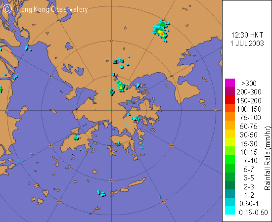
Isolated showers appear as small individual patches on a radar image. They sometimes can develop into very localized intense thunderstorms. It is not uncommon, especially during summertime, that localised parts of the territory are having heavy downpour while the other parts are enjoying abundant sunshine. It can be seen from the image that isolated showers were affecting Lantau, Sai Kung and the northern part of the New Territories. Can you see a much heavier shower further north? |
|
|
In winter, rain is usually brought about when warm and cold air masses meet. This is often known as frontal rain, which is typically wide in extent and uniform in intensity. The image shows a typical example of winter rain during which an intense cold surge arrived Hong Kong on 6 January 2003. It rained extensively and continuously over Guangdong. The temperature in Hong Kong dropped to 8.8 degrees during the day and a total rainfall of 16.5 mm was recorded on that day. |
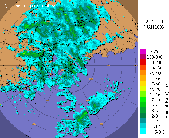
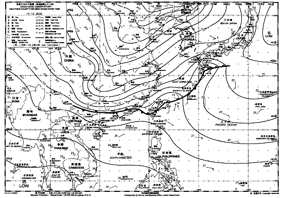 Fig.1 Weather Chart on 19 December 2002 |
A cold front can also bring thunderstorms during the cool season. On 19 December 2002, a cold front over inland Guangdong (Fig. 1) advanced southward. Ahead of the front, the air was relatively warm and moist. With the arrival of the front, the relatively warm air being less dense became lifted by the advancing cold air. The upward motion resulted in convection, eventually producing thunderstorms over the western coast of Guangdong, the New Territories and Lantau (Figs. 2 to 4). The occasion necessitated the issuance of the Thunderstorm Warning, the first time in the month of December since the introduction of the warning system in 1967. |
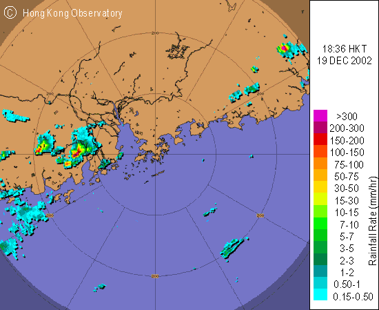 Fig.2 Radar image at 6:36 p.m. | |
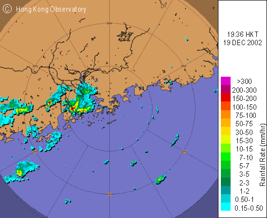 Fig.3 Radar image at 7:36 p.m. | |
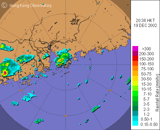 Fig.4 Radar image at 8:36 p.m. | |
|
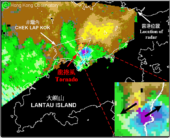
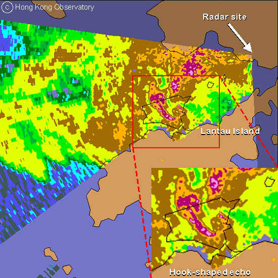
The terminal Doppler weather radar (TDWR) at Tai Lam Chung (12 km northeast of the airport at Chek Lap Kok) captured a tornado in May 2002 for the first time since its operation in 1998. The top image of Doppler velocity indicates opposing winds exceeding 90 kilometres per hour, affecting an area one kilometre across over the eastern part of Chek Lap Kok (inset). Purple/blue colored echoes represent winds blowing towards northeast, while orange/yellow colours indicate winds blowing towards the southwest. Two "bubbles" of opposing winds closely packed together is the typical pattern of a tornado. The bottom image of reflectivity (which provides estimation of the rain intensity) depicts the hook-shaped characteristic of the storm. This is another typical signature of tornado. A witness at the scene reported violent gusts, which caused some young trees to be toppled and dustbins and road signs blown around. |
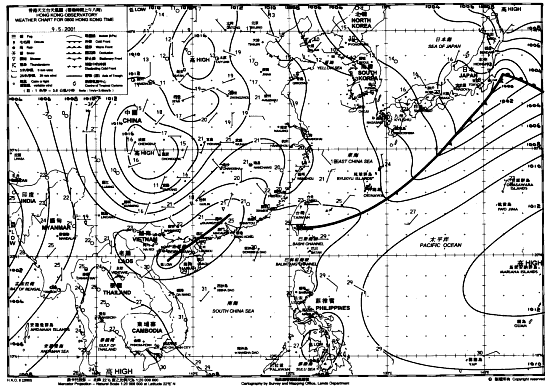 Fig.1 Weather Chart on 9 May 2001 |
The weather chart (Fig.1) indicates an active trough of low pressure lingering along the Guangdong coast that morning. The radar images (Figs. 2 & 3) show the approach of an intense squall line associated with this trough. Embedded in this line were squally thunderstorms that brought heavy rain to Hong Kong that afternoon. In Kwai Chung, about 50 containers were blown over in gusts. |
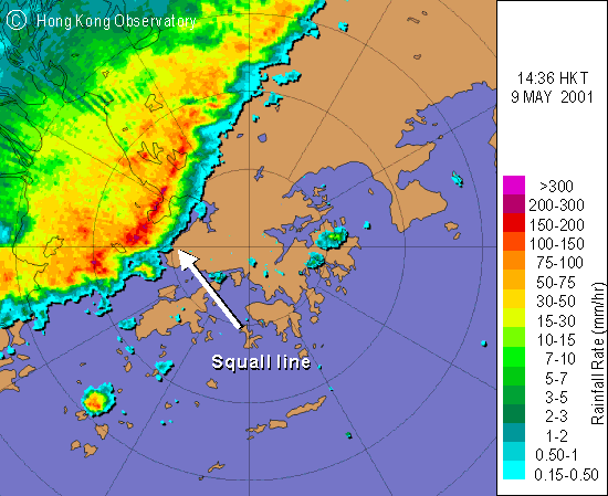 Fig.2 Radar image at 2:36 p.m. | |
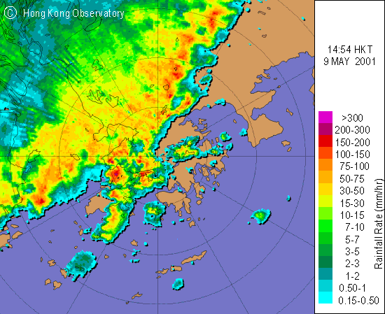 Fig.3 Radar image at 2:54 p.m. | |
|
|
Hail occurs on average about once every one to two years and mostly in spring. The radar image captures an active hailstorm near Tsing Yi in the afternoon of 9 April 2001. The subsequent southeastward movement of the hailstorm brought hailstones of diameter up to 2.5 cm to most parts of Kowloon later that afternoon. The inset is a vertical cross section of the hailstorm along points A and B. The very intense echoes (purple) are largely due to reflections from hailstones. |
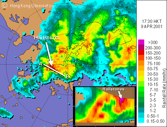
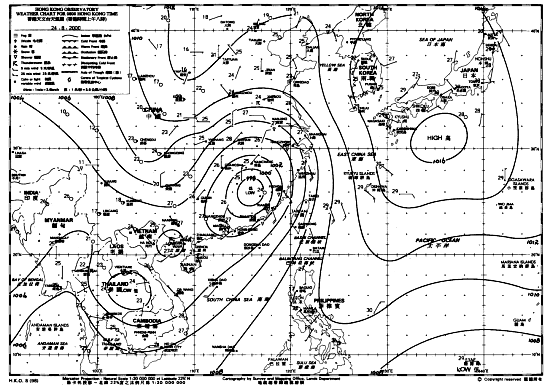 Fig.1 Weather Chart on 24 August 2000 |
A tropical cyclone can sometimes bring heavy rainfall even though it did not make a direct hit. In 2000, Typhoon Bilis weakened into a low-pressure area over southeastern China after landing. Meanwhile, an unstable southwesterly airstream set in over the coast of southern China (Fig. 1). The remnants of Bilis together with the southwesterlies brought heavy rain to the eastern coast of Guangdong and especially to Hong Kong (Figs. 2 & 3). Over 300 millimetres of rain were recorded in the southern part of Hong Kong Island in the early morning on 24 August 2000, thus necessitating the issuance of the Black Rainstorm Warning Signal. |
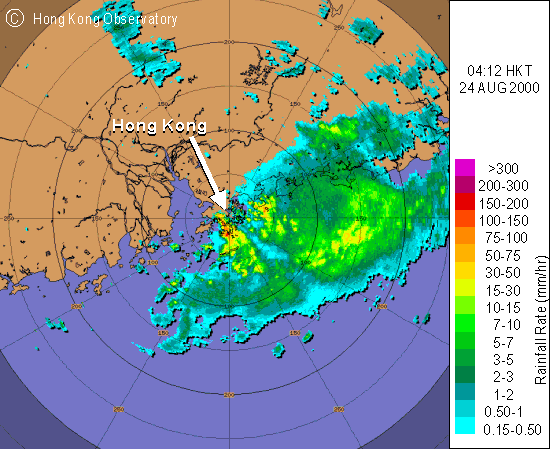 Fig.2 256-km range radar image at 4:12 a.m. | |
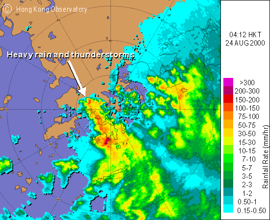 Fig.3 64-km range radar image at 4:12 a.m. | |