Orographic Rainfall in Hong Kong
Orographic Rainfall in Hong Kong
Wong Ho-yi, Ho Wai-hong
October 2024
In the previous article "Why is there More Rain in Tai Mo Shan?”, it was mentioned that there is significant difference in the mean annual rainfall across various districts in Hong Kong (Figure 1), with the highest value occurring near the highest peaks of the territory, such as Tai Mo Shan, Lantau Peak, Ma On Shan, Kowloon Peak, etc. The reason why regions near hills receive more rainfall is that when moist air masses encounter hilly terrain, they are forced to lift up. During the uplifting process, the air temperature decreases to the dew point temperature, causing water vapour to condense into raindrops, which in turn leads to formation of clouds and precipitation, and hence the occurrence of “orographic rainfall”. What conditions will favour the development of orographic rainfall and how to predict it?
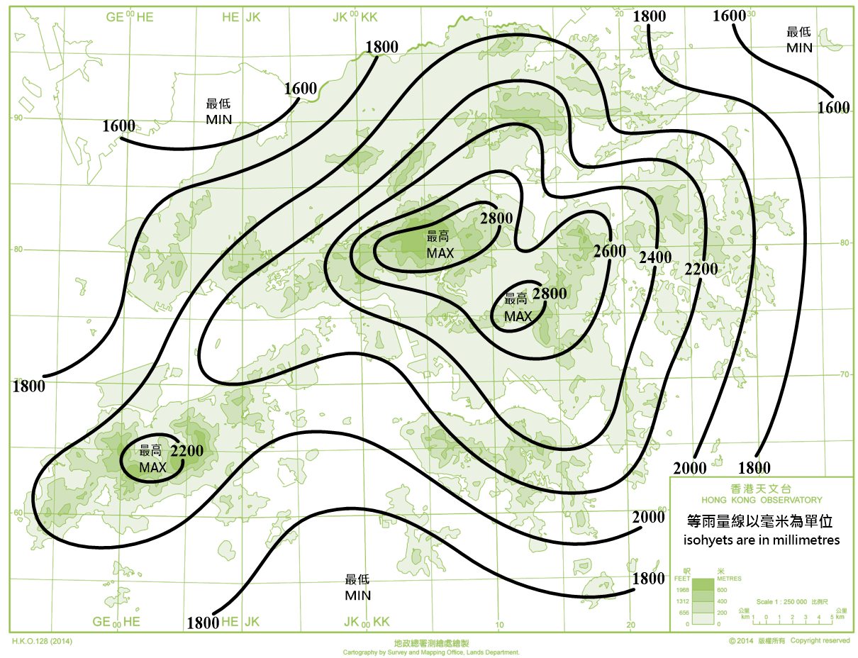
Figure 1 Mean annual rainfall over Hong Kong (1991-2020).
Examples of Orographic Rainfall
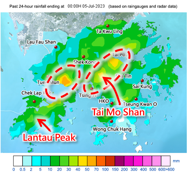
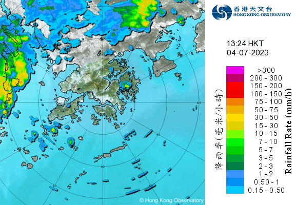
In Hong Kong, orographic rainfall is more common on days when winds blow from the southwest. For example, on July 4, 2023, under the influence of southwesterlies in Hong Kong, the radarscope (Figure 2) showed continuous development of rain areas near Tai Mo Shan starting from around 2 p.m. They moved in a southwest to northeast direction, with intensification observed downstream of Tai Mo Shan and Lantau Peak, resulting in increased rainfall over those areas. The episode lasted for approximately an hour. The daily rainfall chart for that day shows that there were significantly higher rainfall amounts over these regions compared to other places, reaching 40 millimeters or above.
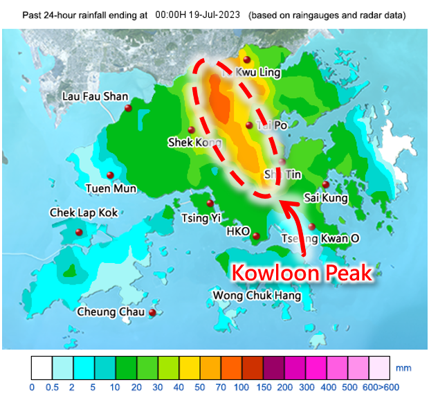
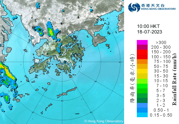
Having said that, orographic rainfall does not only occur on days with southwesterly winds. On July 18, 2023, under the influence of Tropical Cyclone Talim which was departing, relatively strong east to southeasterlies prevailed over the territory. Around 11 a.m. that day, rain areas started developing in the vicinity of Kowloon Peak (Figure 3) and moved northward due to low-level southerlies. The rain areas slightly intensified downstream of the hills, i.e. over the northern part of the New Territories. The episode lasted until around 1 p.m. From the rainfall distribution map for that day, it can be observed that there were higher rainfall amounts in the vicinity of Kowloon Peak and northern New Territories, with daily rainfall reaching 70 millimetres or more in some districts.
Forecast of Orographic Rainfall
While terrain favours the formation of rainfall, the rainfall distribution and duration of each event are different from each other. Sometimes, even on rainy days with southwesterly or southeasterly winds, the terrain effect may not be pronounced, and rainfall distribution across different districts may be more even compared to the cases mentioned above. It is often said that Hong Kong has a hilly terrain with limited areas of flat land. This makes the prediction of orographic rainfall an important topic for forecasters.
Numerical weather prediction models are currently the main tools used to assist weather forecasting. However, these computer models still have some limitations when it comes to predicting orographic rainfall. Firstly, although the spatial resolution of models continues to improve, with some models having a resolution of 10 km or even finer, Hong Kong’s small size and complex terrain present a challenge. Global models generally cannot fully capture the details of small-scale terrain, making it difficult to accurately simulate the impact of terrain on precipitation (Figure 4).
Numerical weather prediction models are currently the main tools used to assist weather forecasting. However, these computer models still have some limitations when it comes to predicting orographic rainfall. Firstly, although the spatial resolution of models continues to improve, with some models having a resolution of 10 km or even finer, Hong Kong’s small size and complex terrain present a challenge. Global models generally cannot fully capture the details of small-scale terrain, making it difficult to accurately simulate the impact of terrain on precipitation (Figure 4).
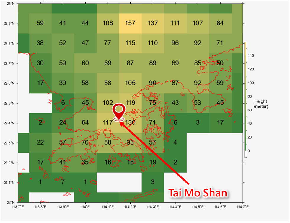
Figure 4 The height of each grid near Hong Kong in the European Centre for Medium-Range Weather Forecasts (ECMWF) model (horizontal resolution of approximately 9 kilometres). It can be seen that the model grid where Tai Mo Shan, which is about 1 kilometre high, is only slightly greater than 100 metres high in the model grid.
On the other hand, orographic rainfall involves numerous mesoscale and atmospheric boundary layer physical processes, such as cloud microphysics and boundary layer turbulence. However, these physical processes are still research topics in the scientific community, and there are still limitations in fully expressing related processes in numerical weather prediction models.
Therefore, accurate prediction of orographic rainfall cannot solely rely on numerical weather prediction models. Forecasters have to conduct in-depth analysis of the weather situation, assimilate various observational data, and assess whether atmospheric conditions are conducive to rainfall formation. Forecasters also have to pay particular attention to favourable conditions for orographic rainfall. Based on case studies and research on past significant orographic rainfall events in Hong Kong, when the lower atmosphere is influenced by sufficiently strong east to southeasterly winds or southwesterly winds, formation of significant orographic rainfall will be favourable. Under the influence of southwesterly winds, significant rainfall is more likely over the vicinity of the northeastern part of Lantau Island, Tai Mo Shan and the northeastern part of the New Territories. On the other hand, under east to southeasterly winds, rainfall is more pronounced over the eastern part of Hong Kong. Additionally, wind speed and the degree of atmospheric instability also affect the location and duration of convective activity as air flows over hills.
Although there are still limitations in numerical weather prediction models in forecasting the location and intensity of rainfall, we can utilize parameters that are relatively more well-predicted, such as wind speed and atmospheric instability, and combine model outputs of these parameters with the research results mentioned above, to develop products to assist forecasters in predicting orographic rainfall (Figure 5).
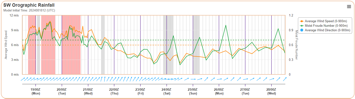
Figure 5 A tool based on forecast wind direction, wind speed, and the Moist Froude number (a parameter in fluid mechanics describing unstable atmospheric characteristics) from computer models to determine potential periods for orographic rainfall (highlighted in red) in the coming days.
Conclusions
Under suitable atmospheric conditions, orographic rainfall can cause rainfall significantly higher near hilly regions compared to flat areas. Forecasters assess the likelihood of orographic rainfall by carefully analyzing weather patterns and utilizing various forecasting tools. However, weather is constantly changing, and the timing and location of rainfall occurrences also exhibit a certain level of randomness. Therefore, when engaging in outdoor activities, especially hiking, it is essential to remain vigilant about changes in weather and to stay updated with the latest weather forecasts issued by the Observatory, along with notification messages from the "MyObservatory" mobile app.