Forecasting of Very Hot Weather
Forecasting of Very Hot Weather
HO Chun-kit
September 2020
In summer, the weather in Hong Kong is generally hot with an average daily maximum temperature of around 31 degrees Celsius in July and August. Temperatures can even be higher on days with fine weather. During the period of 2010 to 2019, there were generally more than 20 “very hot days” (with maximum temperature reaching 33.0 degrees Celsius or above) in a year recorded at the Hong Kong Observatory (HKO) headquarters, and the number of “very hot days” even exceeded 40 in 2020. Since very hot weather can increase the risk of heatstroke and may worsen chronic health conditions, high-temperature weather is one of the focus areas in weather forecasting in summer.
Hong Kong’s climate is sub-tropical, very hot weather in summer is usually associated with the subtropical ridge or the subsiding air at the periphery of a tropical cyclone at considerable distance from Hong Kong[1][2]. For the evolution of such relatively large-scale weather systems in the coming few days, computer weather prediction models are often able to provide reliable forecasts. Yet, it is still a challenge to forecast accurately the daily maximum temperatures in Hong Kong.
Figure 1 shows the variation of air temperatures at the HKO headquarters predicted by a few major computer weather prediction models on 15 July 2020 for the following ten days (purple, green and red lines). The actual recorded temperatures were also included and depicted as a black line in the figure for easy comparison with the model forecasts. It can be seen that the temperature predictions by computer models could be at least two or three degrees lower than the observations. One of the reasons is that the limited resolution of computer models cannot fully represent and simulate the effects of urbanization on air temperatures. In view of this, the Observatory adjusts the latest predictions of models based on their recent biases, and then uses a weighted average method according to the recent performance of each model to develop a temperature forecast guidance product for forecasters’ reference[3]. As compared with the predictions from individual computer models in Figure 1, in general this temperature forecast guidance (blue line) was found to be much closer to the actual observed values. Furthermore, forecasters will also make reference to the probability forecasts[4] and extreme weather forecast products[5] based on ensemble prediction systems to assess the likelihood of very hot weather in the coming few days.
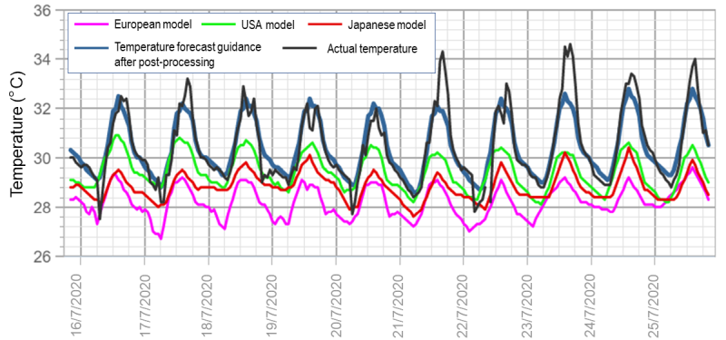
Figure 1. Variations of air temperatures at the HKO headquarters as predicted by major computer weather prediction models (purple, green and red lines) and using weighted average method (blue line) on 15 July 2020 for the following ten days as compared with the actual hourly observed temperatures (black line) during the period.
Apart from the evolution of large-scale weather systems, forecasters also need to consider other factors affecting air temperatures in forecasting very hot weather, and one of which is showers. In summer, when affected by the previously mentioned weather systems, the weather will be generally fine over southern China. However, if the atmospheric conditions are unstable, showers sometimes develop over the coastal areas and slightly mitigate the high temperatures. Generally speaking, under southerly or southwesterly winds, showers often occur in the morning, while in light wind conditions, showers triggered by high temperatures often develop after midday. Yet there is considerable randomness as to when and where the showers actually develop on each day. As a result, the temperature variation in different parts of Hong Kong may not be the same.
Figure 2 shows the daily rainfall distribution in Hong Kong and the maximum air temperatures from 15 to 23 July 2020. During the period, the local weather was mainly fine under the dominance of the subtropical ridge, but isolated showers also affected the territory. On days when the urban areas were affected by showers (such as 16 and 20 July), the maximum air temperatures recorded at the Observatory were slightly lower compared to the other days. As for 21 July, although there were showers over the northern part of the New Territories, the urban areas were not affected by showers and the temperature at the HKO headquarters climbed to around 35 degrees Celsius. With current technology, computer models are unable to capture the detailed temporal and spatial evolution of these showers and their impacts on temperatures at individual locations. As such, on some days there were still discrepancies between the actual temperatures and the model forecasts even after adjustments were made based on past biases (Figure 1).
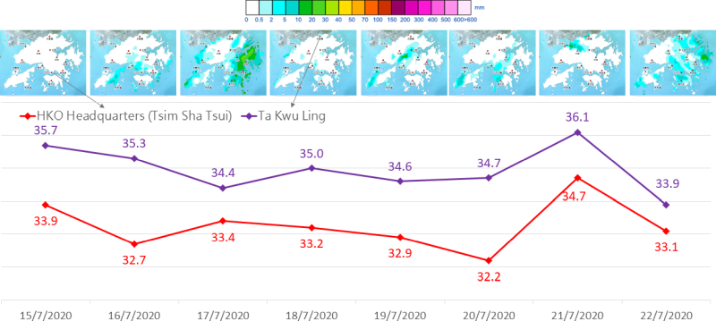
Figure 2. Distribution of rainfall over Hong Kong (top) and the daily maximum temperature (in degrees Celsius, bottom) at the HKO headquarters and Ta Kwu Ling from 15 to 22 July 2020.
Hong Kong is located at the south China coast, and winds are another factor affecting the maximum temperatures at various parts of the territory. As temperature rises more slowly over the sea than over land, sea breeze brought by such temperature difference helps slow down the rate of increase in temperatures over land. This explains why daytime air temperatures over the New Territories are typically higher than those in the urban areas closer to the coast (Figure 2). However, when winds are weak, temperatures over land cannot be effectively moderated by sea breeze, often resulting in a larger temperature difference between the New Territories and the urban areas. Figure 3 shows the daytime wind conditions and the maximum air temperatures on 24 June and 24 July 2020. Although there was prolonged sunshine on both days, there were slightly stronger southwesterlies on 24 June. Temperatures over the New Territories were only a couple of degrees higher than those in the urban areas. In contrast, on 24 July when winds were weaker, temperatures reached 37 degrees Celsius over the northern part of the New Territories, which were higher than those in the urban areas by three degrees or more.
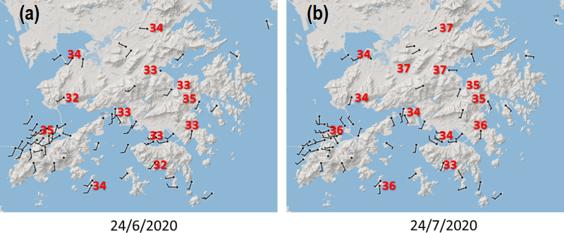
Figure 3. The maximum air temperatures (in degrees Celsius, numbers highlighted in red) and the wind direction and wind speed (black wind barbs) at 11 a.m. on (a) 24 June 2020; and (b) 24 July 2020.
In conclusion, even though computer weather prediction models can broadly capture the temperature trend in the coming few days, forecasting very hot weather, especially the spatial variations of temperatures in different regions, requires forecasters’ skilful analysis of various factors affecting the maximum temperatures. Under the influence of global warming and urbanization effect, the occurrence of very hot weather is expected to become more and more frequent in the future. On hot summer days, please pay attention to the information issued by the Observatory regarding high temperatures, in particular the Hot Weather Special Advisory and the Very Hot Weather Warning [6], and take corresponding measures against potential health impacts.
Extended reading:
[1] A chat of very hot weather
[2] Very Hot Weather Ahead of an Approaching Tropical Cyclone
[3] Objective Consensus Forecast: A site-specific multi-model consensus forecast in the Hong Kong Observatory
[4] Temperature trend at fingertips
[5] Forecasting extreme weather
[6] Knowing more about Very Hot Weather Warning