Tropical cyclone forecast systems at the Observatory
Tropical cyclone forecast systems at the Observatory
HO Chun-kit
October 2022
Whenever a tropical cyclone may pose a threat to Hong Kong, forecasters at the Observatory will closely monitor and analyse its movement and development round the clock and assess its potential impacts to the territory. The related monitoring and forecasting work involves a large amount of meteorological data and forecasting tools. In 2000, the Observatory developed a “Tropical Cyclone Information Processing System” (TIPS) which makes use of Geographical Information System (GIS) technology to integrate and display such information on a single platform, supporting analysis and decision-making by forecasters. In view of ever-increasing amount and type of weather information, a new-generation TIPS was put into operation in 2022. This article will give an overview on how weather forecasters make use of different types of information and tools to perform analysis and forecasting of storms.
Tropical cyclone analysis
To forecast the future movement and development of a tropical cyclone, one must first have a good grasp of its latest location and intensity. As observation data over the ocean are severely limited, forecasters usually determine the location of the tropical cyclone centre by identifying the associated spiral cloud bands or rain bands from satellite or radar imageries. Although satellite and radar information could also help analyse the intensity of a tropical cyclone, such information is not as detailed as observations made on the ground or over the seas. Apart from routinely receiving observation data and ship reports from around the world via the Global Telecommunication System, the Hong Kong Observatory also, under collaboration with the Guangdong Meteorological Service and the State Oceanic Administration, obtains observation data from automatic weather stations in real-time. The latter are particularly helpful in assessing the intensity change and location of tropical cyclones approaching the south China coast.
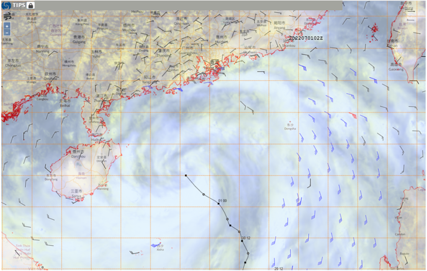
On TIPS, forecasters are able to display the above information on a digital map simultaneously, as well as to overlay the tropical cyclone track, so that a thorough assessment of the latest storm development can be made (Figure 1).

Figure 1 Wind observations from land-based stations and ships, as well as satellite-based derived wind fields on 1 July 2022 as Tropical Cyclone Chaba approached the south China coast (black line depicts the track of Chaba)
Tropical cyclone track forecasts
With the advancement of numerical weather prediction technology, the overall accuracy of tropical cyclone track forecasts has improved in recent years. However, various global computer models differ in their spatial resolution and how atmospheric physical processes are simulated. These, together with inherent uncertainties in the evolution of weather systems, different computer models sometimes predict significantly different tracks for the same tropical cyclone. As with other meteorological centres in the region, the Observatory makes reference to products from multiple computer models when forecasting tropical cyclone tracks.
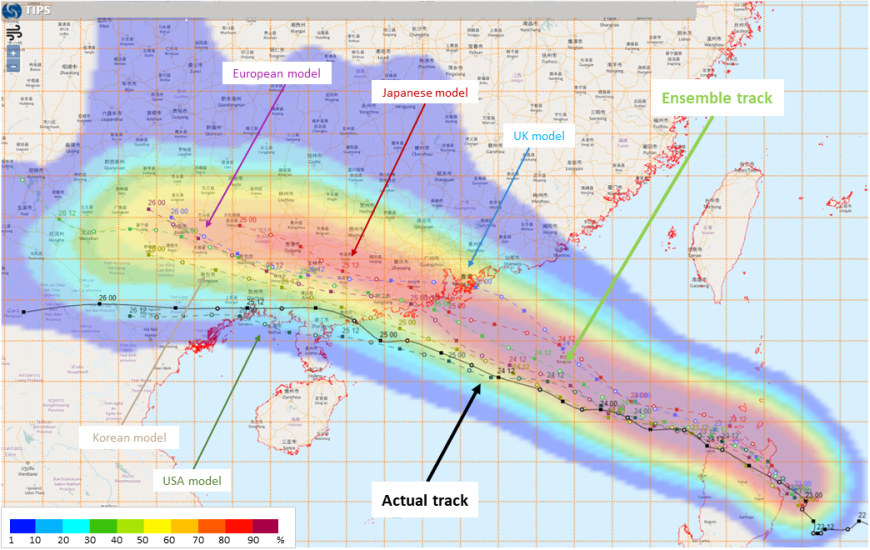
TIPS will automatically collect and process tropical cyclone track forecasts for major computer models from around the world, as well as warning bulletins from meteorological centres in the region. Forecast storm tracks by different models and meteorological centres are then displayed on a map to facilitate easy comparison by forecasters. The system also supports the calculation of an “ensemble track” based on multiple computer models using a weighted-average approach. Forecasters will make reference to this “ensemble track”, other computer model products (such as track probability forecasts) and observation data to prepare the tropical cyclone forecast tracks to be published on the Observatory website and mobile app.

Figure 2 Forecast tracks of Tropical Cyclone Ma-on by major global computer models on 23 August 2022. While most models suggested that Ma-on would move towards the coast of western Guangdong, discrepancies existed regarding the landfall location. Forecasters will make reference to the “ensemble track” (light green line) and probability forecasts (coloured areas, with reddish colours indicating a higher chance of the centre of the tropical cyclone passing near the location) when preparing the forecast track.
Assessment of local weather impacts
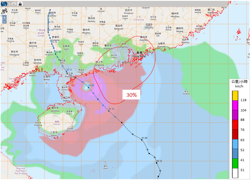
After formulating the forecast track, forecasters then need to assess whether and when high winds associated with the tropical cyclone will affect Hong Kong, which are important in deciding whether and when tropical cyclone warning signals are to be issued. In the past, forecasters have mostly referred to forecasting tools (known as “kidneys” by forecasters) developed based on statistics of past tropical cyclones affecting the territory, yet such tools have their limitations, for example they may not reflect high winds brought by the combined effects of a tropical cyclone and other weather systems. Hence, besides such tools, TIPS also provides overlay of wind speed forecasts from computer models, which serve as additional reference information to forecasters. With the above information, together with actual wind speed data over Hong Kong and neighbouring places, forecasters can more effectively estimate when local winds will pick up.

Figure 3 The forecast track of Tropical Cyclone Chaba (blue line) in the afternoon of 1 July 2022. Chaba was expected to skirt outside the “kidney” (red curved line) of 30% chance of gale force winds at the harbour, which means that the likelihood of gales in the harbour is relatively low based on historical cases. Meanwhile, the computer model predicted that gales associated with Chaba (the red area of the background layer) would affect parts of Hong Kong and the Pearl River Estuary.
Apart from high winds, forecasters also need to pay attention to the rise in water level caused by storm surges. Another function of TIPS is to provide forecast track information to the Observatory’s storm surge prediction system, which computes the changes in water levels at different locations. Forecasters will then issue alerts to public and relevant government departments according to the system outputs.
Conclusions
Analysing and forecasting tropical cyclones are an enormous challenge. Apart from keeping a close eye on all available observation information, forecasters need to continuously analyse forecasts from computer models and to assess the impacts of the storm to Hong Kong by applying forecasting tools and their experience, so that forecasts and warnings can be issued in a timely manner. The “Tropical Cyclone Information Processing System” (TIPS) is therefore an important tool in tropical cyclone operations at the Observatory. With more and more meteorological observation and forecast data, the development team will continue to enhance TIPS so that it could better support forecasters.