Considerations when selecting a site for tide gauge station
Considerations when selecting a site for tide gauge station
CHAN Yan-chun, LI Luen-on and TSE Shuk-mei
January 2021
Continuous and accurate monitoring of tide level is essential for predicting the astronomical tide level [1], monitoring storm surge [2] and tsunami. It is also irreplaceable when studying long-term sea level change. Moreover, tide data are used by mariners, coastal engineers, ferry operators, anglers and the general public for planning their activities. Last time, we introduced how to measure tide level [3]. Apart from having a calibrated instrument, a good site is also important for accurate measurement of tide level. Which of the following you would consider as a potential site of tide gauge station?
A. Bay with complicated terrain
B. Area subjected to erosion or with soft soil
C. River estuary or drainage outlet
D. Area with frequent marine activity or easy to accumulate marine debris
A. Bay with complicated terrain
B. Area subjected to erosion or with soft soil
C. River estuary or drainage outlet
D. Area with frequent marine activity or easy to accumulate marine debris
A. Bay with complicated terrain
Theoretically the water surface level is the same at any location in a tank of still water. However, the fact is that sea is not stationary. Tidal current and meteorological conditions [4] such as wind and atmospheric pressure make the sea level changing over time and with locations. The temporal and spatial variations will be more significant if the terrain is complicated. On the contrary, a site with good exposure to sea allows the measured tide and the predicted astronomical tide to be a good representative measurement of the area and its vicinity. For example, the tide gauge stations in Quarry Bay and Tai Po Kau can well represent the conditions in Victoria Harbour and Tolo Harbour respectively.
Theoretically the water surface level is the same at any location in a tank of still water. However, the fact is that sea is not stationary. Tidal current and meteorological conditions [4] such as wind and atmospheric pressure make the sea level changing over time and with locations. The temporal and spatial variations will be more significant if the terrain is complicated. On the contrary, a site with good exposure to sea allows the measured tide and the predicted astronomical tide to be a good representative measurement of the area and its vicinity. For example, the tide gauge stations in Quarry Bay and Tai Po Kau can well represent the conditions in Victoria Harbour and Tolo Harbour respectively.
B. Area subjected to erosion or with soft soil
If the tide gauge station is built in an area subjected to erosion or above soft soil, the instrument may subside or tilt slowly, which will affect the accuracy of the tide level measurement. Impact due to minor and gradual settlement can be corrected by monitoring the settlement of the station regularly. If there is a geodetic reference station nearby, the reference level of the tide gauge station could be calibrated by performing land survey regularly. Nevertheless, setting up a station on solid rock is highly preferred.
If the tide gauge station is built in an area subjected to erosion or above soft soil, the instrument may subside or tilt slowly, which will affect the accuracy of the tide level measurement. Impact due to minor and gradual settlement can be corrected by monitoring the settlement of the station regularly. If there is a geodetic reference station nearby, the reference level of the tide gauge station could be calibrated by performing land survey regularly. Nevertheless, setting up a station on solid rock is highly preferred.
C. River estuary or drainage outlet
In the event of heavy rain, rainwater will flow downstream along rivers or via surface runoff to the catchment. The water level near the catchment may fluctuate rapidly. Similarly, outflow of drains will pose similar undesirable impact. Moreover, the difference between rainwater and sea water density can possibly affect the accuracy of the measurement of certain tide gauge instruments.
In the event of heavy rain, rainwater will flow downstream along rivers or via surface runoff to the catchment. The water level near the catchment may fluctuate rapidly. Similarly, outflow of drains will pose similar undesirable impact. Moreover, the difference between rainwater and sea water density can possibly affect the accuracy of the measurement of certain tide gauge instruments.
D. Area with frequent marine activity or easy to accumulate marine debris
Vessels may induce large sea level oscillations. For instrument making use of the reflection of sound wave or radio wave to measure tide level, any boats or marine debris beneath the instrument will result in incorrect data. Besides, propeller turbulence and the marine debris can damage the instrument. The frequency of repairs and maintenance of the instrument will then increase accordingly.
Vessels may induce large sea level oscillations. For instrument making use of the reflection of sound wave or radio wave to measure tide level, any boats or marine debris beneath the instrument will result in incorrect data. Besides, propeller turbulence and the marine debris can damage the instrument. The frequency of repairs and maintenance of the instrument will then increase accordingly.
So the correct answer is none of the above. Apart from those factors mentioned above, factors like availability of electricity and data communication facilities, protection against damage by sea wave and extreme weather, adequate means of access for installation and maintenance, etc. also need to be considered. Thus it is not easy to find a good site for tide measurement. In reality, due to a number of site constraints, it is very often not possible to find a perfect site. Hence, it is very important to preserve a good and representative site.
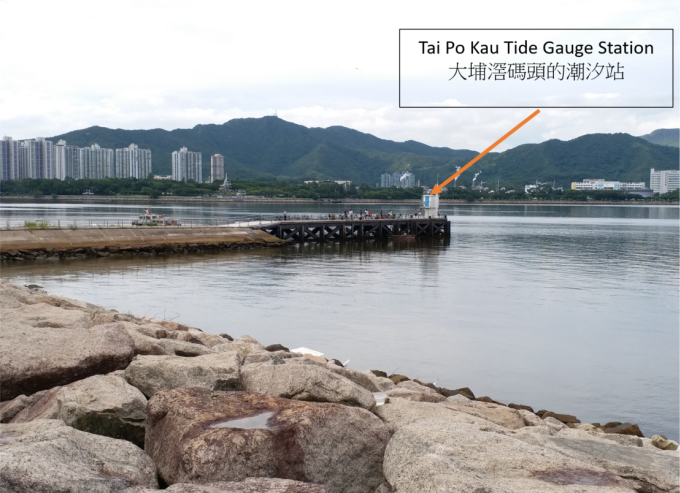
Figure 1 The mechanical component connected to an old type of tide gauge.
References:
[1] More on Tides
[2] Know More about Storm Surge
[3] How to measure tide level and storm surge
[4] Know more about Tides
[1] More on Tides
[2] Know More about Storm Surge
[3] How to measure tide level and storm surge
[4] Know more about Tides