Know More about Storm Surge
Know More about Storm Surge
NG Moon-chiu
September 2014
What is storm surge?
Storm surge is a rise of sea level due to the combined effects of low atmospheric pressure and high winds associated with tropical cyclones. Water is primarily being pushed towards the shore and piled up against the coast by the force of high winds associated with tropical cyclones (Figure 1).
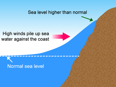
Figure 1 Effect of high winds
Low pressure at the centre of tropical cyclones also has the effect of enhancing the magnitude of a storm surge. As pressure is relatively higher around the periphery of a tropical cyclone, it tends to push down on the sea water outside and sucks up water near the cyclone centre (Figure 2).
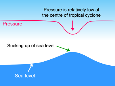
Figure 2 Effect of low pressure
Storm surge is the sea level rise generated by a tropical cyclone over and above the astronomical tide and does not have a reference level. Storm tide is the sea level during a tropical cyclone due to the combination of storm surge and astronomical tide (Figure 3). Like mean sea level, storm tide requires a reference level. In Hong Kong, the reference level is called "Chart Datum" (please see "Terminology" below), determined by the Survey and Mapping Office of Lands Department.
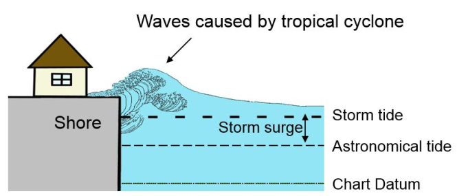
Figure 3 Relationship between Storm Tide and Storm Surge
When storm surge occurs during astronomical high tide, the storm tide can get very high, and low-lying areas may be flooded. In general, if the storm tide in the Victoria Harbour is 3 metres above Chart Datum or higher, flooding may occur in the low-lying areas of Hong Kong.
Major factors affecting storm surge
There are several factors that determine the storm surge generated by a tropical cyclone at a given location, including cyclone size and intensity, the direction of cyclone motion relative to the coast, and the shape of the coastline. A storm surge model is often used to simulate the effects of these factors.
Cyclone size
Winds in a larger tropical cyclone (usually expressed in terms of radius of maximum winds) are pushing on a more extensive area of the ocean. Strong winds in a larger tropical cyclone also tend to affect an area for a longer period of time. For tropical cyclones passing to the south of Hong Kong (Figure 4(a)), storm surge at the Victoria Harbour generated by a tropical cyclone of minimum central pressure of 980 hPa with a radius of maximum winds of 100 km would be higher than that generated by a tropical cyclone of the same minimum central pressure but with a smaller radius of maximum winds of only 50 km (Figure 4(b)) as shown in the model simulation results.
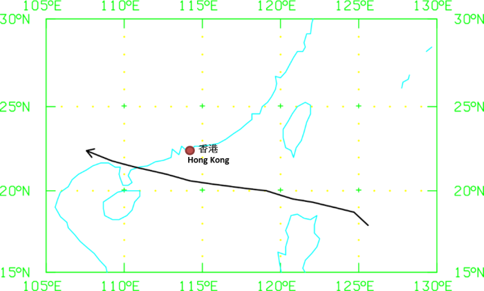
Figure 4(a) Typical track of a tropical cyclone passing to the south of Hong Kong
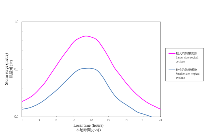
Figure 4(b) Model-simulated storm surges at the Victoria Harbour generated by tropical cyclones (minimum central pressure of 980 hPa) with a radius of maximum winds of 100 km (red) and 50 km (blue) passing to the south of Hong Kong on a track as shown in Figure 4(a).
Cyclone intensity
Lower central pressure (stronger winds) will produce a larger storm surge. Along the track shown in Figure 4 (a), model-simulated storm surges at the Victoria Harbour generated by a tropical cyclone with a radius of maximum winds of 50 km and a minimum central pressure of 920 hPa would be higher than that generated by a tropical cyclone of the same size but with a higher minimum central pressure of 980 hPa (Figure 5).
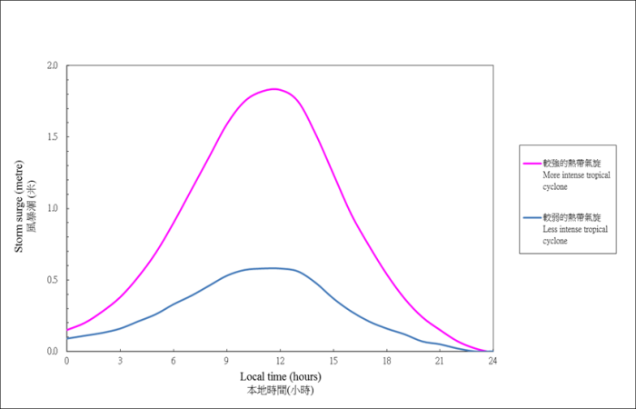
Figure 5 Model-simulated storm surges at the Victoria Harbour generated by a tropical cyclone passing to the south of Hong Kong along a track shown in Figure 4(a) with the same radius of maximum winds of 50 km, but with different minimum central pressure of 920 hPa (red) and 980 hPa (blue).
Direction of approach in cyclone motion
An approaching tropical cyclone bringing on-shore winds to the coast will generate a larger storm surge than a tropical cyclone with off-shore winds (Figure 6(a) & 6(b)). With winds swirling anti-clockwise around a cyclone in the Northern Hemisphere, cyclones passing to the south or southwest of Hong Kong (Track 1) will bring local winds from the east or southeast and water will pile up against the coast. For cyclones passing to the east or north of Hong Kong (Track 2), local winds will generally be from the north or northwest, pushing water away from the shore. As such, the storm surge effect will be significantly less even though the passage of the cyclone is much closer to Hong Kong.
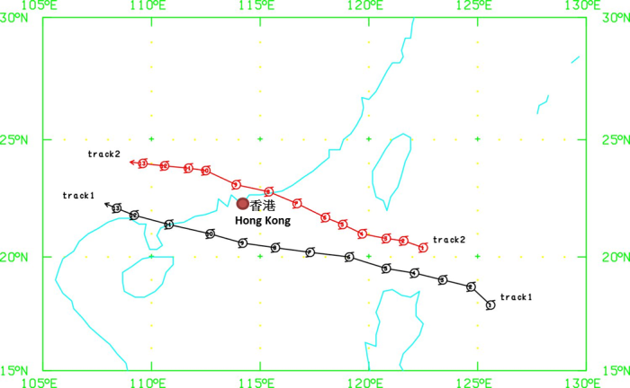
Figure 6(a) Track of a tropical cyclone passing to the south or southwest of Hong Kong (Track 1) and one to the east or north of Hong Kong (Track 2)
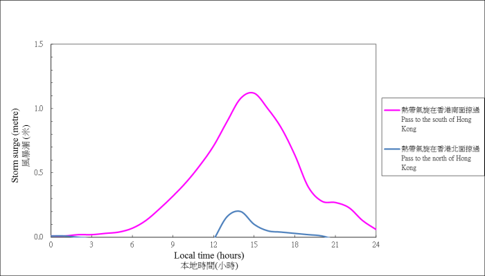
Figure 6(b) Model-simulated storm surges at the Victoria Harbour generated by tropical cyclones with the same minimum central pressure of 980 hPa and radius of maximum winds of 50 km, but moving along different tracks as shown in Figure 6(a): red for Track 1 and blue for Track 2.
Shape of coastline
Storm surge is higher at bag-shaped bays than in channels. The sea water pushed towards the coast by on-shore winds will be trapped more easily by bag-shaped bays and the resultant sea level will be higher. This can be illustrated by storm surges at Tai Po Kau with a bag-shaped coastline in comparison with storm surges at the Victoria Harbour (Figure 7).
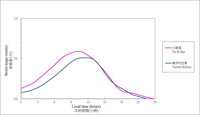
Figure 7 Model-simulated storm surges at Tai Po Kau (red) and Victoria Harbour (blue) generated by a tropical cyclone with a minimum central pressure of 980 hPa and a radius of maximum winds of 50 km passing to the south of Hong Kong along a track as shown in Figure 4(a).
Terminology
Astronomical tide
Astronomical tide is the rise and fall of sea levels caused by the combined effects of gravitational forces exerted by the Moon, the Sun and the rotation of the Earth.
Storm surge
Storm surge is a rise of sea level due to the combined effects of low atmospheric pressure and high winds associated with tropical cyclones.
Storm tide
Storm tide is the sea level during a tropical cyclone due to the combination of storm surge and astronomical tide.
Hong Kong Principal Datum (HKPD)
In Hong Kong, all heights and levels on land refer to the Principal Datum, formerly known as the Ordnance Datum. HKPD was previously determined by Dr. William Doberck, the first Director of the Hong Kong Observatory, as 1.125 m below the Mean Sea Level for the years 1887-1888. This figure was superseded by the updated Mean Sea Level derived using 19 years (1965-1983) of observation records from the automatic tide gauge at North Point, Victoria Harbour operated by the Hong Kong Observatory (Mean Sea Level (1965-1983)). HKPD was then determined as 1.230 m below Mean Sea Level (1965-1983).
Chart Datum (CD)
The Chart Datum, formerly known as the Admiralty Datum, is approximately the level of Lowest Astronomical Tide and is adopted as the zero point for Tide Tables since 1917. At present, CD is 1.376 m below Mean Sea Level (1965-1983), or 0.146 m below HKPD.
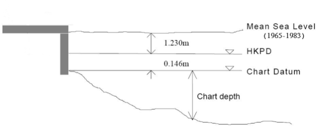
Figure 8 Illustration of Chart Datum