Latest status of El Niño and La Niña
El Niño and La Niña
Latest status (September 2026)
Sea surface temperatures of the central and eastern equatorial Pacific stayed above normal for five consecutive months from April to August 2026, and the sum of the sea surface temperature anomalies exceeded 4.0°C. An El Niño event has been established. Based on the latest oceanic observations as well as forecasts by a number of climate models around the world, the warming trend in the central and eastern equatorial Pacific is expected to continue. The El Niño event is expected to peak around November to December this year and to persist at least until spring next year. It is forecast to strengthen into a very strong event, with a chance of becoming the strongest El Niño event on record since 1950.
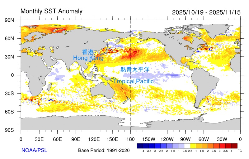
Figure 1 Sea surface temperature anomalies of 30 August 2026 – 26 September 2026 in degree Celsius.
Note:
The next update will be available in the latter half of October 2026.
Related links:
What are El Niño, La Niña, ENSO?
The impact of El Niño and La Niña on the climate of Hong Kong
Seasonal and annual rainfall charts
Blogs, notes and videos relating to El Niño and La Niña
References on El Niño and La Niña
Seasonal forecast | Annual outlook | Climate change
For further information on this webpage, please contact Ms. M Y Chan (tel:2926 3102, email:mychan@hko.gov.hk)