Overview of Tropical Cyclone in September 2025
|
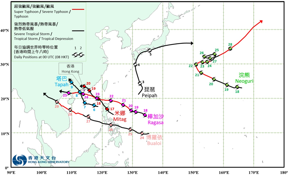
Six tropical cyclones occurred over the western North Pacific and the South China Sea in September 2025. Among them, Tapah (2516), Mitag (2517) and Ragasa (2518) necessitated the issuance of the tropical cyclone warning signal by the Observatory. Peipah (2515) formed as a tropical depression over the western North Pacific about 720 km southeast of Okinawa on the night of 2 September, and moved generally northwards towards Kyushu, Japan. It intensified into a tropical storm on the afternoon of 4 September, skirted past the coastal areas of southeastern Kyushu, Japan, and gradually turned to track east-northeastwards. Peipah moved across the coastal areas of southern Shikoku and Honshu, Japan on 5 September, and attained its peak intensity with an estimated maximum sustained wind of 85 km/h near its centre over the seas east of Honshu, Japan that night. It finally evolved into an extratropical cyclone over the western North Pacific east of Japan on the morning of 6 September. According to press reports, the southwest monsoon and Peipah brought heavy rain to the Philippines, causing over 350 000 people affected and more than 120 houses damaged. Peipah also brought torrential rain and squalls to Japan. A record-breaking 24-hour rainfall reaching 465.5 millimetres was recorded in Tsuno in Miyazaki Prefecture, Kyushu. There were reports of tornadoes in the coastal areas of Shikoku and southeastern part of Honshu, with a maximum gust of around 270 km/h recorded during the passage of the tornado in Shizuoka Prefecture, making it one of the strongest tornadoes recorded in Japan since 1961. Peipah caused two deaths and 90 injuries in Japan. More than 1 200 houses were damaged, and electricity supply to over 4 200 households was disrupted. Tapah (2516) formed as a tropical depression over the central part of the South China Sea about 390 km south-southeast of Dongsha on the night of 5 September, and moved west-northwestwards across the central and northern parts of the South China Sea. It turned to track north-northwestwards towards the coast of western Guangdong on the morning of 7 September, and intensified into a severe tropical storm that night. Tapah attained its peak intensity in the small hours of 8 September, with an estimated maximum sustained wind of 110 km/h near its centre. It made landfall near Taishan of Guangdong that morning, then gradually turned northwestwards and moved inland, where it weakened rapidly. Tapah finally degenerated into an area of low pressure in Guangxi on the morning of 9 September. According to press reports, the southwest monsoon and Tapah brought heavy rain to the Philippines, affecting over 83 000 people. During the passage of Tapah over southern China, accumulated rainfall in parts of Jiangmen and Zhuhai of Guangdong reached 434 millimetres, and hourly rainfall in Haikou of Hainan reached 124 millimetres. In Hainan, Guangdong, Guangxi, and Yunnan, more than 290 000 people were affected and over 210 000 were evacuated during the passage of Tapah. In Macau, there were four injuries and 25 incident reports. At least 81 flights were cancelled at the Macau International Airport. For detailed information of Tapah including its impact to Hong Kong, please refer to the Tropical Cyclone Report of Tapah. Mitag (2517) formed as a tropical depression over the seas east of Luzon about 300 km east-northeast of Manila on the afternoon of 16 September. It moved generally northwestwards across Luzon and the northeastern part of the South China Sea in the following two days, approaching the coast of eastern Guangdong. Mitag intensified into a severe tropical storm on the morning of 19 September, attaining its peak intensity with an estimated maximum sustained wind of 90 km/h near its centre. It made landfall near Shanwei of Guangdong that afternoon, then turned west-northwestwards and moved inland, where it weakened rapidly. Mitag finally degenerated into an area of low pressure over Guangdong on the morning of 20 September. According to press reports, Mitag brought heavy rain and caused flooding in the Philippines. Mitag and its remnant brought torrential rain and squalls to Taiwan, Fujian, Guangdong and Guangxi, with more than 130 000 people affected and over 100 000 people evacuated. For detailed information of Mitag including its impact to Hong Kong, please refer to the Tropical Cyclone Report of Mitag. Neoguri (2519) formed as a tropical depression over the western North Pacific about 420 km north of Wake Island on the night of 17 September, and moved westwards or west-northwestwards in the following three days. It rapidly intensified into a super typhoon in the small hours of 21 September, attaining its peak intensity with an estimated maximum sustained wind of 195 km/h near its centre. Neoguri turned to track generally eastwards in the following two days and weakened into a severe tropical storm on the afternoon of 24 September. It then made an anti-clockwise loop in the following two days, and began to pick up speed and turned northeastwards on 27 September. Neoguri re-intensified into a severe typhoon the next day, making it one of the few tropical cyclones that remained at or above severe typhoon intensity at or north of 35°N. Neoguri finally evolved into an extratropical cyclone over the western North Pacific on the morning of 29 September. Ragasa (2518) formed as a tropical depression over the western North Pacific about 1 450 km east of Manila in the small hours of 18 September and moved generally west-northwestwards towards the Luzon Strait in the following three days. As the tropical cyclone heat potential was relatively high over the western North Pacific to the east of the Philippines, together with favourable upper-level divergence and weak vertical wind shear, Ragasa rapidly intensified into a super typhoon in the small hours on 21 September and attained its peak intensity that night, with an estimated maximum sustained wind of 230 km/h near its centre. Ragasa adopted a westerly track across the Luzon Strait the next day. As its centre did not pass over major landmasses such as Luzon or Taiwan, its structure remained intact with extensive circulation and a clear, well‑defined eye as it entered the South China Sea. The maximum sustained wind near its centre remained at 230 km/h, making it the strongest tropical cyclone in the western North Pacific and the South China Sea region in 2025. It is also the second strongest tropical cyclone in the South China Sea since the Observatory’s records began in 1950, on par with Super Typhoons Saola in 2023 and Yagi in 2024. Ragasa turned to track west-northwestwards across the northern part of the South China Sea on 23 September and edged closer to the coast of Guangdong the next morning. Due to favourable atmospheric and oceanic conditions in the South China Sea, Ragasa maintained its super typhoon intensity throughout. It made landfall near Yangjiang of Guangdong on the afternoon of 24 September and then weakened rapidly. It moved across the coast of Guangxi the next day and finally degenerated into an area of low pressure over the northern part of Vietnam that night. According to press reports, Ragasa brought torrential rain and squalls to the northern part of the Philippines, resulting in many casualties and severe damage. Under the influence of the outer rainbands of Ragasa, torrential rain caused the overflow of the Matai'an barrier lake in Taiwan, flooding three downstream townships and resulting in 19 deaths, five missing persons, and 157 injuries. Water and electricity supplies to more than 4 300 and 17 000 households were disrupted respectively in Taiwan. Economic loss exceeded USD 19 million. More than 3.87 million people in Zhejiang, Fujian, Guangdong, Guangxi, Hainan and Yunnan were also affected, with over 5 000 houses damaged. Over 53 000 trees were damaged in Yangjiang of Guangdong. Approximately 50 000 hectares of crops were damaged and economic loss exceeded RMB 15.8 billion. Maximum gust of 234 km/h was recorded on Shangchuan Dao in Taishan, the highest on record by a national meteorological station in Guangdong. Besides, eight people were injured when Ragasa affected Macau. Electricity supply to about 16 000 households was disrupted. There were also 259 incident reports. At least 206 flights were cancelled at the Macau International Airport. For detailed information of Ragasa including its impact to Hong Kong, please refer to the Tropical Cyclone Report of Ragasa. Bualoi (2520) formed as a tropical depression on the afternoon of 23 September over the western North Pacific about 300 km west of Yap, moved generally west-northwestwards towards the central part of the Philippines and intensified gradually in the following two days. It moved across the central part of the Philippines on 26 September, and entered the southern part of the South China Sea that night. Bualoi intensified into a typhoon while moving across the central part of the South China Sea the next day and attained its peak intensity in the small hours of 28 September, with an estimated maximum sustained wind of 130 km/h near its centre. Bualoi made landfall over the central part of Vietnam in the small hours of the next day, then moved inland and weakened rapidly. It finally degenerated into an area of low pressure in Lao PDR in the small hours of 30 September. According to press reports, Mitag, Ragasa and Bualoi hit the Philippines successively, causing at least 53 deaths, three missing persons and 61 injuries. More than 5.3 million people were affected, more than 180 000 houses were damaged, and economic loss exceeded PHP 5.7 billion. Under the influence of the outer circulation of Bualoi, there were torrential rain and severe convective weather in Hainan, Guangdong, Guangxi and Yunnan on 28 – 29 September. Over 490 000 people were affected and 70 000 people were evacuated. There were at least 26 reports of tornadoes or waterspouts in Haikou of Hainan, Zhanjiang of Guangdong and Beihai of Guangxi. Bualoi also brought torrential rain and squalls to Vietnam, causing flooding and landslides in many places and resulting in 57 deaths, 10 missing, and 172 injuries. Approximately 180 000 houses were damaged and economic loss amounted to about VND 24 trillion. Accumulated rainfall exceeding 600 millimetres was recorded in Thanh Hoa and Nghe An, while tornadoes were reported in Ninh Binh, Hung Yen and Hai Phong. The torrential rain induced by Bualoi and its remnant also caused flooding in Lao PDR, Cambodia, Thailand and Myanmar. In Lao PDR, there were at least four deaths, four missing and 36 000 people affected. In Thailand, there were 12 deaths, one missing and over 290 000 affected. |
Provisional Tropical Cyclone Tracks in September 2025