Overview of Tropical Cyclone in June 2025
|
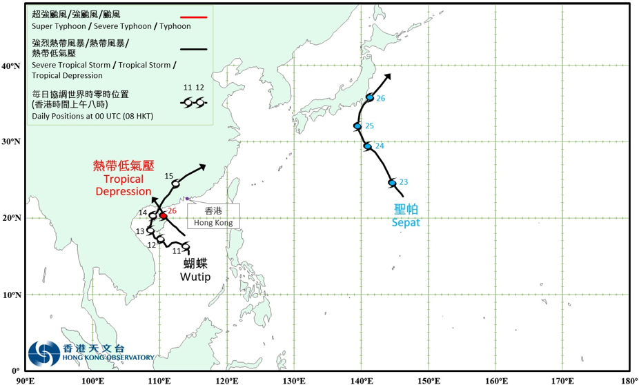
Three tropical cyclones occurred over the western North Pacific and the South China Sea in June 2025. Among them, Wutip (2501) and a tropical depression necessitated the issuance of the tropical cyclone warning signal by the Observatory. Wutip (2501) formed as a tropical depression over the central part of the South China Sea about 280 km southeast of Xisha on the night of 10 June. It moved generally west-northwestwards towards the seas south of Hainan Island and intensified gradually the next day. Wutip intensified into a severe tropical storm on the night of 12 June. It attained its peak intensity in Beibu Wan on the morning of 13 June, with an estimated maximum sustained wind of 110 km/h near its centre. Wutip gradually turned to track north-northeastwards that day and made landfall over Dongfang of Hainan Island that night. After skirting across the western coast of Hainan Island, Wutip entered Beibu Wan again the next day and made landfall again over Zhanjiang of Guangdong around noon. It then moved into inland areas of southern China and weakened gradually. Wutip finally degenerated into an area of low pressure on the evening of 15 June. According to press reports, Wutip brought torrential rain to the central part of Vietnam, triggering flooding that resulted in nine deaths, two missing, and more than 3 500 houses affected. Maximum 6-hour rainfall of 319.4 millimetres and 72-hour rainfall of 1 203 millimetres were recorded over the region. Wutip also brought very heavy rain and squalls to Hainan, Guangxi and Guangdong, causing flooding and landslides that led to seven deaths and an estimated direct economic loss of RMB 1.81 billion. During Wutip’s passage across the vicinity of the Guangdong-Guangxi boundary, a 24-hour rainfall of 401.5 millimetres was recorded at Yulin in Guangxi. For detailed information of Wutip including its impact to Hong Kong, please refer to the Tropical Cyclone Report of Wutip. Sepat (2502) formed as a tropical depression over the western North Pacific about 540 km east-southeast of Iwo Jima on the afternoon of 22 June, and moved generally northwestwards. While moving across the seas northeast of Iwo Jima on the afternoon of 23 June, Sepat intensified into a tropical storm and attained its peak intensity with an estimated maximum sustained wind of 65 km/h near its centre. It gradually turned to move northeastwards over the seas south of Honshu of Japan in the following two days. Sepat finally evolved into an extratropical cyclone over the seas east of Honshu of Japan on the night of 26 June. A tropical depression formed over the central part of the South China Sea about 170 km northeast of Xisha on the morning of 25 June and moved northwestwards towards the eastern part of Hainan Island. It attained its peak intensity with an estimated maximum sustained wind of 55 km/h near its centre on the evening of 25 June. After skirting across Wenchang of Hainan Island in the small hours on 26 June, it made landfall again over Zhanjiang of Guangdong that morning. The tropical depression then moved inland and finally degenerated into an area of low pressure over Guangxi in the small hours of the next day. According to press reports, the tropical depression brought very heavy rain and squalls to Hainan Island and Zhanjiang of Guangdong. A maximum accumulated rainfall of 218.2 millimetres was recorded in Wenchang of Hainan Island. For detailed information of the tropical depression including its impact to Hong Kong, please refer to the Tropical Cyclone Report of the tropical depression. |
Provisional Tropical Cyclone Tracks in June 2025