Overview of Tropical Cyclone in November 2024
|
Five tropical cyclones occurred over the western North Pacific and the South China Sea in November 2024. Among them, Yinxing, Toraji, Usagi and Man-yi co-existed in the region, the first time in November since 1961 that four tropical cyclones occurred concurrently in the region. In addition, Yinxing, Usagi and Man-yi reached super typhoon intensity, on par with November 1990 for the most super typhoons occurred in November since 1961. Besides, Yinxing, Toraji and Man-yi affected Hong Kong one after another, necessitating the issuance of tropical cyclone warning signals for these three episodes, the first time in November since 1946. Kong-rey formed as a tropical depression over the western North Pacific about 870 km east-northeast of Yap on the morning of 25 October. In the following three days, it tracked generally westwards or west-northwestwards across the western North Pacific to the east of Luzon, and gradually intensified into a severe tropical storm. Kong-rey turned to move northwestwards towards the southeastern part of Taiwan on 29 October, and rapidly intensified into a super typhoon, attaining its peak intensity with an estimated maximum sustained wind of 205 km/h near its centre the next morning. Kong-rey weakened rapidly while moving across Taiwan on the afternoon of 31 October and entered the Taiwan Strait that night. It turned to move north-northeastwards towards the coast of Fujian to Zhejiang in the small hours of 1 November, weakened into a tropical storm that morning, and finally evolved into an extratropical cyclone over the coastal waters of Zhejiang that night. According to press reports, Kong-rey and Trami in late October caused a total of 159 deaths, 22 missing and 132 injuries in the Philippines. More than 9.6 million people were affected, more than 200 000 houses and over 130 000 hectares of crops were damaged. Economic loss exceeded PHP 18.4 billion. Kong-rey brought torrential rain and squalls to Taiwan, with 1-hour rainfall reaching 119.5 millimetres over parts of Hualien. Kong-rey caused three deaths and 692 injuries in Taiwan. Water and electricity supplies to more than 60 000 and 970 000 households were disrupted respectively. More than 34 000 hectares of crops were damaged. Economic loss exceeded USD 73 million. Air traffic was also affected, with over 500 flights cancelled. Besides, Kong-rey also brought torrential rain to the coastal areas of eastern China. In Zhejiang, Fujian, Jiangsu and Shanghai, more than 420 000 people were affected and more than 50 000 people were evacuated. Over 54 000 hectares of crops were damaged. Economic loss exceeded RMB 650 million. Kong-rey and the extratropical cyclone it evolved into also brought torrential rain to the Republic of Korea and Japan. 24-hour rainfall of 268.5 and 378 millimetres were recorded over parts of Jeju, the Republic of Korea and Kyushu, Japan respectively. In Japan, there were at least one missing and three injuries. Yinxing formed as a tropical depression over the western North Pacific about 110 km southeast of Yap on the morning of 3 November. It moved west-northwestwards or northwestwards towards Luzon and intensified progressively into a typhoon in the following two days. It turned gradually to move westwards on 6 November and intensified into a super typhoon that night. Yinxing attained its peak intensity the next afternoon with an estimated maximum sustained wind of 220 km/h near its centre. It then moved across the northern tip of Luzon and weakened slightly into a severe typhoon in the small hours of 8 November. Yinxing tracked generally westwards across the northern part of the South China Sea and intensified again into a super typhoon on 9 November. It turned to move southwestwards over the seas southeast of Hainan Island and weakened rapidly in the following two days. Yinxing finally weakened into an area of low pressure over the coastal waters of central Vietnam on 12 November. According to press reports, Yinxing caused one death, one missing and one injury during its passage over the northern part of the Philippines. More than 380 000 people were affected, over 28 000 houses were damaged and economic loss exceeded PHP 192 million. For detailed information of Yinxing including its impact to Hong Kong, please refer to the Tropical Cyclone Report of Yinxing. Toraji formed as a tropical depression over the western North Pacific about 1 270 km east of Manila on the morning of 9 November. It then moved west to west-northwestwards towards Luzon and intensified into a tropical storm that night. Toraji intensified progressively into a typhoon the next day and attained its peak intensity over the coastal waters east of Luzon with an estimated maximum sustained wind of 130 km/h near its centre on the morning of 11 November. Toraji moved across Luzon during the day that day and gradually turned to move northwestwards and entered the central part of the South China Sea that evening. Toraji moved towards the coast of Guangdong and weakened gradually into tropical storm in the following two days. It turned to move westwards slowly across the seas south of Hong Kong on the morning of 14 November. Toraji finally degenerated into an area of low pressure over the seas south of Shangchuan Dao on the morning of 15 November. According to press reports, Toraji brought heavy rain and squalls to the Philippines, leading to flooding in many places and many casualties. For detailed information of Toraji including its impact to Hong Kong, please refer to the Tropical Cyclone Report of Toraji. Man-yi formed as a tropical depression over the western North Pacific about 1 840 km east of Guam in the small hours of 9 November, moved west-northwestwards, and intensified into a tropical storm that day. It turned to adopt a west-southwesterly track across the seas near Guam in the following four days. It turned gradually from moving westwards to northwestwards towards Luzon on 14 – 16 November. Man-yi intensified into a super typhoon in the small hours of 16 November and attained its peak intensity with an estimated maximum sustained wind of 220 km/h near its centre that morning. It moved across Luzon on 17 November, entered the central part of the South China Sea, and weakened rapidly. It then moved generally west-northwestwards across the northern part of the South China Sea the next day. Man-yi gradually turned to track west-southwestwards on the afternoon of 19 November and finally weakened into an area of low pressure over the seas southeast of Hainan Island in the small hours of 20 November. According to press reports, Man-yi brought heavy rain and squalls to the Philippines, resulting in flooding and severe damage in many places. It caused many fallen trees, damaged houses and many casualties. For detailed information of Man-yi including its impact to Hong Kong, please refer to the Tropical Cyclone Report of Man-yi. Usagi formed as a tropical depression over the western North Pacific about 280 km north-northeast of Yap on the morning of 11 November, and moved west-northwestwards across the western North Pacific to the east of the Philippines. Usagi intensified rapidly into a typhoon in the small hours of 13 November. It further intensified into a super typhoon, attaining its peak intensity with an estimated maximum sustained wind of 185 km/h near its centre in the small hours of 14 November. Usagi turned to move northwestwards that morning, and weakened into a severe typhoon upon crossing the northeastern part of Luzon that afternoon. As Usagi moved across the Luzon Strait on 15 November, it gradually turned to move north-northeastwards towards the southwestern part of Taiwan and weakened rapidly into a tropical storm. Usagi lingered off the southwestern coast of Taiwan on the morning of 16 November and finally degenerated into an area of low pressure in the region that afternoon. According to press reports, Toraji, Usagi and Man-yi hit the Philippines successively, causing a total of 14 deaths, two missing, 15 injuries and more than 4.3 million people affected. More than 78 000 houses and over 41 000 hectares of crops were damaged. Economic loss exceeded PHP 3.7 billion. During the passage of Usagi over Taiwan, a 24-hour rainfall of 472.5 millimetres was recorded in Dahan Shan of Pingtung. Usagi caused at least one injury in Taiwan. Electricity supply to more than 1 500 households was disrupted. Around 18 flights were cancelled. |
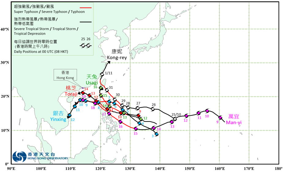
Provisional Tropical Cyclone Tracks in November 2024
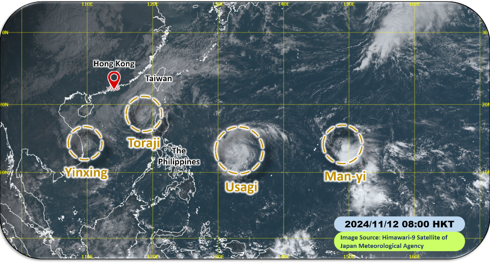
Satellite imagery at around 8 a.m. on 12 November 2024, showing that four tropical cyclones occurred concurrently over the western North Pacific and the South China Sea, the first time in November since 1961.
[The satellite imagery was originally captured by Himawari-9 Satellite (H-9) of Japan Meteorological Agency.]