Challenges in Rainfall Nowcasting
Challenges in Rainfall Nowcasting
LEE Sung-ho, LEUNG Ka-fai Bosco
October 2024
During the wet season, heavy rain brings inconvenience to the members of the public when commuting and venturing outdoors. To predict the development of rainfall in the next couple of hours and to assess the necessity of issuing corresponding rainstorm warning signals, weather forecasters closely monitor and analyze various weather observational data, as well as making reference to the forecasts from the “SWIRLS” (Short-range Warning of Intense Rainstorms in Localized Systems) nowcasting system.
SWIRLS primarily relies on data from weather radars and surface automatic rain gauges. It utilizes two successive and latest radar scans of rain echo images to analyse the moving direction and speed of rain areas. Subsequently, the location and rainfall intensity for the next couple of hours are computed based on the movement of the echoes. However, rainstorms and its associated severe convective weather systems evolve rapidly with significant uncertainties in the affected areas and rainfall intensities. They pose considerable challenges for nowcasting and are illustrated in the following cases.
1. Rapid Development of Rainstorms
Weather radar performs a complete scan in 6 minutes. However, the convective weather system and rainfall developments have considerable variabilities that they can intensify and weaken during the period of time. As SWIRLS makes use of the latest two successive radar scans for prediction, the resulting rainfall nowcast may deviate from the actual subsequent developments if the radar may not capture the rapid changes of the rain area between the scans.
Consider the scenario on 21 Apr 2024 depicted in Figure 1. An intense rain band located over the Pearl River Estuary (PRE) was gradually approaching Hong Kong from the west during the morning. Given that the region of heaviest rainfall was mainly located over PRE, the rainfall nowcast based on 10:06 am indicated an eastward advancement of the rain band and gradually affecting the western parts of the territory (Figure 2). However, the actual situation revealed that several isolated areas of intense rainfall started to develop ahead of the main rain band around 10:36 am (Figure 1 (b) - (c), circled in red). This led to some regions experiencing heavy rain earlier than anticipated and differed from the previous results of the rainfall nowcast.
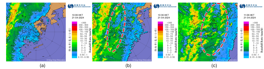
Figure 1 Radar echo images at (a) 10:06 am, (b) 10:36 am; and (c) 11:06 am on 21 April 2024.
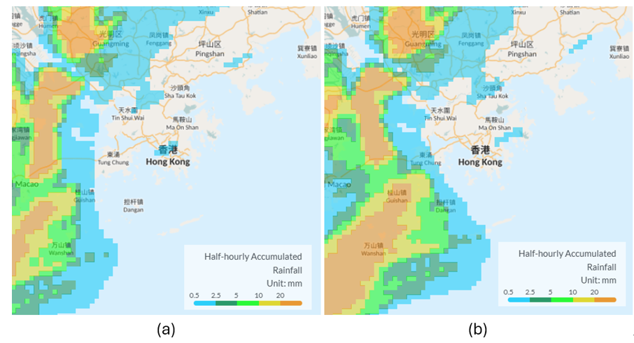
Figure 2 SWIRLS nowcast half-hourly accumulated rainfall based on the radar scan at 10:06 am on 21 April 2024, valid at (a) 10:36 am; and (b) 11:06 am.
2. Terrain Effect
Hong Kong has a complex orography. During the spring and summer times with favourable meteorological conditions, moist unstable air masses are forced to ascend when they encounter mountainous terrain, leading to formation of clouds and precipitation. According to a previous study [1], when Hong Kong is affected by southerly winds, the formation of orographic precipitation and intensification of rainfall is more favourable around major hills including Tai Mo Shan, Sunset Peak, Ma On Shan and Mount Parker.
In an example shown in Figure 3 and Figure 4, Hong Kong was under the influence of southwesterly winds on 27 July 2024. In the afternoon, radar image indicated the initiation of rainfall over northeastern Lantau Island and Tai Mo Shan, followed by a persisting intensification over Shatin, Tai Po and northeastern part of New Territories (Figure 3 (b) and (c), circled in red). During the early development of orographic rainfall, only relatively weak and scattered echoes are typically detected by radar (Figure 3 (a)). Based on the radar detection and relatively weak echo intensity, SWIRLS predicted rainfall over the New Territories for the following couple of hours was thus relatively less and confined (Figure 4). This illustrates difficulties in predicting rainfall development in the downstream areas due to terrain effect.
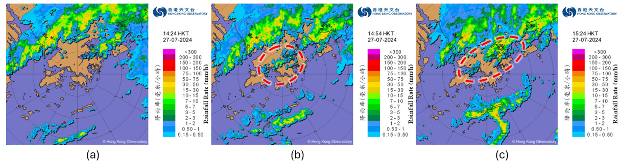
Figure 3 Radar echo images at (a) 2:24 pm, (b) 2:54pm and (c) 3:24 pm on 27 July 2024.
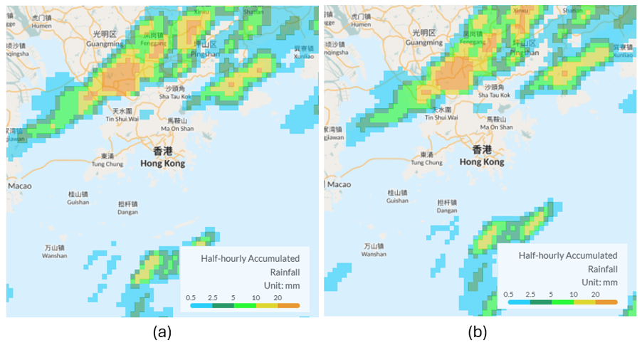
Figure 4 “SWIRLS” nowcast half-hourly accumulated rainfall based on the radar scan at 2:24 pm on 27 July 2024, valid at (a) 2:54 pm; and (b) 3:24 pm.
3. 'Blind areas' of Weather Radar
To minimize terrain obstruction, the two weather radars of the Observatory were installed atop Tai Mo Shan (about 970m above sea level) and Tate’s Cairn (about 580m above sea level). When the radars scan at their lowest zenith angle, echoes from about 1 km above the ground level can be detected. Consequently, precipitation at lower altitudes remains undetected by weather radars. In particular, rainfall associated with stratiform clouds during the cool season are often ‘invisible’ in radar images. On 4 March 2024, Hong Kong was affected by a humid southerly airstream. The weather was mainly cloudy and misty with a few rain patches. Between 2 to 3 am, 0.5 to 2 mm of rainfall was observed over the eastern parts of the territory, while 2 to 5 mm was observed over some parts of Sai Kung (Figure 5(a)). However, there were only weak echoes in the radar image (circled in red Figure 5(b)). Under this circumstance, it is difficult for SWIRLS to forecast the occurrence of rainfall, but rain was actually recorded.
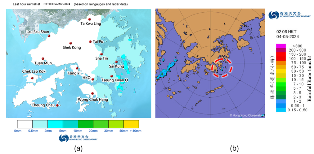
Figure 5 (a) Last hour rainfall map at 3:00 am on 27 July 2024; (b) radar echo image at 2:06 am.
At present, there is still technological limitations in predicting rainfall evolution. Precipitation nowcast often deviates from the actual situations. In recent years, the Observatory has been dedicated to enhancing the location-specific rainfall nowcast. Leveraging advancements in artificial intelligence, deep learning models are being trained using weather Big Data and high-performance computers to enhance rainfall forecasts for the next few hours. Under climate change, the occurrence of extreme precipitation is expected to be more frequent. Severe weather associated with intense convective activities will pose greater challenge to Hong Kong in the future. The role of rainfall nowcasting service in alerting rainstorm hazards is set to become more critical. The Observatory will continue to spare no effort in developing cutting-edge nowcasting technologies to enhance weather forecasting and warning services, enabling early preparedness on extreme weather by the general public.
Note :
[1] Case Studies on Orographic Rainfall in Hong Kong (Available in Chinese only)
[1] Case Studies on Orographic Rainfall in Hong Kong (Available in Chinese only)