|
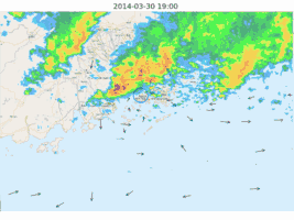
The rain season in 2014 unveiled in a rather dramatic way, not only did it coincided with the Observatory's Open Day on 29 and 30 March, the extensive and intensive convection triggered both Red and Black rainstorm warnings on 30 March which marked the earliest Red and Black rainstorm signals in a year since the warning system started operation in 1992, and there were hail reports in many parts of the territory (Note 1).
Impacts to the airport and air traffic were equally high. The airport lightning warning had been Red halting ground operation, high gusts and tailwind in squalls caused diversion and much delay, and reportedly there were departing aircraft encountered hail stones. Amid all these lights and bells and whistles, in their literal meaning, maybe it is a good time to recap some of the information provided by Airport Meteorological Office (AMO) at the Hong Kong International Airport (HKIA) for dealing with bad weather situations.
AMO issues tailored category forecasts of significant convection for up to 12 hours for the key holding areas and air spaces. Closer to the aerodrome, weather elements at the runways like tailwind, crosswind, ceiling and visibility, categorized for local performance thresholds, were given for 9 hours ahead (Note 2). The Civil Aviation Department of Hong Kong then issues capacity notifications to inform users on air traffic condition and arrival delay based on weather and operational considerations (Note 3). Apart from weather information to support strategic planning, the Hong Kong Observatory (HKO) has also strengthened the weather information to support tactical decision. When it comes to tactical decision, latest information on convection and their evolution are of crucial importance. For HKIA, the latest ATIS not only contain the METAR/SPECI and TREND type forecast, but also information on thunderstorm activity within 50nm of the airport if the thunderstorm is going to affect the arrival or departure corridors (Note 4). All the information above is available on HKO's Aviation Meteorological Information Dissemination System (AMIDS) which is a dedicated website for the aviation community, and there is also a mobile APP for it (Note 5).
Eyeing on the future, those blasts and whirls and flashes are sure to visit again. However, there could be big differences in the way the aviation industry handles weather in the future. The 14th ICAO Meteorology Divisional Meeting, in part conjointly with the Fifteenth Session of the World Meteorological Organization (WMO) Commission for Aeronautical Meteorology (CAeM-XV), will discuss the "One Sky" concept, trajectory-based operation, regional centres of hazardous weather and system-wide information management. All these will profoundly affect how, what, whom, when and where the pilots obtain the weather information.
The conjoint meeting is going to be held from 7 to 18 July and we will keep you updated on the outcomes of the meeting then, so stay tuned.
Note 1: HKO has issued a press release on it: (http://www.hko.gov.hk/en/press/pre20140331e.htm)
Note 2: For product detail, see here: (http://www.weather.gov.hk/en/aviat/outreach/AMIDS/26th/6hrTSForecast.htm)
Note 3: There is another article detailing the capacity notification, also in this issue.
Note 4: Please refer to a previous article detailing the new service: (http://www.weather.gov.hk/en/aviat/outreach/AMIDS/28th/terminalts.htm)
Note 5: For the MyAeroMET mobile app, refer to this article for detail: (http://www.hko.gov.hk/en/hkonews/sidelight_a1_131219.htm)
|