New 6-h significant convection forecast for selected key ATC areas
|
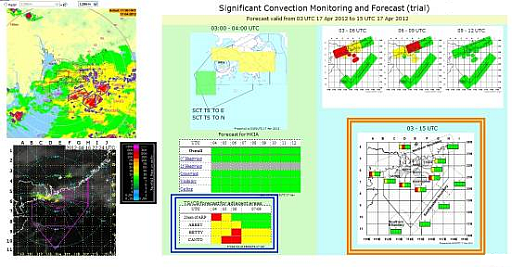
Commencing 10 April 2012, the AMIDS webpage for "Significant Convection Monitoring and Forecast" has been enhanced with the addition of trial hourly significant convection forecast for selected key air traffic control (ATC) areas for the next 6 hours. These areas include an area within 20nm of the Aerodrome Reference Point (ARP), ABBEY, BETTY and CANTO holding areas again with a radius of 20 nm. Different colours (green/yellow/red) indicate various levels of chance (low/medium/high) of significant convection bringing significant air traffic disruption. This is to supplement the current 12-hour significant convection forecast time series for key ATC areas with higher temporal resolution for the first few hours. |
|
Figure 1 A sample display of the integrated webpage for "Significant Convection Monitoring and Forecast". The recently launched 6-hour significant convection forecast for selected key ATC areas (marked by the blue box) supplements the 12-hour significant convection forecast (marked by the orange box) in which each colour bar contains 12-hour forecast for a specified region and each colour block inside the bar spans 3 hours.
|