The Weather of May 2002
|
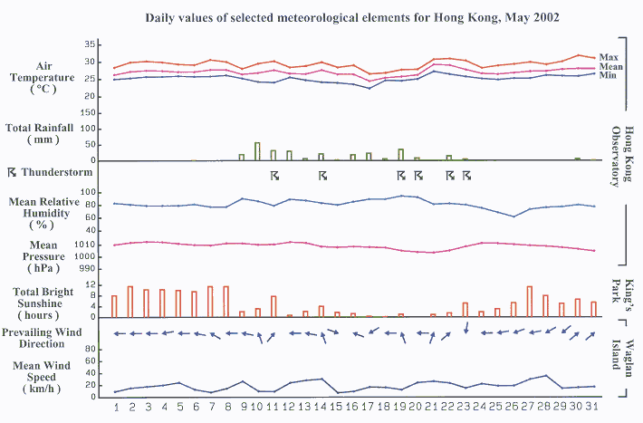
May 2002 was the sixth warmest May on record. The mean temperature of 27.0 degrees was 1.1 degrees above normal. It was slightly drier with a monthly rainfall amount of 275.6 millimetres, 13 percent below normal. The accumulated rainfall since the beginning of the year was 556.3 millimetres, about 10 percent below normal for the same period. Apart from a few brief showers, the weather of the first eight days of the month was hot and sunny. A trough of low pressure over Guangdong moved towards the coast on 9 May, marking the beginning of several days of unsettled weather with occasional heavy showers. Rain eased off on 13 May when a ridge of high pressure built up along the coast of southeast China. With the summer monsoon setting in, weather deteriorated again on 14 May. Some members of the public reported seeing a funnel cloud near Tsing Ma Bridge that morning. For the next several days, a monsoon trough lingered along the coast of south China, bringing cloudy weather with occasional rain and thunderstorms to Hong Kong. In the evening of 20 May, there was a report of very windy conditions resembling a tornado on Chek Lap Kok Island amidst active thunderstorms. The event was captured by the Observatory's Terminal Doppler Weather Radar at Tai Lam Chung. Opposing winds estimated to exceed 90 kilometres per hour affected an area about one kilometre across. The monsoon trough continued to bring unsettled weather to Hong Kong on 21 and 22 May. When the southwest monsoon gave way to a continental airstream on 23 May, the weather improved gradually and there were long sunny periods in the ensuing days. However, a trough of low pressure developed over Guangdong on 30 May and brought another episode of widespread rain and isolated thunderstorms to Hong Kong that evening. Besides a few showers in the morning, the weather became mainly fine again on the last day of the month. Hagibis was the only tropical cyclone which occurred in the western North Pacific in the month. Details of issuance and cancellation of various warnings/signals in the month are summarized in Tables 1.1 to 1.3. Monthly meteorological figures and departures from normal for May are tabulated in Table 2. |
Warnings and Signals issued in May 2002
| Beginning Time | Ending Time | ||
|---|---|---|---|
| Day/Month | HKT | Day/Month | HKT |
| 13 / 5 | 1030 | 13 / 5 | 1300 |
| 20 / 5 | 1915 | 20 / 5 | 2330 |
| Colour | Beginning Time | Ending Time | ||
|---|---|---|---|---|
| Day/Month | HKT | Day/Month | HKT | |
| Amber | 10 / 5 | 0645 | 10 / 5 | 0745 |
| Amber | 11 / 5 | 0420 | 11 / 5 | 0600 |
| Amber | 20 / 5 | 2040 | 21 / 5 | 0010 |
| Amber | 22 / 5 | 2150 | 23 / 5 | 0120 |
| Beginning Time | Ending Time | ||
|---|---|---|---|
| Day/Month | HKT | Day/Month | HKT |
| 10 / 5 | 0345 | 10 / 5 | 0845 |
| 10 / 5 | 1445 | 10 / 5 | 1655 |
| 11 / 5 | 0130 | 11 / 5 | 0630 |
| 12 / 5 | 0750 | 12 / 5 | 0950 |
| 14 / 5 | 1645 | 14 / 5 | 2300 |
| 16 / 5 | 1000 | 16 / 5 | 1200 |
| 16 / 5 | 1905 | 17 / 5 | 0800 |
| 19 / 5 | 0900 | 19 / 5 | 1100 |
| 19 / 5 | 1625 | 19 / 5 | 2100 |
| 20 / 5 | 1930 | 21 / 5 | 0600 |
| 22 / 5 | 1415 | 23 / 5 | 0615 |
| 30 / 5 | 1445 | 30 / 5 | 2000 |
| 31 / 5 | 0010 | 31 / 5 | 0610 |
| Meteorological Element | Figure of the Month | Departure from Normal |
|---|---|---|
| Mean Daily Maximum Air Temperature | 29.3 degrees C | 0.6 degree above normal |
| Mean Air Temperature | 27.0 degrees C | 1.1 degrees above normal |
| Mean Daily Minimum Air Temperature | 25.2 degrees C | 1.3 degrees above normal |
| Mean Dew Point Temperature | 23.4 degrees C | 0.8 degree above normal |
| Mean Relative Humidity | 81 % | 2 % below normal |
| Mean Cloud Amount | 77 % | 3 % above normal |
| Total Rainfall | 275.6 mm | 41.1 mm below normal |
| Total Bright Sunshine Duration | 160.2 hours | 6.4 hours above normal |
| Mean Daily Global Solar Radiation | 15.59 Megajoule / square metre | 0.53 Megajoule below normal |
| Total Evaporation | 126.0 mm | 11.7 mm below normal |
| Remarks : | All measurements were made at the Hong Kong Observatory except sunshine, solar radiation and evaporation which were recorded at King's Park Meteorological Station. |
