The Year's Weather - 2017
Monday, 8th January 2018
Globally, according to the World Meteorological Organization's preliminary assessment, 2017 is very likely to be one of the three warmest years on record. Over the Arctic, sea-ice extent was well below average throughout 2017 and reached record-low levels for the first four months of the year. Various extreme weather events wreaked havoc in many parts of the world in 2017, including heatwaves in Chile, Argentina, eastern Australia, Turbat of Pakistan, Iran, Oman, Shanghai of China, California of the United States and the Mediterranean region, cold spells in parts of Argentina, southeastern Australia and the Gulf region in the Middle East, drought in Somalia, Kenya, Ethiopia, South Sudan, Uganda, Italy, Spain, Portugal, and the Korean Peninsula. Extreme rainfall triggered severe flooding and landslides in Sierra Leone, southern Colombia, the Indian sub-continent, Sri Lanka, many parts of Peru, the Yangtze River basin of southern China and western United States. High winds, storm surges and torrential rain induced by tropical cyclones brought severe damages and heavy casualties to Texas of the United States, the Caribbean islands, Mozambique, Zimbabwe, Madagascar, Australia, New Zealand, Japan, the Philippines, Macao and the Pearl River Delta region in southern China. High temperature and drought also contributed to destructive wildfires in Chile, eastern Australia, New Zealand, South Africa, central Portugal, the United States, Canada, and the Mediterranean region.
The central and eastern equatorial Pacific was slightly warm in the first half of 2017. However, a cooling trend emerged in the second half of the year with sea surface temperature of the region falling below the La Nina threshold in November and December.
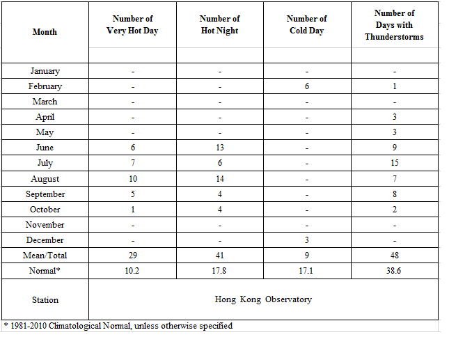
Locally, the weather in Hong Kong was warmer than usual in 2017 with an annual mean temperature of 23.9 degrees, 0.6 degree above the 1981-2010 normal[1] (or 0.9 degree above the 1961-1990 normal) and among the third warmest since records began in 1884. In particular, the monthly mean temperatures of 18.5 degrees for January and 29.0 degrees for September both ranked the highest for the respective month since records began in 1884. The daily maximum temperature of 36.6 degrees on 22 August recorded at the Hong Kong Observatory was an all-time high since records began in 1884. There were 41 Hot Nights[3] and 29 Very Hot Days[2] in Hong Kong in 2017, ranking the highest and the sixth highest on record respectively.
For low temperatures, the number of Cold Days[4] in the year was 9 days, which is 8 days less than the 1981-2010 normal. The lowest temperature recorded at the Hong Kong Observatory in the year was 9.8 degrees on 18 December.
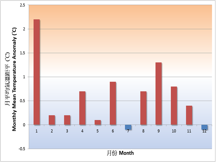
Fig. 1 Monthly mean temperature anomalies in Hong Kong in 2017
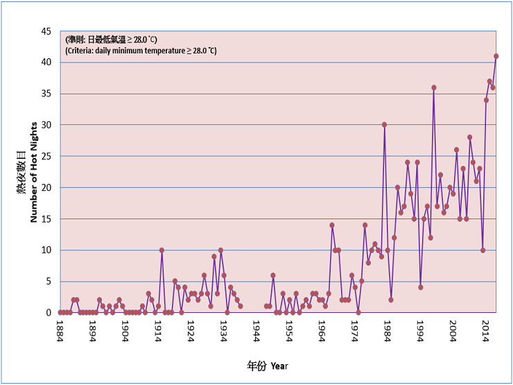
Fig. 2 Long-term time series of number of hot nights in Hong Kong 1884-2017
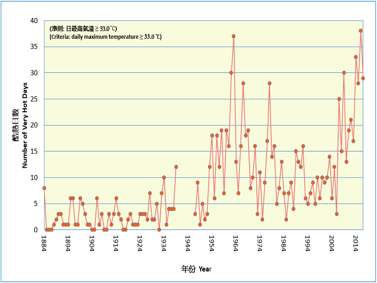
Fig. 3 Long-term time series of number of very hot days in Hong Kong 1884-2017
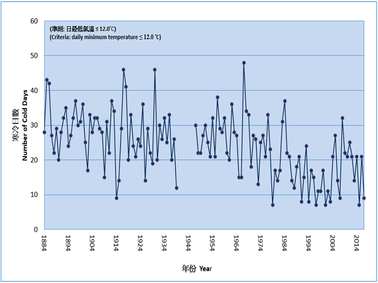
Fig. 4 Long-term time series of number of cold days in Hong Kong 1884-2017
The year 2017 brought more rain than normal in Hong Kong. The annual total rainfall was 2572.1 millimetres, a surplus of 7 percent comparing to the 1981-2010 normal of 2398.5 millimetres (or about 16 percent above the 1961-1990 normal). The number of days with thunderstorms reported in Hong Kong was 48 days in 2017, about 9 days more than the 1981-2010 normal. Affected by a trough of low pressure, torrential rain and squally thunderstorms in Hong Kong led to the issuance of the only Black Rainstorm Warning in the year on 24 May.
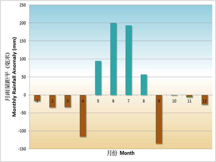
Fig. 5 Monthly rainfall anomalies in Hong Kong in 2017
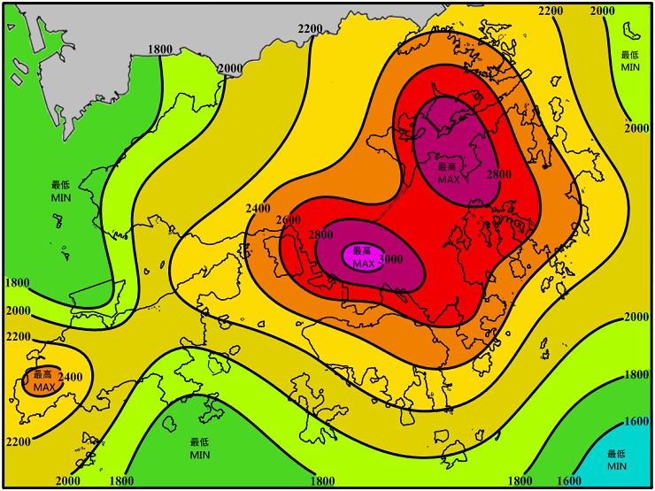
Fig. 6 Annual rainfall distribution (millimetres) in Hong Kong in 2017
A total of 32 tropical cyclones occurred over the western North Pacific and the South China Sea in 2017, more than the long-term (1961-2010) average. There were 12 tropical cyclones reaching typhoon intensity[5] or above during the year, less than the long-term average of about 15, and four of them reached super typhoon intensity (maximum 10-minute wind speed of 185 km/h or above near the centre). In Hong Kong, seven tropical cyclones necessitated the issuance of tropical cyclone warning signals, slightly higher than the long-term average of about six in a year. The Hurricane Signal No. 10 was issued during the passage of Hato in August, while the No. 8 Gale or Storm Signals was issued five times for the passages of Merbok in June, Roke in July, Hato and Pakhar in August and Khanun in October, equalling the records of 1964 and 1999.
Detailed description of the weather for individual months is available on the Monthly Weather Summary webpage:https://www.hko.gov.hk/en/wxinfo/pastwx/mws.htm
Some significant weather events in Hong Kong in 2017 are highlighted below:
Warmest January
With no significant cold surge affecting the coastal areas of Guangdong, January 2017 was the warmest January in Hong Kong with record-breaking monthly mean temperature of 18.5 degrees and monthly mean minimum temperature of 17.0 degrees, 2.2 degrees and 2.5 degrees above their respective normals.
High Temperatures in August, September and October
As Super Typhoon Hato headed towards Hong Kong, the subsidence effect ahead of its circulation brought oppressive heat to the territory on 22 August as the temperature at the Hong Kong Observatory soared to an all-time record-breaking high of 36.6 degrees.
The weather in Hong Kong was unseasonably hot in September. The monthly mean temperature of 29.0 degrees and monthly mean minimum temperature of 27.2 degrees were the highest ever on record for September, 1.3 degrees and 1.4 degrees above their respective normals.
The weather was also unseasonably hot in Hong Kong in the first half of October with one very hot day and four hot nights. It was also the first time with hot nights occurring in October since records began in 1884. The monthly mean temperature was 26.3 degrees, 0.8 degree above the normal of 25.5 degrees and the fifth highest on record for October.
A Very Active Typhoon Season
Seven tropical cyclones necessitated the issuance of tropical cyclone warning signals during the year. Five of them even necessitated the issuance of Signal No.8 or above, a joint record with the years 1964 and 1999. The active tropical cyclone season in 2017 was mainly due to warmer-than-normal sea surface temperature over the northeastern part of the South China Sea in July, August, September and November. The atmospheric pattern during these months also provided favourable steering flow for tropical cyclones to move into the South China Sea and towards southern China.
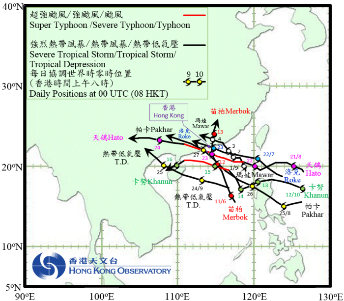
Fig. 7 Tracks of the seven tropical cyclones affecting Hong Kong in 2017
The Strike of Super Typhoon Hato
The Observatory issued the highest tropical cyclone warning, No.10 Hurricane Signal, on 23 August 2017 during the passage of Super Typhoon Hato, the first time since Severe Typhoon Vicente in July 2012. Hato momentarily attained super typhoon intensity over the sea areas south of Hong Kong, the first time since Hope in 1979 that a tropical cyclone reached super typhoon intensity during the period when tropical cyclone warning signals No.8 or above were in force in Hong Kong.
With the approach of Hato coinciding with the high water of the astronomical tide, storm surges induced by Hato resulted in serious sea water flooding and damages in many low-lying areas in Hong Kong. The water level at Quarry Bay reached a maximum of 3.57 mCD (metres above Chart Datum), the second highest since instrumental records began in 1954 and only lower than the record high of 3.96 mCD set by Super Typhoon Wanda in 1962. More details can be found in the tropical cyclone report of Super Typhoon Hato (https://www.hko.gov.hk/en/informtc/hato17/hato.htm).
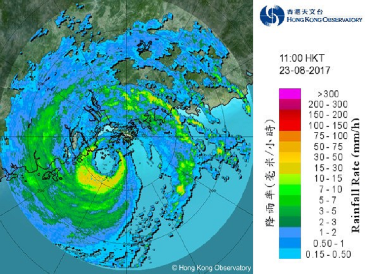
Fig. 8 Image of radar echoes at 11:00 a.m. on 23 August 2017, showing the centre of Hato to the southwest of Hong Kong.
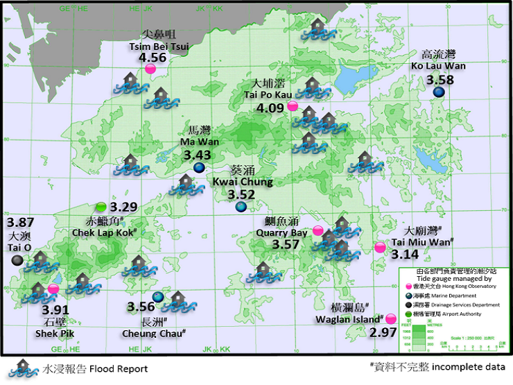
Fig. 9 Maximum sea level (metres above Chart Datum) recorded at various tide stations in Hong Kong and flood reports from government departments, news and social media on 23 August 2017.
Notes :
[1] Climatological normals for the reference period of 1961-1990, 1971-2000 and 1981-2010 are available at : https://www.weather.gov.hk/en/cis/normal.htm.
Climatological normals of 1981-2010 are referenced in the text unless otherwise stated.
[2] 'Very Hot Day' refers to the condition with the daily maximum temperature equal to or higher than 33.0 degrees.
[3] 'Hot Night' refers to the condition with the daily minimum temperature equal to or higher than 28.0 degrees.
[4] 'Cold Day' refers to the condition with the daily minimum temperature equal to or lower than 12.0 degrees.
[5] Information on the classification of Tropical Cyclones is available at: https://www.hko.gov.hk/en/informtc/class.htm
Table 1 Summary of record-breaking high temperature events in 2017
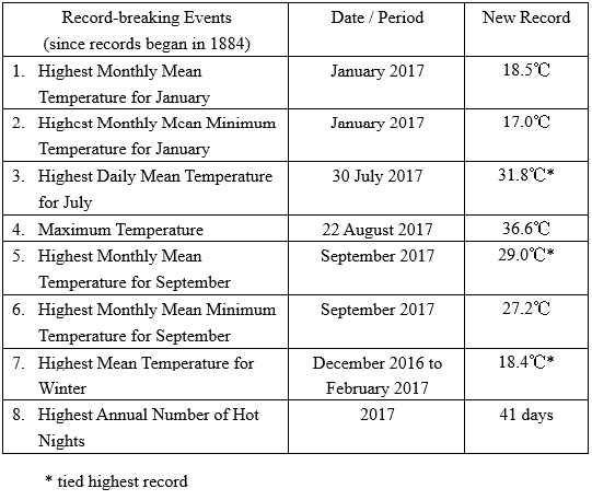
Table 2a Summary of meteorological observations in Hong Kong, 2017
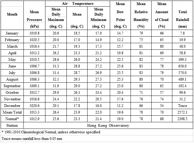
Table 2b Summary of meteorological observations in Hong Kong, 2017
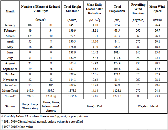
Table 2c Summary of meteorological observations in Hong Kong, 2017
