Skip Content

Super Typhoon Hato (1713)

Super Typhoon Hato (1713)
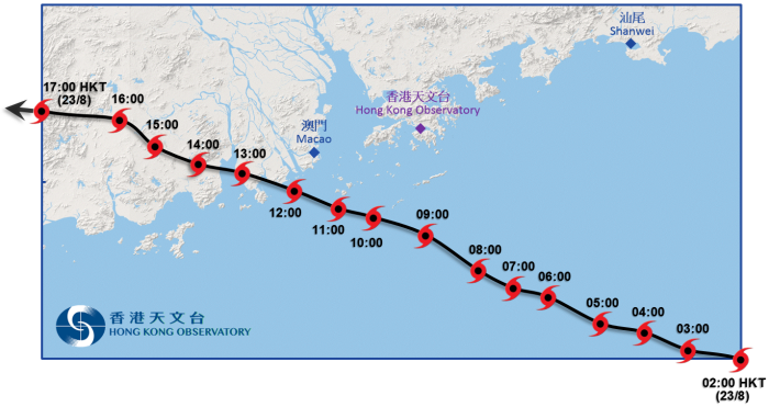
20 to 24 August 2017
Wednesday, 25th October 2017
Track of Hato near Hong Kong
 

*

Report on Super Typhoon Hato

Figures

*

Track of Hato: 20 – 24 August 2017

*

Track of Hato near Hong Kong

*

Time series of the maximum sustained wind speed near the centre of Hato

*

Rainfall distribution on 22 - 24 August 2017

*

10-minute mean wind direction and speed recorded at various stations in Hong Kong at 10 a.m. on 23 August 2017

*

10-minute mean wind direction and speed recorded at various stations in Hong Kong at 11 a.m. on 23 August 2017

*

Traces of 10-minute wind speed at Cheung Chau, Hong Kong International Airport and North Point on 23 August 2017

*

Traces of mean sea-level pressure recorded at the Hong Kong Observatory, Cheung Chau and Hong Kong International Airport on 22 and 23 August 2017

*

Maximum sea level recorded at various tide stations in Hong Kong and flood reports from government departments, news and social media on 23 August 2017

*

Traces of sea level and storm surge recorded at Quarry Bay, Tai Po Kau, and Tsim Bei Tsui on 22 and 23 August 2017

*

Visible satellite imagery around 11 a.m. on 23 August 2017

*

Image of radar echoes at 10:00 a.m. on 23 August 2017 when Hato was closest to the Hong Kong Observatory Headquarters

*

Image of cloud top height estimated using radar data at 7 a.m. on 23 August 2017, overlaid with lightning locations during the past 30 minutes

Damages brought by Hato in Hong Kong

*

Fallen trees

*

High waves

*

Shattered glass curtain walls

*

Flooding and damage caused by storm surge

Heng Fa Chuen and Siu Sai Wan

Tai O

Shing Mun River in Sha Tin and coastal area of Tolo Harbour

Yuen Long

Tseung Kwan O and Cheung Chau

*

Vessels in distress

Video

Sea water flowing into an underground car park in Heng Fa Chuen

Sea water flowing into Heng Fa Chuen

*

Damages brought by Hato in Macao

Tables

*

Maximum gust peak speeds and maximum hourly mean winds with associated wind directions recorded at various stations when the tropical cyclone warning signals for Hato were in force

*

Periods during which sustained strong and gale force winds were attained at the eight reference anemometers when tropical cyclone warning signals for Hato were in force

*

Daily rainfall amounts recorded at the Hong Kong Observatory Headquarters and other stations during the passage of Hato

*

Times and heights of the maximum sea level and the maximum storm surge recorded at tide stations in Hong Kong during the passage of Hato

Animation

*

Radar image animation of Super Typhoon Hato

*

Infra-red satellite image animation of Super Typhoon Hato