Lightning Location Information Service
Introduction :
In 2005, the Hong Kong Observatory set up a lightning location system in cooperation with the Guangdong Meteorological Service and Macao Meteorological and Geophysical Bureau. The system monitors lightning activities over the Pearl River Delta round the clock and disseminates the lightning information through various channels, providing different types of lightning location information service to the public and various users.
Working principle of the lightning location system :
Lightning is formed by severe turbulence inside a cumulonimbus cloud. The water droplets and ice crystals in the cloud break up and produce positive and negative electric charges. When the electric voltage is high enough, discharges take place between cloud and ground or between clouds. Besides lighting up the sky and producing a thunderous clap, the strong electric current in the discharge generates electromagnetic waves which spread in all directions.
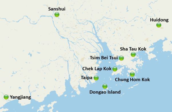
Figure 1. Distribution of lightning sensor stations of the lightning location network
The Observatory's lightning location system comprises nine lightning sensor stations located at Chung Hom Kok, Tsim Bei Tsui, Sha Tau Kok and Chek Lap Kok in Hong Kong, Sanshui, Huidong, Yangjiang and Dongao Island in Guangdong, as well as Taipa in Macao (Figure 1). Each sensor station is equipped with special antenna and instrument (Figure 2), capable of receiving the electromagnetic waves generated by lightning. As the sensor stations are at different locations, the electromagnetic waves from the same lightning stroke reach the stations in different times and directions, thereby allowing the originating location of the lightning to be computed by the system. The system is also capable of distinguishing between cloud-to-ground and cloud-to-cloud lightning by analysing the waveform characteristics of the electromagnetic waves.
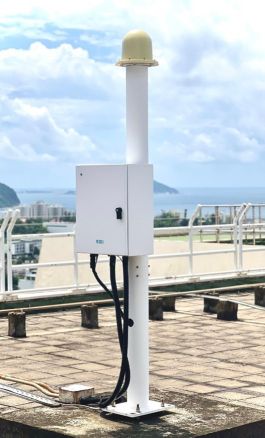
Figure 2. Lightning sensor at Chung Hom Kok
Lightning location information service :
The Observatory provides lightning location information service to the public through various channels. Among them, the Observatory’s Lightning Location Information Service webpage displays the past half-an-hour lightning locations via geographical information imagery in real-time (Figure 3). The information is updated every five minutes, such that users can better understand the lightning situations over the vicinity of the Pearl River Estuary.
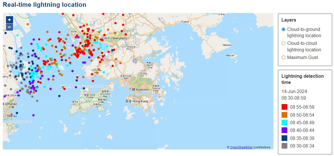
Figure 3. Lightning location map on the Lightning Location Information Service webpage
Cloud-to-ground lightning strokes may affect people or facilities outdoor. The Observatory’s Location-specific Lightning Alert Webpage enables users specifying a location and its alert region (Figure 4). When lightning strokes are detected within the alert region, the webpage will prompt an alert reminding users the lightning situations nearby. In addition to providing different local outdoor activity locations, including country parks, swimming pools, and sports grounds, etc, for selection, the webpage also allows users setting the length of lightning detection periods and radar images to facilitate a better understanding of the change of adverse weather for planning ahead.
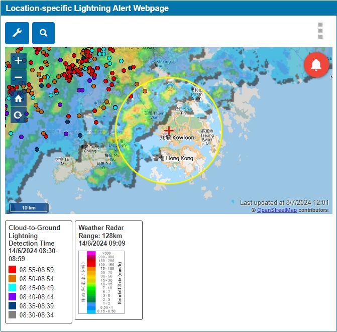
Figure 4. Location-specific Lightning Alert Webpage
Besides the Observatory’s webpages, members of the public can obtain the latest lightning information through the mobile application "MyObservatory", or the Observatory's Dial-a-Weather service (1878 200, press 327). The Observatory also delivers relevant lightning information to the public through radio and television.
Past lightning data :
The Observatory’s website also provides information of the recent cloud-to-ground lightning count distribution over Hong Kong (Figure 5), number of lightning strokes detected over the Hong Kong territory today and for the past three days (Figure 6), as well as map of past lightning density in Hong Kong, in which members of the public can easily look up.
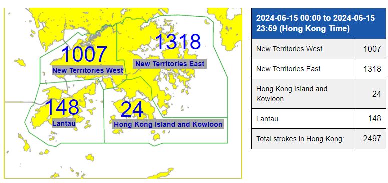
Figure 5. Information of the recent cloud-to-ground lightning count distribution over Hong Kong
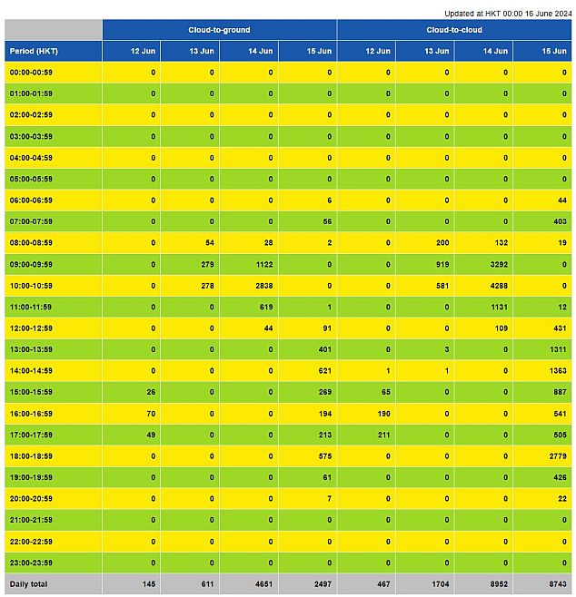
Figure 6. Information of the number of lightning strokes detected over the Hong Kong territory today and for the past three days
If members of the public need more detailed lightning data of the past, they can contact the Climatological Services division of the Observatory which provides the service on a cost-recovery basis.
Other relevant information :
The "Thunderstorm Warning" pamphlet published by the Observatory and its webpage provide details about thunderstorm warning. Some scientific facts about thunderstorms are available in the Observatory's Education Resources webpages and Announcement in the Public Interest.