Tropical Cyclones in 2018 > Figure 3.5.7

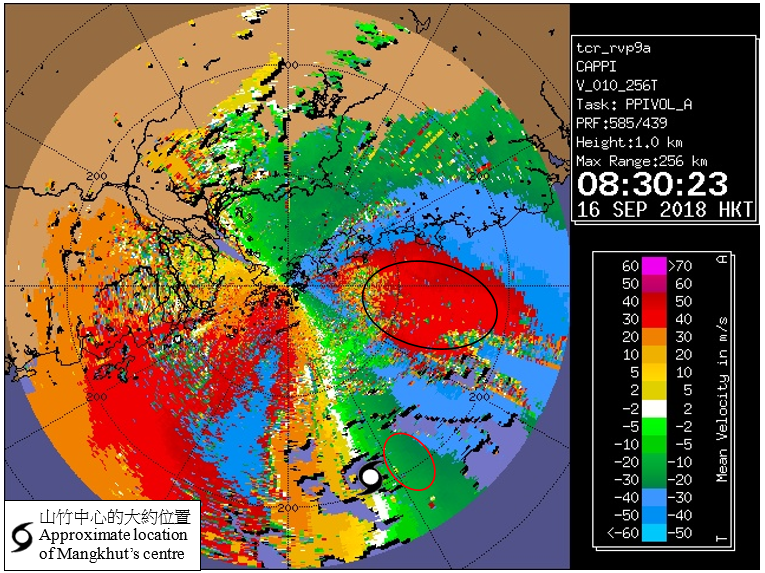
Figure 3.5.7 Radar imagery showing the Doppler velocity at 8:30 a.m. on 16 September 2018. The image revealed the radial winds at 1 km (i.e. the velocity of rain echoes relative to the radar, and positive (negative) values indicates rain echoes moving away from (towards) the radar). The image showed that the radial wind over the outer spiral rainband was higher than that near the eyewall.
Note: Please note the constraint of the range of the velocity detected by Doppler radar. The maximum detectable speed is called Nyquist velocity. The Nyquist velocity of Tate’s Cairn Weather Radar is 45.1 m/s. If the radial wind exceeds the Nyquist velocity, there will be velocity folding, and the radial speed will change from positive (negative) 45.1 m/s to negative (positive) 45.1 m/s. Using the spiral rainband of Mangkhut (circled in black) as an example, the radial wind read directly from the figure ranged between +30 and +40 m/s (positive value means moving away from radar). In fact the rain echoes were moving towards the radar. After adjusting for the folding, the actual radial wind of the rain echoes at a height 1 km should range from –50.1 m/s to –60.1 m/s. In contrast, there was no velocity folding of the rain echoes near the eyewall (circled in red), and the radial wind ranged between –20 and –30 m/s. |