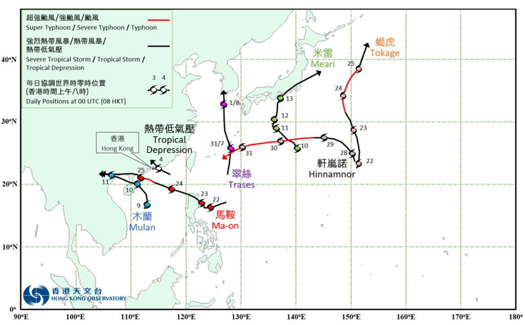
Overview of Tropical Cyclone in August 2022
|
Seven tropical cyclones occurred over the western North Pacific and the South China Sea in August 2022. Among them, the tropical depression over the northeastern part of the South China Sea, Mulan and Ma-on necessitated the issuance of the tropical cyclone warning signals by the Observatory. Trases formed as a tropical depression over the western North Pacific about 510 km south of Okinawa on the afternoon of 30 July. It moved northwards towards the vicinity of the Ryukyu Islands and intensified gradually. Trases intensified into a tropical storm on the morning of 31 July and reached its peak intensity with an estimated maximum sustained wind of 65 km/h near its centre. It then moved across the East China Sea and weakened gradually. Trases finally degenerated into an area of low pressure over the Korean Peninsula on 1 August. A tropical depression formed over the northeastern part of the South China Sea about 310 km east-southeast of Hong Kong on the night of 3 August. It tracked west-northwestwards towards the east of the Pearl River Estuary with an estimated maximum sustained wind of 45 km/h near its centre. The tropical depression made landfall over the coast of Huidong on the morning of 4 August and degenerated into an area of low pressure over inland Guangdong after noon. For detailed information of the tropical depression including its impact to Hong Kong, please refer to its Tropical Cyclone Report. Mulan formed as a tropical depression over the central part of the South China Sea about 700 km south-southwest of Hong Kong in the small hours on 9 August. It moved north to north-northeastwards at first. Mulan intensified into a tropical storm in the afternoon and reached its peak intensity with an estimated maximum sustained wind of 65 km/h near its centre. It turned to move northwestwards on the night of 9 August. Mulan skirted past the northeastern part of Hainan Island and the southern part of Leizhou Peninsula on 10 August and moved across Beibu Wan at night. It made landfall over the northern part of Vietnam and weakened into an area of low pressure over inland on 11 August. For detailed information of Mulan including its impact to Hong Kong, please refer to the Tropical Cyclone Report of Mulan. Meari formed as a tropical depression over the western North Pacific about 140 km northwest of Iwo Jima on the morning of 10 August. It moved northwestwards and intensified gradually. Meari intensified into a tropical storm on the night of 11 August and generally tracked northwards towards Honshu, Japan. Meari reached its peak intensity on the night of 12 August with an estimated maximum sustained wind of 75 km/h near its centre. It moved northeastwards and skirted past the southern coast of Honshu, Japan on the next day and finally evolved into an extratropical cyclone over the seas east of Japan on 14 August. According to press reports, Meari brought torrential rain and squalls to Japan which caused about 10 000 households without electricity supply during its passage. Ma-on formed as a tropical depression over the western North Pacific about 730 km east-northeast of Manila on the afternoon of 21 August. It moved west-southwestwards and intensified gradually. Ma-on turned to track west-northwestwards on 22 August and developed into a severe tropical storm in the small hours on 23 August. It moved across the northern part of Luzon that day and entered the northern part of the South China Sea at night. Ma-on tracked west-northwestwards and moved rapidly across the northern part of the South China Sea towards the coast of western Guangdong the next day. Ma-on further developed into a typhoon that night, reaching its peak intensity with an estimated maximum sustained wind of 120 km/h near its centre. Affected by relatively strong vertical wind shear over the northern part of the South China Sea, Ma-on weakened gradually afterwards. It made landfall near Dianbai, Maoming before noon on 25 August and finally weakened into an area of low pressure over the northern part of Vietnam on 26 August. According to press reports, the rail and shipping services in Zhuhai were suspended under the influence of the torrential rain and squalls associated with Ma-on. For detailed information of Ma-on including its impact to Hong Kong, please refer to the Tropical Cyclone Report of Ma-on. Tokage formed as a tropical depression over the western North Pacific about 1 020 km east of Iwo Jima in the small hours of 22 August. It generally tracked northwards and intensified gradually. Tokage intensified into a typhoon on the night of 23 August and reached its peak intensity in the small hours on 24 August with an estimated maximum sustained wind of 145 km/h near its centre. It then weakened gradually and finally evolved into an extratropical cyclone over the western North Pacific to the east of Japan on 25 August. Hinnamnor formed as a tropical depression over the western North Pacific about 960 km east of Iwo Jima in the small hours on 28 August. It generally moved northwestwards and intensified gradually. On 29 August, Hinnamnor tracked westwards towards the vicinity of the Ryukyu Islands and intensified rapidly. Hinnamnor developed into a super typhoon on the morning of 30 August. It gradually turned to move southwestwards towards the seas east of Taiwan the next day. |

Provisional Tropical Cyclone Tracks in August 2022