Overview of Tropical Cyclones in October 2018
- Overview of Tropical Cyclones in October 2018
- Monday, 10th December 2018
|
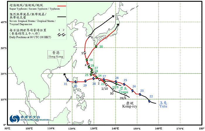
Three tropical cyclones occurred over the western North Pacific and the South China Sea in October 2018, of which Yutu necessitated the issuance of the tropical cyclone warning signals by the Hong Kong Observatory. Trami which formed on 21 September evolved into an extratropical cyclone over the northern part of Honshu, Japan on 1 October. Please refer to the overview in September 2018 for the detailed information of Trami. Kong-rey formed as a tropical depression over the western North Pacific about 370 km south-southeast of Guam on the early morning of 29 September. Moving west-northwestwards, it intensified rapidly. Kong-rey developed into a typhoon on the night of 30 September and further intensified into a super typhoon the next night, reaching its peak intensity on the afternoon of 2 October with an estimated maximum sustained wind of 220 km/h near its centre. It started to weaken on 3 October and continued to move towards the vicinity of the Ryukyu Islands. Kong-rey moved across Jeju and the southern part of the Korean Peninsula on 5 and 6 October. It finally evolved into an extratropical cyclone in the vicinity of Hokkaido on 7 October. According to press reports, Kong-rey brought torrential rain and squalls to Japan, with at least one people killed and 10 people injured. Electricity supply to more than 40 000 households was interrupted in Okinawa and Kagoshima Prefectures. At least two people were killed and one was missing in the Republic of Korea during the passage of Kong-rey, and electricity supply to more than 60 000 households was interrupted. Yutu formed as a tropical depression over the western North Pacific about 1 620 km east-southeast of Guam on the afternoon of 21 October. Tracking generally northwestwards, it intensified rapidly. Yutu developed into a super typhoon on 24 October, reaching its peak intensity the next day with an estimated maximum sustained wind of 250 km/h near its centre. Yutu turned to move west to west-southwestwards on 26 and 27 October and started to weaken gradually. After moving across Luzon on 30 October, Yutu entered the central part of the South China Sea and weakened into a typhoon. Yutu further weakened into a severe tropical storm on the next day and turned to move northwestwards across the northeastern part of the South China Sea. |

Provisional Tropical Cyclone Tracks in October 2018