Overview of Tropical Cyclones in September 2018
Overview of Tropical Cyclones in September 2018
Thursday, 15th November 2018
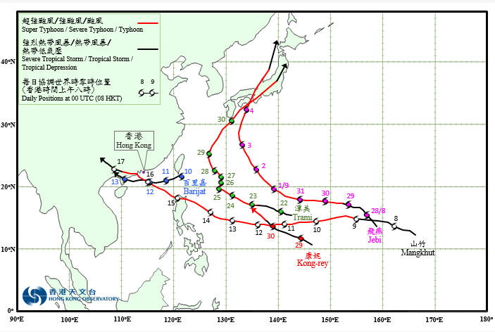
Five tropical cyclones occurred over the western North Pacific and the South China Sea in September 2018, of which Barijat and Mangkhut necessitated the issuance of the tropical cyclone warning signals by the Observatory. No.10 Hurricane Signal was issued during the passage of Mangkhut on 16 September.
Jebi formed as a tropical depression over the western North Pacific about 1 520 km east of Guam on the night of 27 August. It tracked northwestwards at first and intensified rapidly. Jebi intensified into a typhoon on 29 August and turned to move westwards. It further developed into a super typhoon on 31 August, reaching its peak intensity on the morning of 1 September with an estimated maximum sustained wind of 230 km/h near its centre. Jebi’s track turned gradually from northwestwards to northwards and edged closer to the sea areas south of Japan in the next two days when it weakened into a severe typhoon. It swept across the eastern part of Shikoku, Osaka Bay and Kansai of Honshu during the day of 4 September. It evolved into an extratropical cyclone over the seas west of Hokkaido the next day.
According to press reports, the torrential rain and squalls brought by Jebi wreaked havoc to Japan, with at least 11 people killed, 680 people injured. Electricity supply to more than 2 million households was interrupted. Record-breaking water levels were registered in the vicinity of Osaka because of the severe storm surge induced by Jebi, resulting in serious flooding over the coastal regions. The Kansai international airport was fully closed for more than two days because of serious inundation, forcing over 5 000 passengers to stay at the airport.
Barijat formed as a tropical depression over the sea areas about 200 km southeast of Gaoxiong on the morning of 10 September and moved generally westwards across the northern part of the South China Sea. It intensified into a tropical storm on 11 September and reached its peak intensity with an estimated maximum sustained wind of 85 km/h near its centre the next night. Barijat moved across Leizhou Peninsula and weakened on 13 September. It dissipated over inland Guangxi in that evening.
According to press reports, 40 000 people were evacuated in Maoming and Zhanjiang during the passage of Barijat. For detailed information of Barijat including its impact to Hong Kong, please refer to the Tropical Cyclone Report of Barijat.
Tropical depression Mangkhut formed over the western North Pacific about 2 330 km east of Guam on 7 September. Moving westwards rapidly, it intensified gradually in the following few days. Mangkhut developed into a super typhoon on 11 September. It turned to move northwest on 14 September, reaching its peak intensity before making landfall over Luzon with an estimated maximum sustained wind of 250 km/h near the centre. Mangkhut weakened after crossing the northern part of Luzon and continued to track northwestwards quickly across the northern part of the South China Sea, edging towards the coast of Guangdong. Mangkhut weakened into a severe typhoon on the morning of 16 September and made landfall over the vicinity of Taishan of Guangdong before dusk. It then moved into western part of Guangdong and weakened further. Mangkhut degenerated into an area of low pressure over Guangxi the next night.
According to press reports, Mangkhut brought torrential rain and squalls to Luzon. There were at least 82 deaths, 138 injuries and two missing. Around 15 000 houses were collapsed. Mangkhut brought damaging winds and severe storm surge to the coast of Pearl River estuary, leading to damages of many buildings and coastal structures, as well as serious inundation of low lying areas. In Macao, 40 people were injured and more than 5 500 people were evacuated. There were a number of reports of building damages. The water level of Inner Harbour was 1.9 metres or higher. At least six people were killed and more than 3.3 million were affected in Guangdong, Guangxi, Hainan, Guizhou and Yunnan. Mangkhut brought fierce winds and record-breaking storm surge to Hong Kong. For detailed information of Mangkhut and the extensive damages that it brought to Hong Kong, please refer to the Tropical Cyclone Report of Mangkhut which will be issued later.
Trami formed as a tropical depression over the western North Pacific about 320 km northwest of Guam on the night of 21 September. It tracked generally west-northwestwards and intensified rapidly. Trami developed into a typhoon on 23 September and further intensified into a super typhoon the next day, reaching its peak intensity in the small hours of 25 September with an estimated maximum sustained wind of 220 km/h near its centre. Trami turned to move slowly on a north-northeasterly course on the night of 25 September and started to weaken. It moved towards the vicinity of the Ryukyu Islands gradually in the following days. After skirting past Okinawa on 29 September, Trami took on a northeast course towards Honshu of Japan. It skirted past Honshu of Japan during the night of 30 September and evolved into an extratropical cyclone over the northern part of Honshu the next day.
According to press reports, Trami left at least five deaths with one missing and 200 injured during its passage to Japan. Electricity supply to more than 1.3 million households was interrupted. Transportation services in Japan were paralyzed, affecting more than 100 000 passengers.
Kong-rey formed as a tropical depression over the western North Pacific about 370 km south-southeast of Guam on the early morning of 29 September. Moving west-northwestwards, it intensified rapidly. Kong-rey developed into a typhoon on the night of 30 September and moved towards the vicinity of the Ryukyu Islands.
 |
|---|
Provisional Tropical Cyclone Tracks in September 2018