Overview of Tropical Cyclones in October 2017
Overview of Tropical Cyclones in October 2017
Wednesday, 6th December 2017
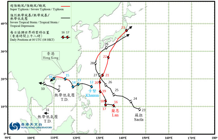
Five tropical cyclones occurred over the western North Pacific and the South China Sea in October 2017, of which Khanun necessitated the issuance of No.8 Gale or Storm Signals by the Observatory for the fifth time this year, a joint record with 1964 and 1999 in terms of the number of No.8 Signals issued in a year.
A tropical depression formed over the central part of the South China Sea about 100 km south of Xisha on the morning of 9 October. It tracked west-northwestwards with an estimated sustained wind of 45 km/h near its centre. The tropical depression made landfall over the northern part of Vietnam the next morning and weakened into an area of low pressure. According to press reports, torrential rain induced by the tropical depression caused severe flooding and landslides in Vietnam, resulting in at least 72 deaths.
Khanun formed as a tropical depression over the western North Pacific about 650 km east-northeast of Manila on the morning of 12 October. It moved west-northwestwards and intensified into a tropical storm that night. Khanun moved across the northern part of Luzon the next day and drifted west-southwestwards slowly as it re-organized after entering the South China Sea. It turned northwestwards on 14 October and then west-northwestwards the next day as it approached the south China coast, intensifying into a severe typhoon and reaching its peak intensity with an estimated sustained wind of 155 km/h near its centre. It then started to weaken rapidly and moved across Leizhou Peninsula in the early morning on 16 October, degenerating into an area of low pressure over Beibu Wan during the day.
According to press reports, at least seven people were injured in Macao during the passage of Khanun. Transportation services were seriously disrupted. Under the combined influence of Khanun and the northeast monsoon, at least 970 000 people were affected in Guangdong, Hainan, Zhejiang, Guangxi and Fujian. There was also widespread heavy rain in Taiwan, with roads damaged and electricity supply to 14 000 households disrupted. For detailed information of Khanun including its impact on Hong Kong, please refer to the Tropical Cyclone Report of Khanun.
Lan formed as a tropical depression over the western North Pacific about 160 km west-northwest of Yap in the morning on 16 October and moved generally westwards during the day. It started to take on a north to north-northwestward track in the general direction of the sea areas east of Ryukyu Islands on 17 – 20 October and continued to intensify. It developed into a super typhoon on 21 October and reached its peak intensity with an estimated sustained wind of 205 km/h near its centre. Lan then accelerated to the north-northeast towards Japan and weakened gradually. It swept across the eastern part of Honshu on the early morning of 23 October before evolving into an extratropical cyclone over the sea areas east of Japan during the day.
According to press reports, at least seven persons were killed and more than 130 people injured in Japan during the passage of Lan. Hundreds of houses were damaged and electricity supply to around 130 000 households was disrupted.
Saola formed as a tropical depression over the western North Pacific about 570 km south-southeast of Guam on the morning of 23 October. It moved generally to the west-northwest and northwest over the next few days before turning northwards on the night of 27 October. It swept across Ryukyu Islands the next day and intensified into a typhoon, reaching its peak intensity with an estimated sustained wind of 120 km/h near its centre. Turning to the northeast, Saola accelerated and skirted past to the south of Japan on 29 October. It finally evolved into an extratropical cyclone over the sea areas east of Japan during the night.
According to press reports, at least six people were injured in Japan during the passage of Saola. Electricity supply to nearly 30 000 households was disrupted.
A tropical depression formed over the southern part of the South China Sea about 390 km south-southeast of Ho Chi Minh City on the night of 31 October and tracked generally westwards. Further development of the tropical depression will be described in the Overview of Tropical Cyclones in November 2017.
 |
|---|
Tropical Cyclone Tracks in October 2017