Overview of Tropical Cyclones in November 2017
Overview of Tropical Cyclones in November 2017
Wednesday, 3rd January 2018
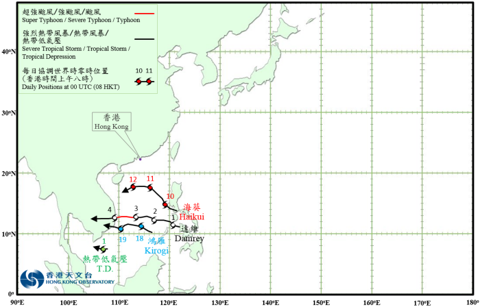
There were four tropical cyclones over the western North Pacific and the South China Sea in November 2017.
A tropical depression formed over the sea areas south of Vietnam about 390 km south-southeast of Ho Chi Minh City on the night of 31 October. It tracked slowly westwards in general with an estimated maximum sustained wind of 45 km/h near its centre. The tropical depression weakened into an area of low pressure early in the morning on 2 November over the sea areas south of Vietnam.
Damrey formed as a tropical depression near the Philippines about 400 km south-southeast of Manila in the early morning on 1 November. Moving generally westwards, it crossed the southern part of the South China Sea and intensified gradually. Damrey developed into a typhoon on the afternoon of 3 November and reached its peak intensity the next morning with an estimated maximum sustained wind of 140 km/h near its centre. It made landfall over the southern part of Vietnam on the morning of 4 November and weakened rapidly into an area of low pressure over Cambodia that night.
According to press reports, Damrey left at least 89 people dead, 174 injured and 18 missing in Vietnam during its passage. Over 2000 houses were damaged. The heavy rain associated with the remnant low pressure area of Damrey triggered severe flooding in many places of Penang, Malaysia, leading to at least 6 deaths and the evacuation of over 3000 people.
Haikui formed as a tropical depression near the Philippines about 100 km south-southeast of Manila on the night of 9 November. Moving northwestwards into the South China Sea, it intensified gradually. Haikui started to turn westwards on 11 November and developed into a severe tropical storm that afternoon, reaching its peak intensity with an estimated maximum sustained wind of 90 km/h near its centre. It weakened rapidly the next day and degenerated into an area of low pressure over the central part of the South China Sea in the afternoon.
Kirogi formed as a tropical depression over the southern part of the South China Sea about 240 km east of Nansha Dao on the night of 17 November. It moved generally westwards in the direction of Vietnam. Kirogi intensified into a tropical storm the next day, reaching its peak intensity with an estimated maximum sustained wind of 65 km/h near its centre. It started to weaken on 19 November, making landfall over the southern part of Vietnam and degenerating into an area of low pressure in the afternoon.
 |
|---|
Provisional Tropical Cyclone Tracks in November 2017