Overview of Tropical Cyclones in September 2014
(Tracks)
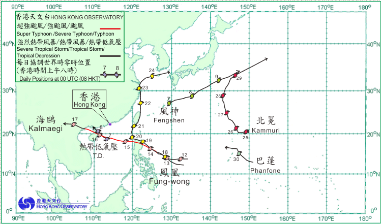
Six tropical cyclones occurred over the western North Pacific and the South China Sea in September 2014. Amongst them, a tropical depression and Typhoon Kalmaegi necessitated the issuance of tropical cyclone warning signals in Hong Kong.
A tropical depression formed over the northern part of the South China Sea about 340 km east-southeast of Haikou on the morning of 7 September. Taking a northwesterly track towards western Guangdong and the Leizhou Peninsula, it reached peak intensity that afternoon with an estimated sustained wind of 55 km/h near its centre. The tropical depression made landfall near Zhanjiang on the afternoon of 8 September and weakened into an area of low pressure over the Leizhou Peninsula that night.
Another tropical depression formed over the western North Pacific about 210 km east-northeast of Okinawa on the morning of 7 September. Drifting east-northeastwards, it developed into a tropical storm named Fengshen that afternoon. Fengshen intensified further into a severe tropical storm the next morning, reaching peak intensity with an estimated maximum sustained wind of 105 km/h near its centre. Maintaining an east-northeasterly track, Fengshen moved across the seas south of Japan and weakened gradually. It became an extratropical cyclone on the night of 9 September.
Kalmaegi formed as a tropical depression over the western North Pacific about 1430 km east of Manila on the morning of 12 September. It moved west-northwestwards and intensified gradually into a typhoon. Kalmaegi moved across the northern part of Luzon on the night of 14 September and maintained a good pace after entering the South China Sea the next morning. It reached peak intensity with an estimated sustained wind of 140 km/h near its centre before making landfall near Wenchang over the northeastern part of Hainan Island on the morning of 16 September. After crossing Beibu Wan in the afternoon, Kalmaegi made landfall over the northern part of Vietnam that night. Moving inland and weakening gradually, it finally became an area of low pressure over Yunnan on the afternoon of 17 September.
According to press reports, Kalmaegi wreaked havoc in Hainan Island, western Guangdong and Guangxi, resulting in at least three deaths, one missing and about 6 million people affected. Transportation services were suspended. Storm surge triggered by Kalmaegi caused backflow of sea water in coastal areas, resulting in severe flooding in some areas. Sea level at Haikou was the highest since record began in 1973.
Fung-wong formed as a tropical depression over the western North Pacific about 1340 km east of Manila on the afternoon of 17 September. Moving northwestwards, Fung-wong intensified into a tropical storm the next morning. It skirted past the northern part of Luzon on 19 September and turned northwards across Luzon strait. It intensified into a severe tropical storm the next morning, reaching peak intensity with an estimated sustained wind of 90 km/h near its centre. Fung-wong reached the southern part of Taiwan on the morning of 21 September and moved along the east coast of Taiwan. It weakened into a tropical storm the next morning. After skirting past the coast of eastern China on 23 September, it turned east-northeastward and became an extratropical cyclone over the seas south of the Korean Peninsula the next morning.
According to press reports, at least 17 people were killed and several hundred houses were damaged in the Philippines during the passage of Fung-wong. Torrential rain associated with Fung-wong also triggered extensive landslides and flooding in Taiwan, causing at least four deaths and more than a hundred flights disrupted. According to preliminary estimates, economic losses in Zhejiang Province as a result of Fung-wong were around HK$800 million.
Kammuri formed as a tropical depression over the western North Pacific about 920 km northeast of Guam on the morning of 24 September and moved slowly westwards. It intensified into a tropical storm the next morning. Kammuri started to take a north-northwesterly track towards the seas south of Japan on the morning of 26 September and intensified into a severe tropical storm on the early morning 27 September, reaching peak intensity with estimated sustained winds of 90 km/h near its centre. Kammuri turned northeastwards that night and became an extratropical cyclone over the seas east of Japan on 29 September.
Phanfone formed as a tropical depression over the western North Pacific about 810 km east of Guam on the morning of 29 September and tracked northwestwards in the general direction of Ryukyu Islands and the seas south of Japan. Phanfone developed into a severe tropical storm the following night and continued to intensify.
 |
|---|
Tropical cyclone tracks in September 2014