Overview of Tropical Cyclones in August 2014
(Tracks)
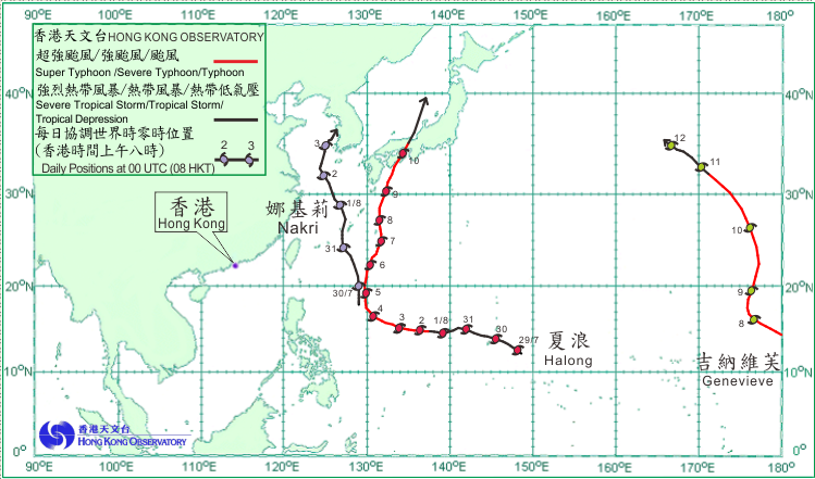
Three tropical cyclones occurred over the western North Pacific and the South China Sea in August 2014.
Halong formed as a tropical depression over the western North Pacific about 440 km east-southeast of Guam on the morning of 29 July and moved west-northwestwards. It intensified into a severe tropical storm the next morning and continued to move generally westwards in the direction of the sea areas east of the Philippines. Halong became a super typhoon on the night of 2 August and reached its peak intensity the next morning with estimated sustained winds of 230 km/h near its centre. Turning northwards on 4 August, Halong weakened into a severe typhoon as it moved over the seas east of Ryukyu Islands in the following few days. Halong crossed the western part of Japan on 10 August and further weakened into a severe tropical storm before becoming an extratropical cyclone over the Sea of Japan the next morning. According to press reports, at least ten people were killed, 96 injured and two reported missing in Japan during the passage of Halong. More than 470 flights were cancelled.
Nakri formed as a tropical depression over the western North Pacific about 930 km east-northeast of Manila on the afternoon of 29 July. Moving generally northwards and intensifying into a tropical storm, it swept past the Ryukyu Islands and headed towards the East China Sea on 31 July. Nakri intensified further into a severe tropical storm on the morning of 1 August, reaching its peak intensity with estimated sustained winds of 105 km/h. It moved across the East China Sea in the next couple of days and weakened gradually, before becoming an extratropical cyclone over the northern part of the Yellow Sea on the morning of 4 August. According to press reports, Nakri brought torrential rain to Shikoku of Japan, triggering flooding and landslides, and around 450 000 people had to be evacuated.
Having formed over the eastern North Pacific, Super Typhoon Genevieve tracked westwards crossing the International Date Line and entered the western North Pacific on 7 August. Genevieve reached its peak intensity the next morning with estimated sustained winds of 230 km/h near its centre and turned northwards. Drifting northwestwards and weakening gradually, Genevieve dissipated over the sea areas north of Wake Island on the morning of 12 August.
 |
|---|
Tropical cyclone tracks in August 2014