Overview of Tropical Cyclones in July 2014
(Tracks)
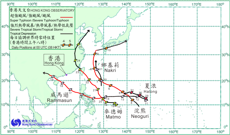
Five tropical cyclones occurred over the western North Pacific and the South China Sea in July 2014. Rammasun was the only one necessitating the issuance of the tropical cyclone warning signals by the Observatory.
Neoguri formed as a tropical depression over the western North Pacific about 470 km south of Guam on 3 July and generally moved northwestwards. It continued to develop in the next few days and intensified into a super typhoon on 7 July to the south-southeast of Okinawa, reaching its peak intensity with estimated sustained winds of 195 km/h near its centre. It turned northwards on 8 July, crossing the Ryukyu Islands and weakening into a severe typhoon. Following another turn to the east-northeast the next day, Neoguri finally made landfall over the coast of Kagoshima Prefecture on the morning of 10 July. Weakening further into a tropical storm, it skirted past the south coast of Kyushu and Honshu before becoming an extratropical cyclone over the seas east of Honshu the next morning.
According to press reports, at least seven people were killed, more than 50 injured and over 500 000 people evacuated in Japan during the passage of Neoguri. There were also interruptions of electricity supply to at least 86 000 households in Okinawa Prefecture. More than 190 flights were cancelled.
Rammasun formed as a tropical depression over the western North Pacific about 410 km east-southeast of Guam on the morning of 11 July. It intensified gradually and moved westwards steadily in the following few days. Rammasun developed into a severe typhoon and turned west-northwestwards on 15 and 16 July, moving across the central part of the Philippines and entering the South China Sea. After weakening over terrain, Rammasun re-organized over the South China Sea and intensified into a super typhoon on 18 July, reaching its peak intensity with an estimated sustained wind of 210 km/h near its centre. Tracking northwestwards, it made landfall near Wenchang over the northern part of Hainan Island later that day and crossed the coast of Guangxi the next morning. Rammasun weakened over land and became an area of low pressure over Yunnan on 20 July.
According to press reports, at least 98 people were killed, five were missing and 630 others were injured in the Philippines during the passage of Rammasun. Rammasun also wreaked havoc in Hainan Island, western Guangdong and Guangxi. At least 18 people were killed, 37 000 houses collapsed, with 7.4 million people affected.
Matmo formed as a tropical depression over the western North Pacific about 280 km west-northwest of Yap on the morning of 17 July. Moving slowly westwards initially, it turned northwestwards on 19 July and intensified into a typhoon that night. It continued to intensify and reached its peak intensity with estimated sustained winds of 140 km/h near its centre on the morning of 22 July. Matmo moved across Taiwan on the morning of 23 July and weakened into a severe tropical storm during the day. It made landfall near Fuqing of Fujian that evening and weakened further into a tropical storm the next morning. Tracking northwards across eastern China, Matmo skirted the south coast of Shandong Peninsula on 25 July and became an extratropical cyclone over the northern part of the Yellow Sea during the night.
According to press reports, all transportation services were suspended and there were interruptions of water and electricity supply to over 300 000 households in Taiwan during the passage of Matmo. A civilian aircraft crashed at the Penghu islands under severe weather triggered by Matmo, killing 48 people and injuring ten others. Matmo also brought rainstorms to Fujian, Shandong and eastern China, affecting at least 300 000 people.
Halong formed as a tropical depression over the western North Pacific about 440 km east-southeast of Guam on the morning of 29 July and moved west-northwestwards. It intensified into a severe tropical storm the next morning and continued to move generally in the direction of the sea areas east of the Philippines towards the end of the month.
Nakri formed as a tropical depression over the western North Pacific about 930 km east-northeast of Manila on the afternoon of 29 July and moved generally northwards. It intensified into a tropical storm the next morning and swept past the Ryukyu Islands towards the East China Sea on 31 July.
 |
|---|
Tropical cyclone tracks in July 2014