Overview of Tropical Cyclones in June 2014
(Tracks)
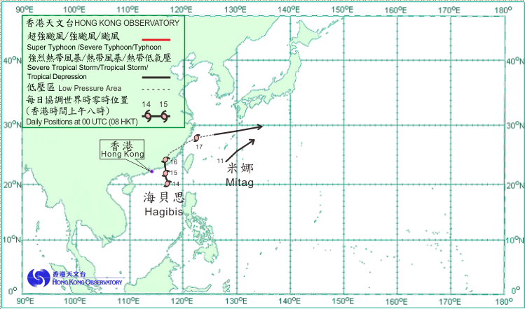
Two tropical cyclones occurred over the western North Pacific and the South China Sea in June 2014. Amongst them, Hagibis necessitated the issuance of the first tropical cyclone warning signal by the Hong Kong Observatory in 2014.
Tropical depression Mitag formed over the western North Pacific about 250 km south of Okinawa on the afternoon of 11 June and moved northeastwards. The estimated maximum sustained winds near its centre was about 55 km/h. Mitag became an extratropical cyclone over the seas east of Okinawa on the morning of 12 June.
Hagibis formed as a tropical depression over the northeastern part of the South China Sea about 380 km southeast of Hong Kong on the morning of 14 June. Drifting north-northwestwards, it intensified into a tropical storm that afternoon and reached its peak intensity that night with an estimated sustained wind of 75 km/h near its centre. Hagibis started to move steadily northwards in the small hours on 15 June as it edged towards the coastal areas of eastern Guangdong. It made landfall near Shantou that afternoon and weakened into a tropical depression during the night. Hagibis weakened further over the inland areas of eastern Guangdong on the morning of 16 June. However, its remnant low pressure area continued to track across the southeastern part of China before entering the East China Sea the next day and re-intensifying into a tropical depression in the afternoon. Moving east-northeastwards, Hagibis finally evolved into an extratropical cyclone over the seas south of Japan on the morning of 18 June. Heavy rain associated with Hagibis led to severe flooding in parts of Guangdong and Fujian where land and sea traffic was disrupted. More than 11 520 hectares of farmland were affected, with economic losses reaching 570 million RMB.
 |
|---|
Tropical cyclone tracks in June 2014