Overview of Tropical Cyclones in November 2013
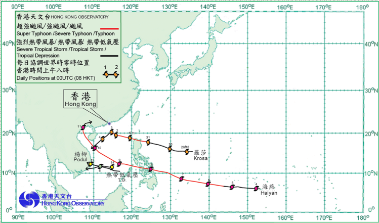
(Tracks)
Four tropical cyclones occurred over the western North Pacific and the South China Sea in November 2013. Amongst them, Krosa necessitated the issuance of tropical cyclone warning signals by the Hong Kong Observatory during the month. Super Typhoon Haiyan was the most intense tropical cyclone in the region so far this year and it brought heavy casualties and damage to the central Philippines.
Krosa formed as a tropical depression over the western North Pacific about 1 580 km east of Manila on 29 October. Moving generally west to west-northwestwards, it intensified gradually into a severe tropical storm the following day. Krosa intensified further into a typhoon on 31 October and crossed the northern tip of Luzon. Krosa entered the northern part of the South China Sea on 1 November. It became slow moving and intensified into a severe typhoon over the northern part of the South China Sea on 2 November, reaching its peak intensity with estimated sustained winds of 165 km/h near its centre. Krosa turned southwestwards on 3 November and weakened gradually into a tropical storm, dissipating over the central part of the South China Sea during the following night. According to press reports, three people were killed, two people were missing and more than 17 000 houses were damaged in the Philippines during the passage of Krosa.
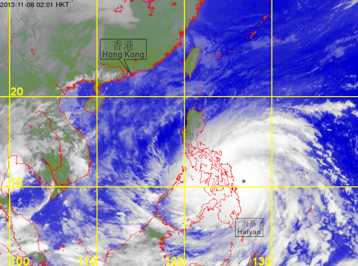
Haiyan formed as a tropical depression over the western North Pacific about 1 240 km southeast of Guam on 4 November and moved west-northwestwards. Haiyan intensified gradually and became a typhoon about 780 km south-southwest of Guam the following day. It strengthened further into a super typhoon on 6 November, reaching its peak intensity with estimated sustained winds of 275 km/h near its centre on 8 November, with its eye clearly discernible on satellite images. Haiyan moved across the central Philippines and entered the South China Sea on 9 November. Turning northwestwards, it passed to the southwest of Xisha and weakened into a severe typhoon at night. It moved across Beibu Wan the following day and weakened into a typhoon. Haiyan made landfall over the coast of northern Vietnam on 11 November, weakened rapidly into a tropical depression and turned east-northeastwards. It dissipated over Guangxi the following day.
According to press reports, Haiyan caused widespread flooding in the central Philippines and brought hugh waves to coastal regions, resulting in landslides, collapsed houses, uprooted trees, power failure and disruption in sea and air traffic. Over 6 000 people were killed, around 1 800 people were reported missing, 28 000 people were injured and the direct economic loss exceeded 10.3 billion Pesos (around HK$1.9 billion) in the Philippines. In Hainan Island, Guangxi and Guangdong, seven people were killed, four people were reported missing, over 9 400 houses collapsed or were damaged, and over 2.95 million hectares of farmland were damaged, with direct economic loss exceeding 4.4 billion RMB. In addition, at least 13 people were killed and 81 others were injured in Vietnam during the passage of Haiyan. Although Hong Kong was not directly in its path, one person was reported missing at Cheung Sha in Lantau Island and later confirmed dead after swimming in turbulent waves and swells whipped up by the high winds under the combined influence of Haiyan and the northeast monsoon.
A tropical depression formed over the southern part of the South China Sea about 320 km east of Nansha on 5 November and moved west to west-northwestwards. The estimated maximum sustained winds near its centre was about 55 km/h. The tropical depression made landfall over the coast of southern Vietnam the following day and dissipated inland.
Podul formed as a tropical depression over the southern part of the South China Sea about 130 km northeast of Nansha on 14 November and moved west to west-northwestwards. The estimated maximum sustained winds near its centre was about 55 km/h. Podul dissipated inland after making landfall over the coast of southern Vietnam the following day. Podul brought heavy rain and severe flooding to the central part of Vietnam, where at least 34 people were killed and 11 others were reported missing.
 |
|---|
Infra-red satellite imagery at 2 a.m. on 8 November 2013, as Haiyan, the most intense tropical cyclone so far this year, reached super typhoon intensity with estimated maximum sustained winds of 275 kilometres per hour near its centre.
[The satellite imagery was originally captured by Multi-functional Transport Satellite-2 (MTSAT-2) of Japan Meteorological Agency (JMA).]
 |
|---|
Tropical cyclone tracks in November 2013