Risk Assessment of South China Sea Tsunami Sources with Potential Impact on Hong Kong
Risk Assessment of South China Sea Tsunami Sources with Potential Impact on Hong Kong
Queenie CC Lam, Wilson WS Chan
The Intergovernmental Oceanographic Commission (IOC) of UNSECO has launched the "Ocean Decade" and has been promoting its Tsunami Ready Recognition Programme in recent years. This program aims to assist countries in developing strategies to address tsunami threats. The community-based programme enhances the awareness of individual and community on tsunami risk and promotes response actions through a variety of measures, thereby reducing the impact of hazards [1]. To achieve the level of "Tsunami Ready", the IOC has set 12 work indicators, the first of which is to have designated and mapped tsunami hazard zones.
According to past records (as of December 2025), Hong Kong has experienced 10 very minor water level anomalies caused by tsunamis, and most of which originated from the Pacific Ocean. The Circum-Pacific seismic belt (also known as the "Ring of Fire") in the Pacific region, covering the Solomon Islands, the Philippines, Japan, North America and etc., experiences frequent seismic activity over the tectonic plate boundaries and has the potential for megathrusts1 in subduction zones2. It is the region with the highest frequency of occurrence of tsunami in the world. If a tsunami occurs in the Pacific, the tsunami waves propagating from the Pacific to Hong Kong will weaken due to diffraction3 around islands. Typically, only a small fraction of energy will enter the South China Sea. As a result, tsunamis triggered by major earthquakes in the Pacific basically pose no severe threat to Hong Kong. As for the South China Sea, there is also a potential risk of earthquake-induced tsunamis. Figure 1 shows a schematic diagram of potential tsunami sources in the South China Sea region. Historically, earthquakes of magnitude 7 or above in the South China Sea have occurred at the eastern end of the Littoral Fault Zone (such as the 1918 magnitude 7.3 Nan'ao earthquake near Shantou) and its western end (such as the 1605 magnitude 7.5 Qiongzhou earthquake), as well as near the Manila Trench. Should a major earthquake occur along the Manila Trench, the Littoral Fault Zone, or the Continental Slope Fault Zone, though the probability is very low, Hong Kong could be impacted by tsunami waves coming directly from these sources. It is therefore essential to assess the potential risk and impact of the tsunami sources in the South China Sea on Hong Kong. In addition to submarine earthquakes, submarine landslides or volcanic eruptions can also trigger tsunamis. At present, predicting non-seismic tsunamis is a major challenge for tsunami warning centers around the globe, and active research on related scientific issues is still needed.
Figure 1. Schematic diagram of potential tsunami sources in the South China Sea region, and the epicenters of earthquakes felt in Hong Kong (including incomplete records of earthquakes that were likely to have been felt in Hong Kong before 1979 [2,3] and earthquakes felt in Hong Kong since the setup of the short-period seismograph monitoring network in 1979 till December 2025 [4]).
Manila Trench
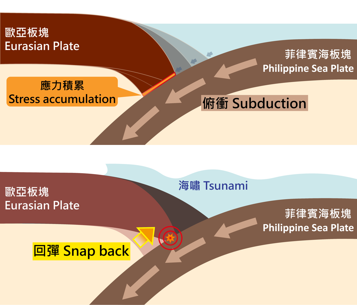
The Manila Trench is located at the waters west of Luzon of the Philippines. Formed by the convergence between the Eurasian Plate and the Philippine Sea Plate, this trench is a subduction zone (Figure 2). Geodetic measurements indicate that near the Luzon Strait area, the Philippine Sea Plate moves towards the Eurasian Plate at a rate of 5 to 10 cm per year [5,6]. Over the past century, the strongest recorded earthquake along the Manila Trench was the M7.6 event in 1934, during which minor tremors were felt in Hong Kong. While there were reports that tsunami was observed south of Luzon Island, there was no record of having such tsunami affected Hong Kong. The Manila Trench has frequent light to moderate magnitude earthquakes, but strong earthquakes are not active [7]. This pattern suggests two possibilities: either the fault releases energy gradually through smaller earthquakes or aseismic creep; or stress is accumulating until it exceeds the limit of friction between the plates and releases energy in the form of a major earthquake in the future [5]. Some studies have also pointed out that based on geological structure analyses, the Manila Trench has the potential risk of having an earthquake of M8.5 or above. There is no consensus on the estimation of return period, and it is generally believed to be hundreds of years, or even 1,000 years or more [6,8]. There is also no consensus on the theoretical maximum probable magnitude. In fact, there has never been a recorded earthquake of magnitude 8 or above in that area. At present, the scientific community has not yet reached a consensus on the two possibilities mentioned above. From the risk assessment perspective, we need to make an assessment based on a worse case scenario.
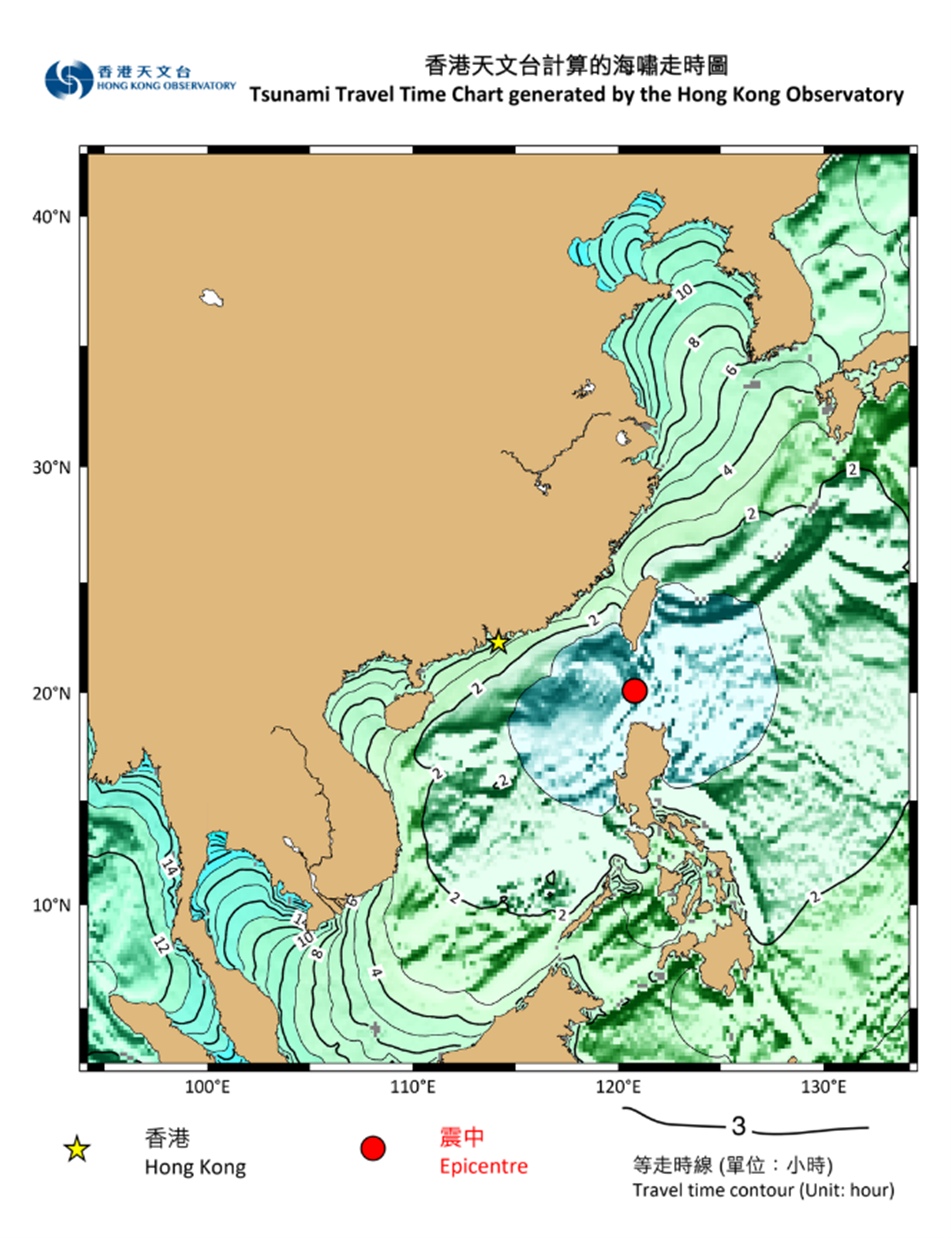
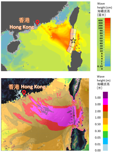
Generally speaking, shallow undersea earthquakes of magnitude 7 or above may trigger tsunamis, though this does not necessarily mean that lower magnitude earthquakes will not. If an earthquake along the Manila Trench triggers a tsunami, the first tsunami wave will reach the southeastern coast of China, including Hong Kong, normally in some 3 hours after the earthquake (Figure 3). The wave height depends on a variety of factors. The related parameters are earthquake magnitude, epicenter location, focal depth, the extent of fault rupture, and its geometric parameters including displacement, fault strike, dip, and slip direction (i.e. focal mechanism). If the epicenter is near the northern segment of the Manila Trench (i.e. northern Luzon), the energy transmission of the tsunami waves will be more concentrated along the southeastern coast of China. If a very low probability of occurrence of a shallow great earthquake with magnitude 8 occurs in the Manila Trench, it will generate a significant tsunami spreading across the South China Sea and affect distant coastal areas [8-11]. The Observatory will then assess the need for issuance of the Tsunami Warning. Figure 4 shows the tsunami model simulation results of a hypothetical shallow earthquake of magnitude 8.6 along the Manila Trench. The Observatory's tsunami model outputs indicated that Hong Kong might experience a tsunami with height of about 1 to 2 m at the coast, and possibly 3 m in some localised places. The results for Hong Kong offshore are generally consistent with those from the Tsunami Coastal Assessment Tool (TsuCAT) [12] of the Centre for Tsunami Research of the U.S. National Oceanic and Atmospheric Administration (NOAA).
Figure 2. The Philippine Sea Plate subducts beneath the Eurasian Plate, accumulating stress between the two plates (top); the Eurasian Plate rebounds to release the accumulated stress, generating an earthquake and a tsunami (bottom).
Figure 3. Tsunami travel time (TTT) based on the calculations by the Hong Kong Observatory for tsunami waves to reach near shore in case when an earthquake occurs in the northern end of the Manila Trench.
Figure 4. Tsunami wave height predictions for a hypothetical M8.6 shallow great earthquake along the Manila Trench generated by the U.S. TsuCAT program (top); and the Hong Kong Observatory’s tsunami model (bottom).
Littoral Fault Zone and Continental Slope Fault Zone
Hong Kong lies within the Eurasian Plate. The geological environment is characterised primarily by intraplate deformation, and the fault structures are smaller than those in the subduction zone. According to seismic hazard studies by the Geotechnical Engineering Office (GEO) of the Civil Engineering and Development Department (CEDD), the seismicity of Hong Kong is classified as low to moderate, with no clear evidence of significant recent fault activities in Hong Kong, either onshore or offshore [13]. The probability of occurrence of a major earthquake is very low.
The Littoral Fault Zone is situated in the coastal waters of the northern part of the South China Sea (Figure 1), an intraplate fault zone within the Eurasian Plate rather than a plate boundary. It stretches over 1,200 km from the Beibu Wan in the west to Fujian in the east. It is characterised as a normal4 strike-slip fault5 with relatively low crustal activity, very low strain rates and extremely slow stress accumulation. The recurrence intervals of major earthquakes are believed to be exceptionally long, and the frequency and probability of occurrence of large earthquakes are low. According to the historical records spanning over 400 years (as of December 2025), there were four earthquakes with magnitude 7 or above, all located at the eastern end or western end of the Littoral Fault Zone, including the M7.0 Nan’ao major earthquake in 1600, the M7.3 Nan’ao major earthquake in 1918, the M8.0 Quanzhou great earthquake in 1604, and the M7.5 Qiongzhou major earthquake in 1605, as well as around 30 earthquakes with magnitude 6 or above [2,3,4,13]. Among them, the M7.3 Nan'ao earthquake on 13 February 1918 was the strongest earthquake felt in Hong Kong in over a century. Even though the epicenter was more than 300 km away, the earthquake intensity reached VI (6)6 to VII (7)7 on the Modified Mercalli Intensity (MMI) scale in Hong Kong.
Some recent studies pointed out that the Dangan Islands Fault (part of the Littoral Fault Zone) located approximately some 30 to 50 km south of Hong Kong experiences a seismic gap (i.e. no strong earthquake on record) of the Littoral Fault Zone [14]. However, it has the potential of having a strong earthquake. According to seismic hazard studies by the GEO/CEDD, the upper limit of earthquake magnitude in the area is about 7.0 - 7.5 [15,16,17,18]. It is worth noting that this is only a theoretical worst-case scenario with a return period of probably thousands of years, and the chance of occurrence is extremely low. If an earthquake triggers a tsunami there, the tsunami waves can reach south of Hong Kong waters within an hour. The Observatory has used a tsunami model to simulate the extremely low probability worst-case scenario, which may bring a tsunami wave of around 1 m high to the coast of Hong Kong, and possibly 2 m in some localised places. The sea current speed over Hong Kong waters will also significantly increase and may reach as high as around 1 m/s, several times or more higher than that under normal situations. This is similar to the estimates in literature [19,20]. However, some researchers pointed out that the exceptionally slow slip rate of the fault requires immensely long periods for a strong earthquake to occur, and it may probably generate a tsunami only in local regions [14].
The Continental Slope Fault Zone is a northeast-oriented normal strike-slip fault zone near the edge of the continental shelf (Figure 1). Recent mainland studies suggested that the Continental Slope Fault Zone has the potential of producing earthquakes with magnitude of around 7 based on geological consideration [21]. However, currently there is not much relevant literature and further research is needed.
Submarine Landslides
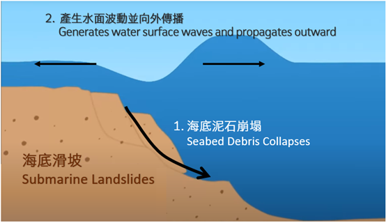
Tsunamis generated by submarine landslides involve highly complex mechanisms (Figure 5). The resulting tsunami amplitude depends on multiple factors, making risk assessment exceptionally challenging. Some researchers pointed out in the case of M5.7 Luzon earthquake in June 1988, although the magnitude was not large, it still generated a tsunami that was also recorded in Hong Kong. Some researchers indicated that the cause of which might be that the earthquake had triggered a submarine landslide [11]. Some also pointed out that several submarine structures in the South China Sea have the preconditions for occurrence of submarine landslides. They named these submarine structures as Qiongbei, Huaguang, and Baiyun Landslides (Figure 1), and studied the destructive power of the associated potential tsunamis in different scenarios. Among them, the Baiyun landslide can bring significant tsunamis to the South China coast in the worst-case scenario [22]. Overall speaking, the risk assessment of tsunamis caused by submarine landslides in the South China Sea remains at an early stage [14]. The specific mechanisms, preconditions, and probabilities still require substantial further research.
Figure 5. Mechanism for tsunami generation by submarine landslides.
Concluding Remarks
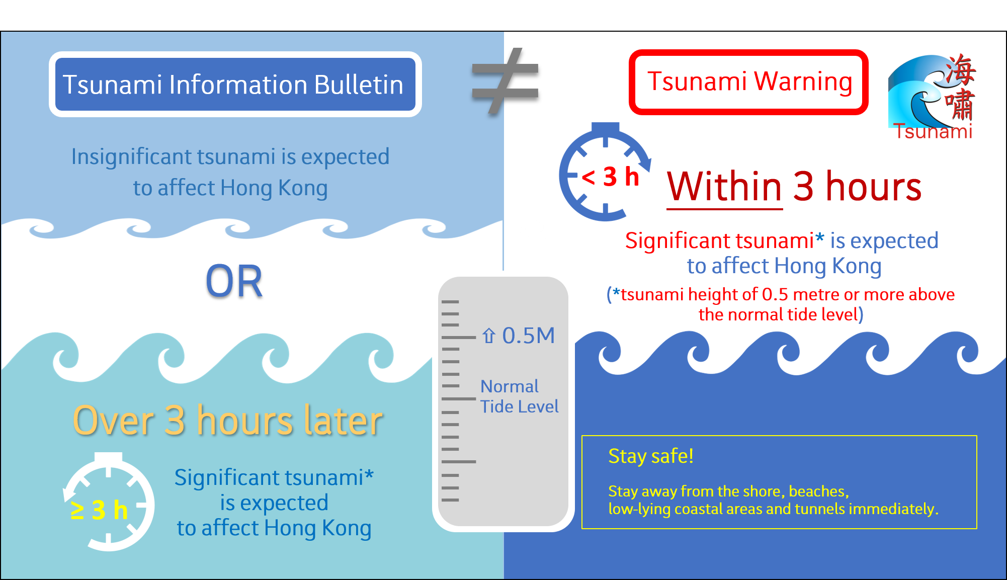
Hong Kong’s geographical location is sheltered from islands like Luzon and Taiwan which weaken the tsunamis from the Pacific reaching Hong Kong. Since the introduction of the Tsunami Warning in 1960s, Hong Kong has not been affected by any significant tsunami which necessitates the issuance of warning. Very minor tsunamis had small amplitudes and the water level anomalies were below 0.5 m. They were basically within the range of local astronomical tide variation and posed minimal impact to the coastal region. In the past (as of December 2025), Hong Kong has recorded 10 cases of very minor water level anomalies caused by tsunamis. Two cases of which recorded the highest tsunami amplitude of about 0.3 m, and were generated by the M9.5 Chile great earthquake in 1960 and the M5.7 Luzon Strait earthquake in 1988. If a significant tsunami (i.e. 0.5 m or more above the normal tide level) is expected to reach Hong Kong within 3 hours, the Observatory will issue the Tsunami Warning to remind members of the public to take precautions, and urge them to stay away from the shore, beaches, low-lying coastal areas and tunnels. If the tsunami is not expected to be significant, or if it is expected to reach Hong Kong more than 3 hours, the Observatory will issue the Tsunami Information Bulletin to inform members of the public (Figure 6). Regarding tsunamis in the South China Sea region, while there are several potential sources, the probability of occurrence of tsunami is relatively low. The public should not be overly worried. However, awareness of earthquakes and tsunamis as well as disaster prevention should be heightened and the way to cope with hazards should be understood. For details, please refer to the Observatory’s blog titled "Earthquake and Tsunami Knowledge We Need to Know". In the event of encountering an earthquake-induced tsunami or its precursors, keep calm and stay away from the shoreline, beaches and low-lying coastal areas. If you are in these places, move to inland or higher grounds, or stay safe on the upper floors of high multi-storey buildings, and follow official guidelines. Tsunamis can come repeatedly, and therefore one should stay away from the shoreline before the cancellation of Tsunami Warning.
Figure 6. Schematic diagram illustrating the differences between Tsunami Information Bulletin and Tsunami Warning.
1 A megathrust earthquake is a great earthquake that occurs in subduction zones, where the reverse fault forms when the rocks on the "uphill" side of an inclined fault plane rise above the rocks on the other side.
2 A subduction zone occurs at convergent plate boundaries where the denser oceanic plate is forced underneath another plate when two tectonic plates collide and squeeze together.
3 Diffraction is a physical phenomenon that when propagating waves encounter an obstacle, they bend around the edge of the obstacle and deviate from their original straight path.
4 A normal fault is a type of dip-slip fault in geological structure where the block above the fault moves downward relative to the block below.
5 A fault on which the two blocks slide past one another.
6 Earthquakes with intensity VI would be felt by all. Many frightened and run outdoors. Persons walk unsteadily. Windows, dishes, glassware broken.
7 Earthquakes with intensity VII would be difficult for people to stand. Noticed by drivers of motor cars. Hanging objects quiver. Furniture broken. Damage, including cracks, to masonry with weak materials or low standards of workmanship.
Acknowledgment:
Thanks to the experts from the Tsunami Group of the National Marine Environmental Forecast Center of the Ministry of Natural Resources of China for their comments on this article.
![Figure 1. Schematic diagram of potential tsunami sources in the South China Sea region, and the epicenters of earthquakes felt in Hong Kong (including incomplete records of earthquakes that were likely to have been felt in Hong Kong before 1979 [2,3] and earthquakes felt in Hong Kong since the setup of the short-period seismograph monitoring network in 1979 till December 2025 [4]).](../../../en/gts/equake/images/Littoral Fault Zone with Earthquake Felt in Hong Kong since 1900_en.png)