Squall and Lightning Associated with Severe Convective Weather
Squall and Lightning Associated with Severe Convective Weather
Leung Ka-fai
December 2025
Severe convective weather occur frequently in spring and summer. Under suitable weather conditions such as cold front, trough of low pressure or being influenced by high temperatures, the atmosphere becomes unstable. Together with abundant moisture supply brought by warm and humid maritime airstream, the warm moist air near the ground surface rises violently, generating powerful updrafts and resulting in the development of cumulonimbus clouds of 10 kilometers or more in height [1]. At the same time, thunderstorms associated with severe convective weather often bring hazardous weather phenomena such as lightning and squall, etc.; so how do lightning and squall occur?
When the atmosphere is unstable, updrafts carry water vapor aloft where it cools and condenses into water droplets, ice crystals, or even ice pellets. The strong updrafts make the ice crystals and ice pellets to collide and rub against each other violently, leading to the separation and accumulation of electrical charges. When the accumulated electrical charge creates a sufficiently large electrical potential difference between clouds or between clouds and the ground, the discharge phenomenon occurs which is commonly observed as lightning.
In a cumulonimbus cloud, when water droplets or ice particles grow large enough that the updraft can no longer keep them aloft, they begin to fall rapidly. Owing to friction, the descending rain drops and ice particles will drag the surrounding air to subside as well. Meanwhile, these falling rain drops or ice particles evaporate or melt upon encountering warmer air in the lower atmosphere. The energy required for that phase change is absorbed from the surrounding air, causing it to cool rapidly. Since the cooler air is denser, the rain droplets and ice particles cause the surrounding air to accelerate downward further, forming a “downburst”. When this strong downdraft reaches the ground, it spreads outward and results in sudden outburst of gusts at the front of the thunderstorm. Wind speed will soar rapidly in a short period of time, producing squall[2] we feel.
A notable characteristics of severe convective weather is its extremely rapid development that can bring frequent cloud-to-ground lightning and extremely destructive winds in a short period of time. Taking a case of severe squally thunderstorm during the evening on 25 July 2025 as an example. Severe thunderstorms triggered by high temperatures continued to develop rapidly to the north of Hong Kong in the afternoon and began to affect the territory since 6 p.m. (Figure 1). More than 2,900 cloud-to-ground lightning strikes were recorded in the territory within the following couple of hours. In particular, violent gusts of around 110 kilometres per hour, which are equivalent to storm force winds, were also recorded at Sai Kung at around 6:50 p.m., a sharp increase from only around 10 kilometres per hour just half an hour earlier (Figure 2). Such rapid development of severe convection, together with the intense lightning and squalls, poses serious threats to people engaging in outdoor operations and activities, especially those at heights or on open waters.
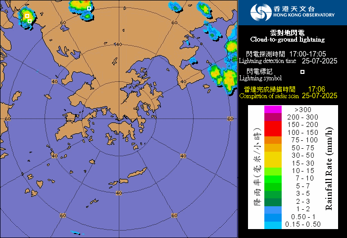
Figure 1 Radar imagery overlaid with cloud-to-ground lightning on 25th July 2025. Heat-triggered thunderstorms developed rapidly over eastern Hong Kong waters, accompanied by intense lightning.
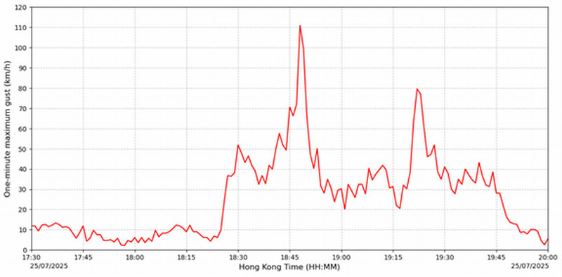
Figure 2 Time series of one-minute maximum gust recorded at Sai Kung Automatic Weather Station from 5:30 p.m. to 8:00 p.m. on 25 July 2025.
Given the explosive development and hazardous nature of severe convective weather, the Hong Kong Observatory (HKO) issues the Thunderstorm Warning when thunderstorms may affect the territory within a short period of time, notifing the public to take precautionary measures. Apart from using radar and satellite imagery as well as real-time lightning location data to monitor and forecast the development of thunderstorms, forecasters also make reference to severe weather forecast products from the HKO’s in-house developed “SWIRLS” (Short-range Warning of Intense Rainstorms in Localized Systems) nowcasting system.
SWIRLS utilizes the latest radar and lightning location data to calculate the direction and speed of thunderstorm movement and generate lightning nowcast products. Location-based lightning nowcast and movement of thunderstorm for the next one hour can be accessed through the "Automatic Regional Weather Forecast in Hong Kong and Pearl River Delta Region" webpage (Figure 3) or the "Location-based Rainfall and Lightning Forecast" on the "MyObservatory" app. Furthermore, SWIRLS employs the conceptual model of the mechanisms of downburst formation mentioned above, combining radar and upper-air weather observations to estimate the intensity of wind gusts potentially brought by the thunderstorms. The Observatory will also mention "severe squally thunderstorms" and related high-impact weather information in the Thunderstorm Warning as appropriate, to remind members of the public to take appropriate precautionary actions.
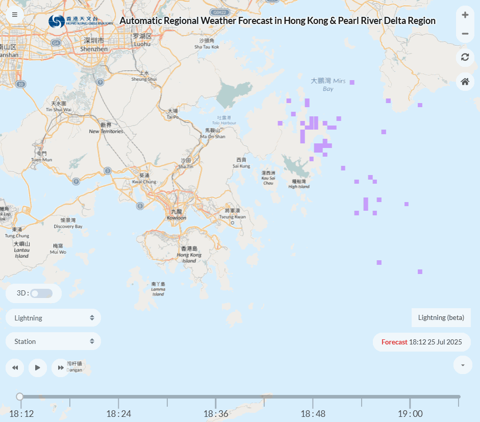
Figure 3 1-hour lightning nowcast on the "Automatic Regional Weather Forecast in Hong Kong and Pearl River Delta Region" webpage.
Since severe convective weather can develop rapidly, the public should regularly take note of the latest weather information through the HKO’s website or the "MyObservatory" app when planning and carrying out outdoor activities. When the Observatory issues a thunderstorm warning, seek shelters indoor as soon as possible for safety reasons.