Why is it Sunny in the Morning but Thundering and Raining in the Afternoon?
Why is it Sunny in the Morning but Thundering and Raining in the Afternoon?
CHAN Yun-san
December 2023
It may be a common experience for us that a sunny and clear morning in the summer may turn into a gloomy afternoon with showers and squally thunderstorms. What causes such an abrupt change in weather?
Convective Precipitation
On a sunny day, abundant sunshine causes the ground surface temperature to rise. This heats up the air near the ground which leads to the development of thermal convections. The thermal convection becomes more active as the ground temperature rises further. If the atmosphere is unstable, the relatively warm and moist air near ground surface can easily rise to upper atmosphere and cumulonimbus clouds will be formed. In the presence of other favourable conditions, such as abundant moisture supply, upper air divergence, etc., the active thermal convections may even lead to severe convective weather like thunderstorms or intense gusts. This type of showers and thunderstorms triggered by high temperatures usually occurs in the afternoon and can develop rapidly, causing the weather to deteriorate within a short period of time. Nonetheless, the showers will bring cooler air in the upper atmosphere to the ground. With lower ground surface temperature, thermal convection will be reduced and cumulonimbus clouds will eventually dissipate. The sky will then become clear again.
For example, on 30th August 2022, there were sunny periods locally, and temperatures over many places rose to about 33 degrees. However, thundery showers triggered by high temperatures developed over Hong Kong after midday (Figure 1) and brought more than 10 millimetres of rainfall to Kowloon and parts of the New Territories. The abrupt change from sunshine to showers could be seen from the weather photos taken at Victoria Harbour (Figure 2).
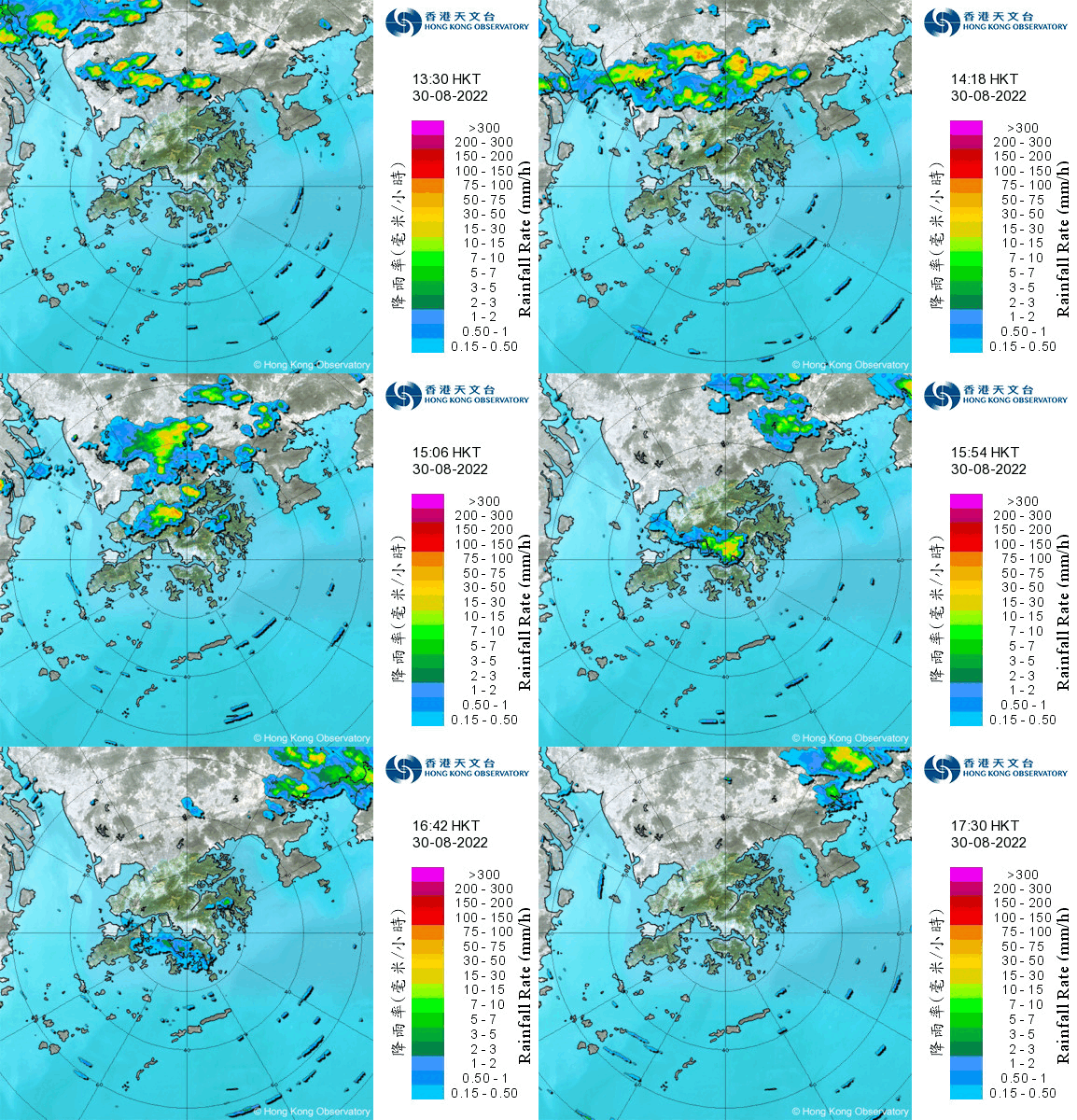
Figure 1 Radar images on 30th August 2022. Thermal convections developed over Hong Kong in the afternoon.
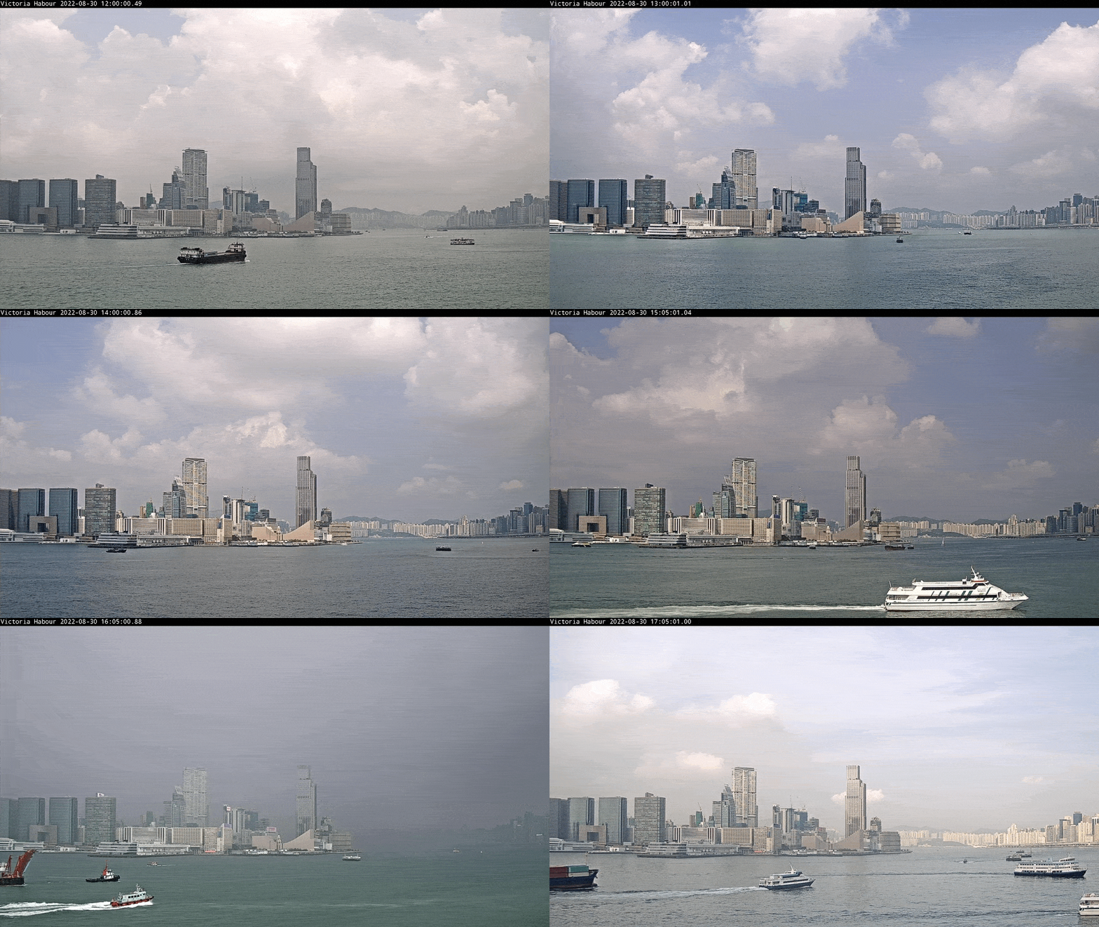
Figure 2 Weather photos of Victoria Harbour taken at Central in the afternoon of 30th August 2022.
Thundery showers brought by tropical cyclones far away
Tropical cyclones at a distance from Hong Kong can also bring sudden thundery showers to the territory. When a tropical cyclone is located over northeastern part of the South China Sea or in the vicinity of Luzon and Taiwan, Hong Kong will be affected by its subsiding air. The local weather will usually be fine and very hot. Initially, thermal convections triggered by high temperatures will be suppressed by the subsiding air. Yet, they will become more active as the ground temperatures continues to rise, and will ultimately overcome the suppression, rising to upper atmosphere which leads to the formation of thunderstorms. Besides, if the outer circulation of the tropical cyclone brings north or northeasterly winds at the upper-air over the southeastern part of China, thunderstorms triggered by high temperatures over inland may move towards the coast along the winds and affect Hong Kong in the late afternoon or even after dusk. Therefore, this kind of thunderstorms are sometimes called “evening thunderstorms”.
As an example, during the day of 15th July 2023, under the influence of the outer subsiding air of Tropical Cyclone Talim, the weather over the coast of Guangdong was fine and very hot. Advected from the circulation of Talim, thunderstorms triggered by high temperatures inland edged from the northeast and reached Hong Kong around the evening (Figure 3).
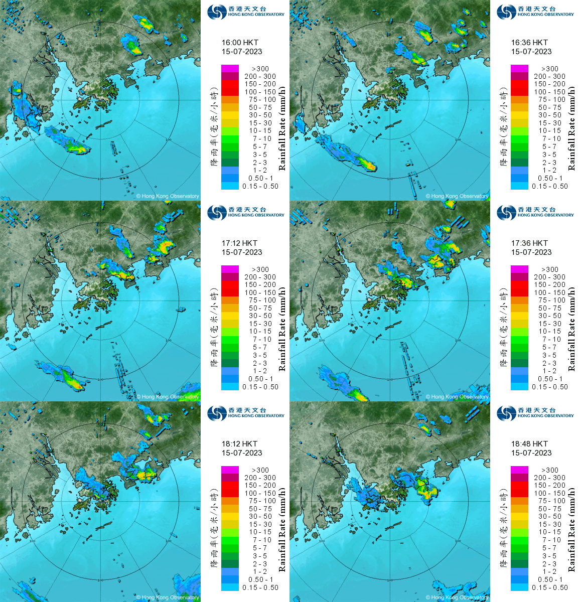
Figure 3 Radar images on 15th July 2023. Thunderstorms triggered by high temperatures over inland area moved to Hong Kong along the northeasterlies.
Afternoon thundery showers in the autumn
Even in autumn, thunderstorms may occur in the afternoon, and these are often caused by sea breeze convergence. In early autumn, the northeast monsoon normally starts to affect southern China, but it is usually quite weak. The ground temperatures will still be relatively high on sunny days. Sea breeze may thus set in and converge with the background northeast monsoon over the coastal areas. This can even trigger convective weather if the atmosphere is unstable. On 3rd September 2020, a weak northeast monsoon affected Guangdong. With the surface air temperatures rising, southerly sea breeze set in over the Hong Kong Island and Kowloon around noon, while the New Territories was still under the influence of northerly winds (Figure 4). After midday, showers and squally thunderstorms developed over the convergence zone in the vicinity of southern part of the New Territories and the northern part of Kowloon (Figure 5), which brought more than 70 millimetres rainfall to Sha Tin. More than 2000 strokes of cloud-to-ground lightning were recorded within the territory.
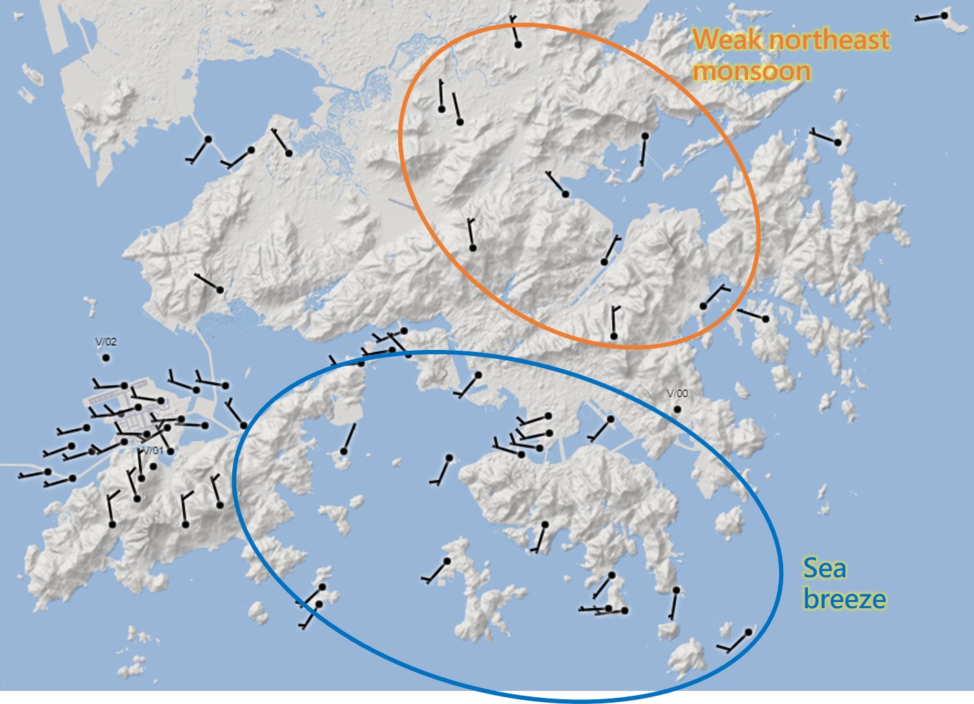
Figure 4 At 11 a.m. of 3rd September 2020, southerly sea breeze set in at Hong Kong island and Kowloon, but the New Territories was still under the influence of the weak background northeast monsoon.
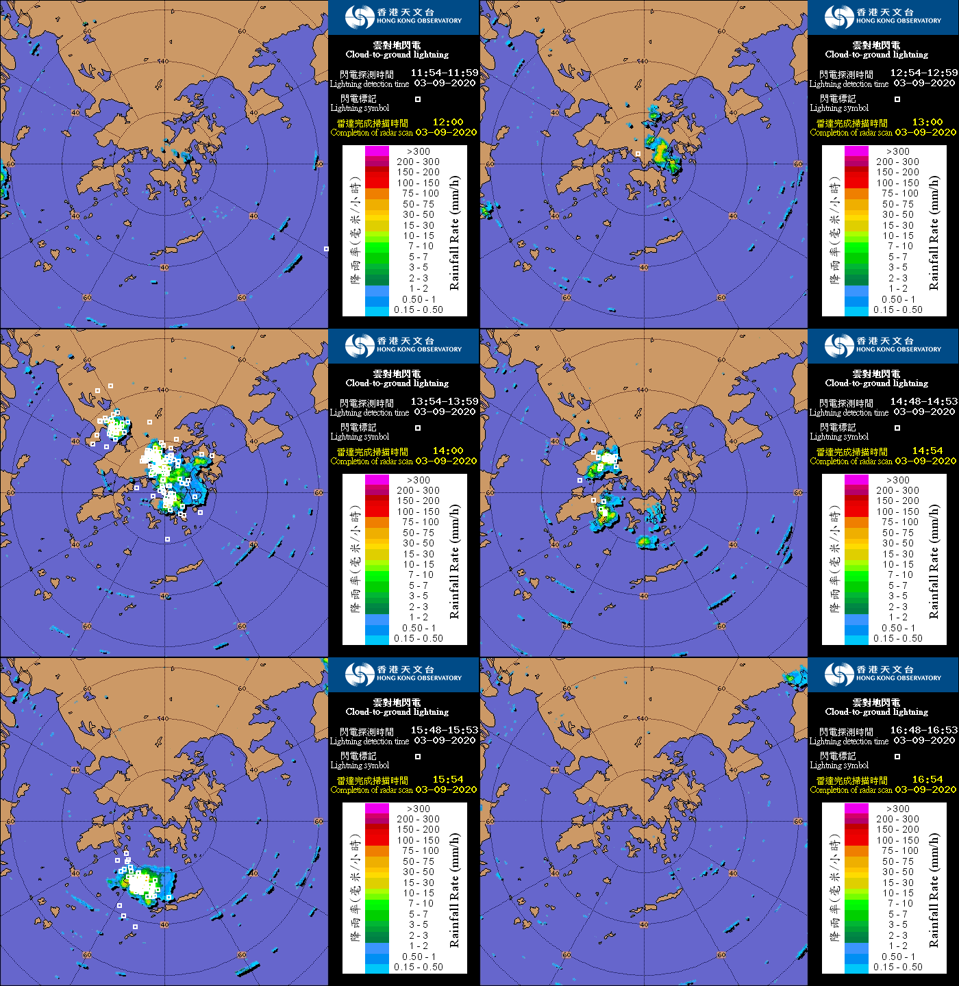
Figure 5 Radar images on 3rd September 2020 overlaid with cloud-to-ground lightning. Showers developed over the southern part of the New Territories as well as the northern part of Kowloon in the afternoon and gradually moved southward, along with active thunderstorm development.
During summer and autumn, even on days with fine weather, forecasters of the Observatory will carefully evaluate the chance of showers and thunderstorms by analyzing the weather situation as well as using various forecasting tools, and will issue forecasts and warnings to the public in a timely manner. Nevertheless, the actual time and location of occurrence of thundery showers are random in nature and remain major challenges in weather forecasting. Hence, please still exercise care and pay attention to the latest weather information issued by the Observatory even if it is sunny in the morning. When taking part in outdoor activities, check whether the Thunderstorm Warning is in force and its affected regions.