Very Hot Weather and Storm Surges Triggered by Tropical Cyclones
Very Hot Weather and Storm Surges Triggered by Tropical Cyclones
LAI Sin-ki
April 2021
The Hong Kong Observatory (HKO) has conducted meteorological monitoring for over 130 years starting with the measurement of basic meteorological elements like air pressure, temperature, humidity, wind speed and direction, rainfall etc., and then followed by making upper air and tidal measurements etc. Continuous and regular acquisitions of meteorological data are essential for establishing a climatological database for Hong Kong. Such database enables us to obtain the climatological average values of different meteorological elements with respect to various seasons and provides the foundation for weather forecasting and climate change monitoring. In this article, we have extracted some tropical-cyclone-related records in recent years from the database, and will briefly discuss the causes of these records.
Up to 2020, the top two maximum temperatures recorded at the HKO Headquarters were 36.6°C on 22 August 2017 and 36.3°C on 8 August 2015 (Table 1) since records began in 1884. Both of these records were associated with the subsiding air at the outer circulation of tropical cyclones (Hato in 2017 and Soudelor in 2015).
| Ranking | Maximum temperature (°C) | Date |
|---|---|---|
| 1 | 36.6 | 22 August 2017 |
| 2 | 36.3 | 8 August 2015 |
| 3 | 36.1 | 19 August 1900 |
| 4 | 36.1 | 18 August 1900 |
| 5 | 35.7 | 25 July 1968 |
Table 1 Top 5 rankings of maximum temperatures recorded at HKO Headquarters during 1884-2020 (excluding 1940-1946).
Occasionally, the weather in Hong Kong could be very hot together with intense sunshine and light wind conditions when a tropical cyclone is in the vicinity of Taiwan or Luzon strait. This is caused by the subsiding air at the outer circulation of the tropical cyclone. When the intense rising air near the centre of a tropical cyclone reaches the top of the troposphere, it can no longer rise but spread sideway due to the generally stable atmosphere aloft (stratosphere). It will eventually subside at the outer edge of the tropical cyclone (Figure 1). The subsiding air will raise the air temperature and suppress the formation of clouds. As a result, the weather in the affected regions is often sunny, hot and stuffy with haze.
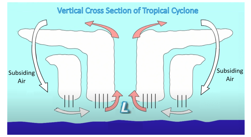
Figure 1 Subsiding air at the outer edge of the tropical cyclone.
The weather normally deteriorates with squalls and heavy rain, and may be even storm surge as the tropical cyclone edges closer to Hong Kong. The low-pressure centre of the tropical cyclone sucks up sea water, while the high winds can push the water towards the shore (Figure 2). The combined effect causes the sea levels near the centre of the tropical cyclone to rise and trigger storm surge.
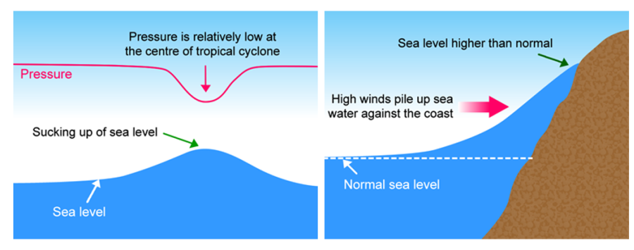
Figure 2 Low pressure centre of a tropical cyclone sucks up sea water (left), the force of high winds pushes water to the shore (right).
Storm surge is calculated by subtracting the astronomical tide (created by gravitational attractions of the Moon and the Sun) from the sea level measured (Figure 3). The maximum storm surge recorded at Quarry Bay/North Point tide gauge was 2.35 m on 16 September 2018 (Table 2) [1], associated with Super Typhoon Mangkhut [2].
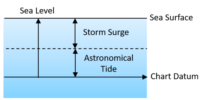
Figure 3 Sea level, storm surge and astronomical tide (not to scale).
| Rank | Storm Surge (metre above astronomical tide) |
Tropical Cyclone | Date |
|---|---|---|---|
| 1 | 2.35 | Mangkhut | 16 September 2018 |
| 2 | 1.77 | Wanda | 1 September 1962 |
| 3 | 1.68 | Ida | 29 August 1954 |
| 4 | 1.49 | Ruby | 5 September 1964 |
| 5 | 1.45 | Hope | 2 August 1979 |
Table 2 Top five rankings of tropical cyclone-induced storm surge measured at Quarry Bay/North Point tide gauge station [1]
The top two highest sea levels recorded at Quarry Bay/North Point were 3.96 m on 1 September 1962 and 3.88 m on 16 September 2018 (Table 3) [3], which were associated with tropical cyclones Wanda and Mangkhut respectively. The day Mangkhut hit Hong Kong fell on the seventh day of the eighth month of the lunar calendar, which was close to a neap tide day. Should Mangkhut have hit Hong Kong during the spring tide, the damages must be even more devastating. The sea level would also be affected by other factors such as the monsoon, shape of the coastlines, etc. Various factors could superimpose to affect the sea levels at different locations to different extents.
| Rank | Sea Level (metre above chart datum) |
Tropical Cyclone | Date |
|---|---|---|---|
| 1 | 3.96 | Wanda | 1 September 1962 |
| 2 | 3.88 | Mangkhut | 16 September 2018 |
| 3 | 3.57 | Hato | 23 August 2017 |
| 4 | 3.53 | Hagupit | 24 September 2008 |
| 5 | 3.38 | Utor | 6 July 2001 |
Table 3 Top five rankings of sea level during tropical cyclones measured at Quarry Bay/North Point tide gauge station [3]
Apart from squalls and heavy rain, very hot weather and storm surges associated with tropical cyclones should not be overlooked. With a warming globe and rising sea level, more frequent occurrences of extreme weather would be expected and the impact of which would even more pronounced. Let us contribute through continuously and actively adopting greener living style, saving energy and reducing carbon emissions.
The 132nd Episode of “Cool Met Stuff”: Outside the Core of a Storm (broadcast in Cantonese)
The 205th Episode of “Cool Met Stuff”: Special Series for Hato - Storm Surge blamed for all the calamity (broadcast in Cantonese)