Heavy or light showers? Isolated showers?!
Heavy or Light Showers? Isolated Showers?!
Lam Ka-fai
December 2025
“It’s pouring over here! Is it not raining where you are?” Many of us may have similar experience. Why can the weather vary so much across different parts of such a small place as Hong Kong, e.g. raining in some areas but sunny in others?
Generally speaking, meteorological conditions conducive to convection include abundant moisture, unstable atmosphere, and dynamic lifting mechanism (Figure 1). When these conditions are met simultaneously at a geographical location, there is potential for convective weather such as showers or thunderstorms to occur over that location. However, depending on weather situations, the spatial distributions of these triggering conditions would be different, causing convections to occur only in localised areas. The following are some examples of weather situations leading to isolated showers in Hong Kong.
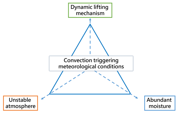
Figure 1 Meteorological conditions conducive to convection include abundant moisture, unstable atmosphere, and dynamic lifting mechanism.
Isolated Showers Triggered by High Temperatures
On 6 August 2024, an anticyclone aloft brought generally fine weather to Hong Kong. However, according to the upper-air weather measurements at 8 a.m. that day, the Convective Available Potential Energy (CAPE) [1] was over 5000 J/kg. Based on past data, the 90th percentile of CAPE from July to September is about 4000 J/kg in Hong Kong. This indicates that the CAPE value on that day was higher than on 90% of the days during the same period, showing that the atmosphere was actually very unstable. Temperatures over the territory generally rose to 33 degrees Celsius or above around noon. It was extremely hot over the northern part of the New Territories, reaching 35 degrees or higher (Figure 2). High temperatures, which favour upward air movement, combined with the unstable atmosphere, eventually triggered isolated heavy showers and thunderstorms. Rainfall was particularly heavy over Tsuen Wan in the afternoon, with over 70 mm recorded. However, only a few millimetres or even no rainfall at all were recorded over other areas like Sha Tin, Sai Kung, and Lantau Island (Figure 3). One can imagine how different the weather would have been experienced by people at different locations that day.
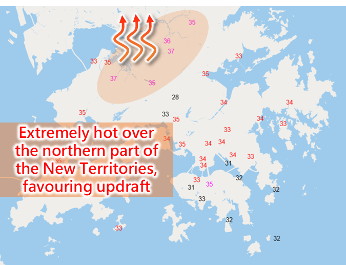
Figure 2 On 6 August 2024, temperatures over the territory generally rose to 33 degrees Celsius or above around noon. It was extremely hot over the northern part of the New Territories, reaching 35 degrees or higher (Figure 2). High temperatures, which favour upward air movement, combined with the unstable atmosphere, eventually triggered localised heavy showers and thunderstorms.
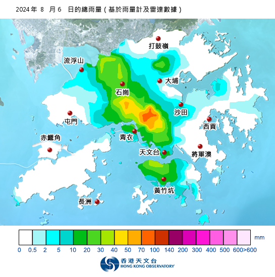
Figure 3 Daily rainfall map of 6 August 2024.
Isolated Showers Caused by Surface Wind Convergence
Contrary to the previous example, even under a relatively stable atmosphere, convections can still occur if the dynamic lifting mechanism (such as surface wind convergence) is sufficiently prominent in a localised area. On 10 October 2024, under the influence of the northeast monsoon, the weather in Hong Kong was relatively stable. The CAPE at 8 p.m. that day was only 50 J/kg. An easterly airstream arrived at the eastern coast of Guangdong during the overnight period from 10 October to the 11 October. It then strengthened progressively and affected Hong Kong. This easterly airstream formed a convergence zone with the background northerlies, forcing air to ascend, and triggering showers over the eastern parts of the territory (Figure 4). Showers were more significant over the region in the morning of 11 October. More than 20 mm of rainfall were recorded (Figure 5). With the convergence zone weakening and departing, the showers gradually dissipated. As seen from the rainfall distribution map, residents in the western parts of the territory might not have experienced this weather event between 10 October and 11 October.
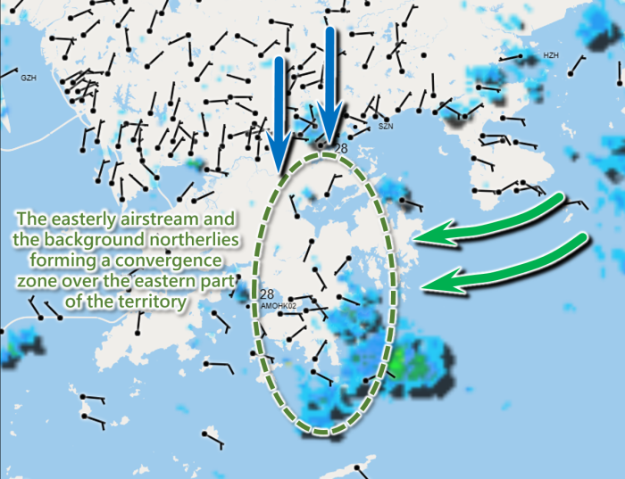
Figure 4 An easterly airstream arrived at the eastern coast of Guangdong during the overnight period from 10 October to 11 October 2024. This easterly airstream formed a convergence zone with the background northerlies, forcing air to rise, and triggering showers over the eastern parts of the territory.
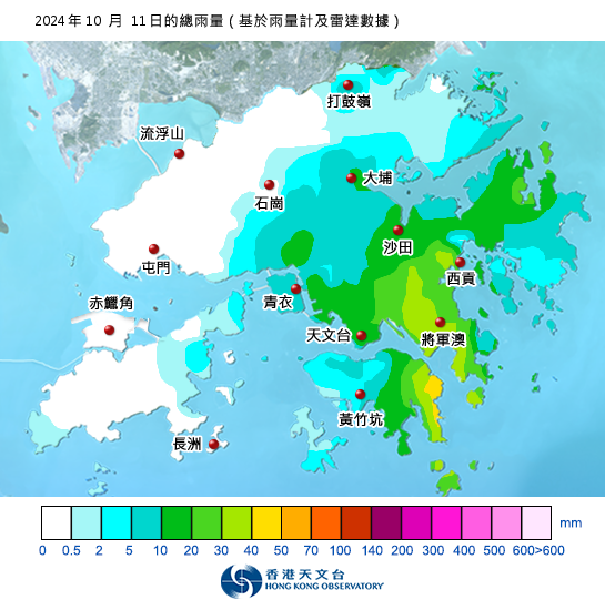
Figure 5 Daily rainfall map of October 11, 2024.
Ever-changing weather patterns and Hong Kong’s complex topography often add uncertainty to the spatial distribution of convective weather. The above are just some examples of isolated showers. When planning outdoor activities, if you notice that the Observatory forecasts isolated showers or thunderstorms for the day, you can open the radar image or the automatic regional rainfall and lightning forecast in the “MyObservatory” app to check if your location or destination may be affected by showers and make arrangements accordingly.
References: