Your Weather Crystal Ball
Your Weather Crystal Ball
TAM Yee-ting
December 2015
Will it be windy and chilly when you go jogging this evening? What is the chance of rain in the next few days? What the wind will be like when you go wind-surfing in the weekend?
Weather forecasters of the Observatory make use of a large amount of observations and forecast data everyday to produce, based on their experience, weather forecasts of Hong Kong in the coming 9 days. As Hong Kong is located at the shore with rather complex terrain, the weather at different locations can often be different. Imagine that you now have a weather “crystal ball” showing the weather forecasts at various locations of Hong Kong. No doubt this would greatly help planning for various activities. This is what the "Automatic Regional Weather Forecast" webpage aims to serve. It features hourly forecasts of temperature, relative humidity, wind direction and wind speed for various locations in Hong Kong for the next 9 days. The webpage was enhanced in December 2015 with the addition of 3-hourly state-of-sky in the form of weather icons and daily probability of precipitation forecasts for certain stations in the territory. Like a "crystal ball", the "Automatic Regional Weather Forecast" webpage offers weather information at locations of your choice. Once you select a location on an interactive map on the webpage, the weather forecasts pertaining to the selected location will be presented in the form of a time series (Figure 1).
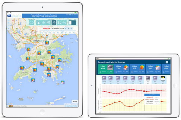
Figure 1 The "Automatic Regional Weather Forecast" webpage (left) and a time series of forecast weather for a location (right)
Mother Nature is full of uncertainties, and hence weather forecasting cannot be totally accurate. While the wisdom and experience of a weather forecaster can hardly be emulated by computers, the number cruncher can nevertheless help consolidate various types of "big data" on weather and generate an objective "guess" of the future weather conditions. Computer models typically represent the atmosphere as stacks of grids (Figure 2). Within each grid, the changes in airflow, pressure, temperature and humidity are governed by physical laws (see this article: Simulating Atmosphere). Computer models first establish the current weather conditions based on observations collected from instruments such as ground weather stations, radar, weather balloons (radiosondes), aircraft, and meteorological satellites, etc., and then generate a forecast. Just as artists have different ways of depicting the world, different models also have different "characters" owing to different weather data input and physical processes represented in the model. For instance, one model may tend to forecast fewer clouds while another may tend to predict larger temperature variation in a day. Hence, the automatic regional weather forecast basically consolidates the forecasts from computer models of the Observatory and several major meteorological centres with adjustments to the direct model outputs to produce a more accurate weather forecast.
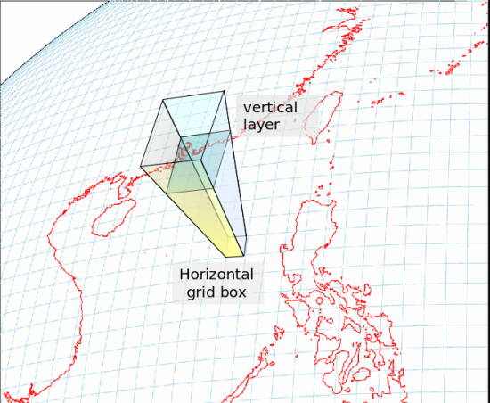
Figure 2 Schematic of three-dimensional grids in a computer weather prediction model
It should be noted that the information on this one-stop-shop portal is generated automatically without any human intervention. What the weather forecasters of the Observatory issued represents a prediction of the overall weather conditions of Hong Kong, whereas the automatic regional weather forecast gives more detailed forecast information, usefully supplementing each other.