Interactions between Tropical Cyclones
Interactions between Tropical Cyclones
Terence KUNG and LAM Ching-chi
July 2015
Entering July this year, tropical cyclone activities over the western North Pacific have been increasing. The satellite imagery in Figure 1 shows that there are a total of three tropical cyclones over the northeastern part of the South China Sea and the western North Pacific. You may wonder: If Chan-hom continues to edge closer to Linfa, what will be the impacts on the latter? Concurrent occurrences of three tropical cyclones happened in the past, but were not many. Some examples in recent years can be found in the HKO's educational material.
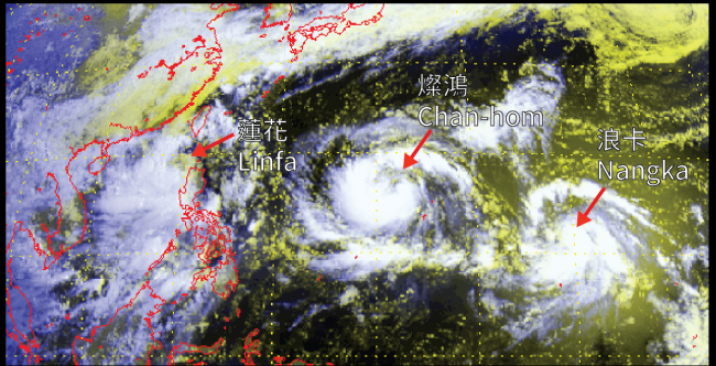
Figure 1 Visible imagery captured at 8 a.m. on 6 July 2015 showing tropical cyclone Linfa over the northeastern part of the South China Sea as well as Chan-hom and Nangka over the western North Pacific. (The image was originally captured by MTSAT-2 of the Japan Meteorological Agency)
Dating back to the 20's to 30's of the last century, Dr. Sakuhei Fujiwhara (1884 - 1950) already discovered that when two tropical cyclones approach each other, they tend to rotate anti-clockwise about a point between them. This phenomenon is usually known as the Fujiwhara effect. Research studies showed that tropical cyclones begin to interact more prominently when their centers come within around 1200 km of each other. The degree of interaction increases as the separation distance decreases[1], while the separation distance where interaction commences depends on the sizes of the tropical cyclones[2]. Other research studies also pointed out that the interaction between two tropical cyclones depends on the sizes and intensities of the tropical cyclones as well as the environmental steering flow; whereas tropical cyclones of unequal sizes likely to have greater interaction than two of similar sizes[3]
When two tropical cyclones come into proximity, it may bring about the following situations:
1. The two tropical cyclones rotate in a stable orbit (Fujiwhara effect), followed by a release and escape (Figure 2). For example in 2009, tropical cyclone Parma near the Philippines interacted with another tropical cyclone Melor, and Parma underwent a looping motion during 5-7 October (Figure 3 and 4).
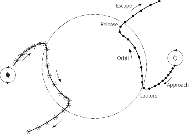
Figure 2 A conceptual model showing interaction of two tropical cyclones: approach and capture, followed by a stable mutual orbit (Fujiwhara effect), then release and escape. The diagram is adapted from Lander and Holland (1993).
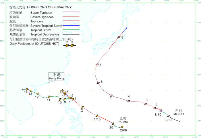
Figure 3 The tracks of tropical cyclones Parma and Melor in September-October 2009.
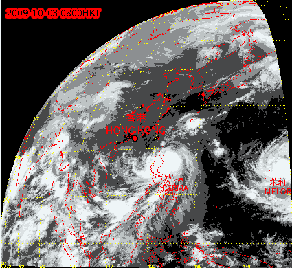
Figure 4 Animation of infra-red satellite imagery showing tropical cyclones Parma and Melor from 3 to 12 October 2009. (HKT is local time, the satellite imagery was originally captured by MTSAT-2 of the Japan Meteorological Agency)
2. One tropical cyclone is captured and "swallowed up" by another tropical cyclone, or the two tropical cyclones undergo a merger (Figure 5). This scenario is most likely to occur when one tropical cyclone is much larger and stronger than the other[4]. Examples are Zeb and Alex in 1998 (Figure 6); Namtheun in 2010 near the Taiwan Strait interacting with Lionrock over the northeastern part of the South China Sea, weakening and dissipating afterwards (Figure 7 and 8).
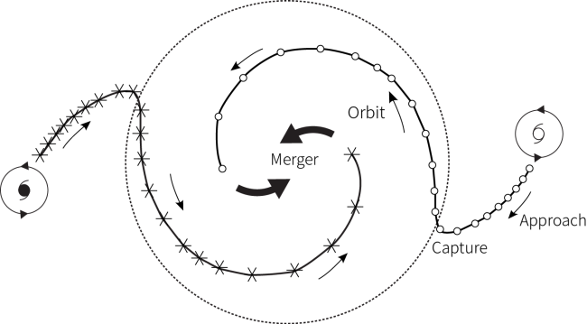
Figure 5 A conceptual model showing interaction of two tropical cyclones. When they orbit and come closer and closer together, they eventually undergo a merger. The diagram is adapted from Lander and Holland (1993).
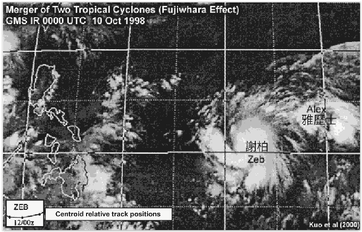
Figure 6 Animation of infra-red satellite imagery showing tropical cyclone Zeb and Alex from 10 to 13 October 1998. (UTC is Coordinated Universal Time, the satellite imagery was originally captured by GMS of the Japan Meteorological Agency. The animation is adapted from the University Corporation for Atmospheric Research (UCAR))
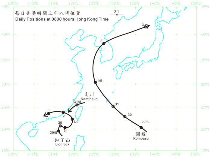
Figure 7 The tracks of tropical cyclones Lionrock, Namtheun and Kompasu in August - September 2010.
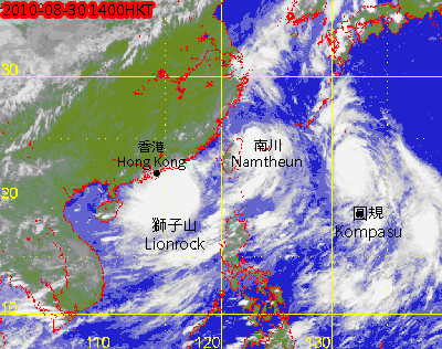
Figure 8 Animation of infra-red satellite imagery showing tropical cyclones Lionrock, Nantheun and Kompasu from 30 August to 1 September 2010. (HKT is local time, the satellite imagery was originally captured by MTSAT-2 of the Japan Meteorological Agency)
3. The two tropical cyclones only exhibit "semi-direct" interaction, and their tracks are largely determined by the steering flow associated with other synoptic weather systems[4][5] (Figure 9).
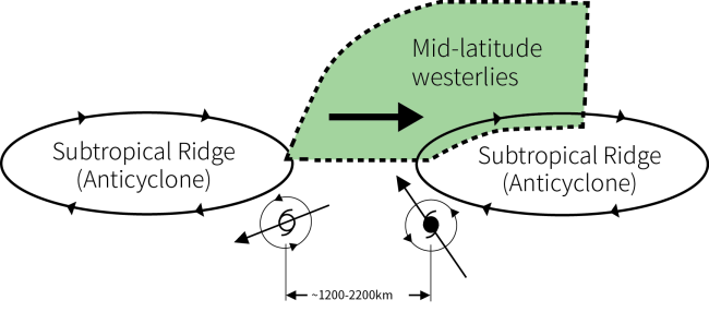
Figure 9 A conceptual model showing other synoptic weather system (e.g. subtropical ridge) provides the main steering flow to the tropical cyclones. The diagram is adapted from Carr and Elsberry (1997).
Whenever there are interactions between two or more tropical cyclones, they will drag each other, rotate, cause one of them weakening, merge together or escape from each other, etc. These are superimposed on the steering flow of the synoptic environment. The tracks of the tropical cyclones will then become rather complex, making forecasts more difficult. Nowadays, we have a grasp of the basic conceptual models, and computer numerical models can also generally capture the interaction processes between tropical cyclones. However, as many factors come into play (including changes in intensities, sizes and relative positions, etc. of the tropical cyclones), there will be discrepancies between different model forecasts, posing great challenges to forecasters. In any case, members of the public are advised to pay close attention to the latest tropical cyclone information and weather forecasts issued by the Observatory.
References:
[1] Brand, S., 1970: Interaction of binary tropical cyclones of the western North Pacific. J. Appl. Meteor.,9, 433–441.
[2] Introduction to Tropical Meteorology, 2nd Edition, Chapter 8: Tropical Cyclones, MetEd (2010) (https://meted.ucar.edu/), COMET Program, UCAR.
[3] Prieto, R., B. D. McNoldy, S. R. Fulton, and W. H. Schubert, 2003: A classification of binary tropical cyclone–like vortex interactions. Mon. Wea. Rev., 131, 2656–2666.
[4] Lander, M. A., and G. J. Holland, 1993: On the interaction of tropical-cyclone-scale vortices. I: Observation. Quart. J. Roy. Meteor. Soc., 119, 1347–1361.
[5] Carr, L.E., III, and R. L. Elsberry, 1997: Objective diagnosis of binary tropical cyclone interactions for the western North Pacific basin. Mon. Wea. Rev., 126, 1734-1740.