Will we find gales under Strong Wind Signal, No. 3?
Will we find gales under Strong Wind Signal, No. 3?
LO Ka-wai, TSE Kwan-shu and YEUNG Hon-yin
October 2022
Tropical Cyclones (TC) may affect Hong Kong generally from May to November (Super Typhoon Rai in December 2021 was an exception) with highest occurrence frequency during July-September. Whenever there is a TC locating within about 800 kilometers of Hong Kong and may affect the territory, the Hong Kong Observatory will assess its impact on the local winds and issue the corresponding TC Warning Signals in a timely manner based on the forecast intensities and tracks of that TC. In general, when strong winds (a sustained wind speed of 41-62 kilometres per hour) are blowing or expected to blow generally in Hong Kong near sea level, and the wind condition is expected to persist, the Hong Kong Observatory will consider issuing the Strong Wind Signal, No.3.
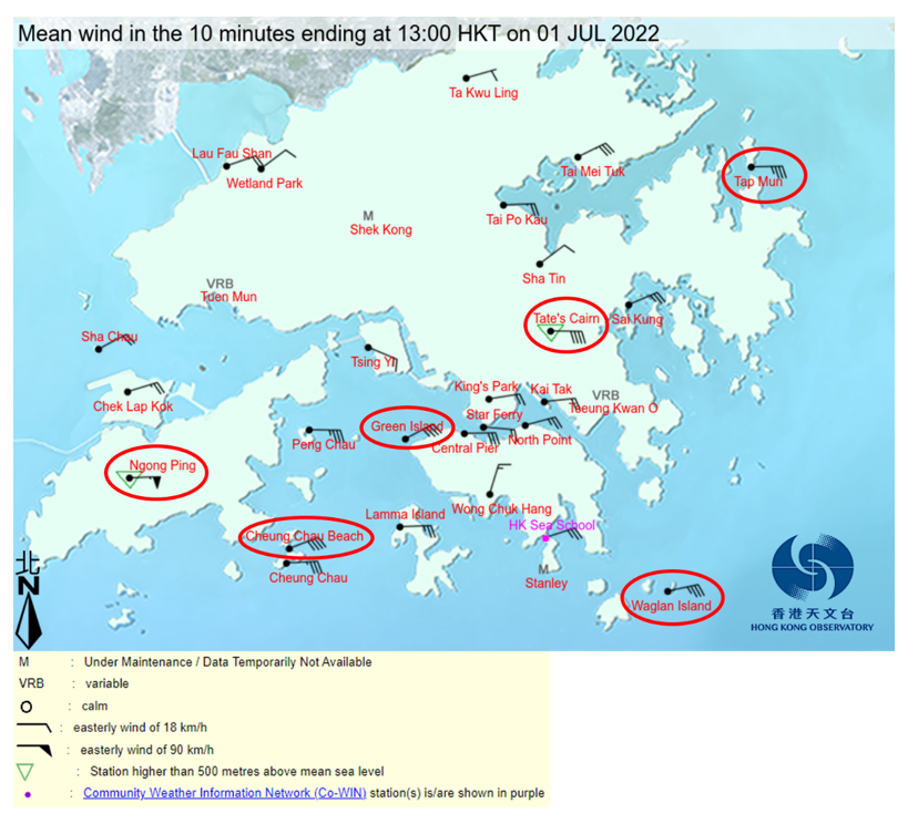
Take TC Chaba as an example. The Observatory issued the Strong Wind Signal, No.3 at 10:40 pm on 30 June 2022. Figure 1 shows the 10-min mean wind direction and speed at 01:00 pm on 1 July 2022. There were strong winds blowing generally over the territory when Strong Wind Signal, No. 3 was in force. Furthermore, gale winds (a sustained wind speed of 63-87 kilometres per hour) or above were recorded in Cheung Chau Beach and Ngong Ping. Why did we find gales under Strong Wind Signal, No.3 over parts of the territory?

Figure 1 10 minutes mean wind direction and speed of Hong Kong at 01:00pm on 1 July 2022. The weather stations with gale winds (10 minutes mean wind speed reached 63 kilometres per hour) or above are circled in red. Please refer to the legend on the bottom left corner for the interpretation of wind barbs.
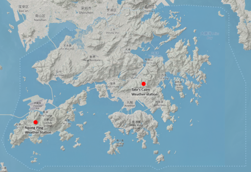
"Winds" refer to the air flow from a region of higher pressure to a region of lower pressure. Movement speed of air flow (i.e. wind speed) would be slowed down due to friction. The friction is generally smaller over sea surface than that over land surface. Together with the fact that there is no obstruction from building nor complicated topography over the sea surface, offshore winds are generally higher than that over land surface, especially in urban areas. Besides, the friction over high grounds are also smaller as they are far away from buildings. In general, the higher the places, the stronger the winds. Apart from “high ground” and “offshore”, the complexity of Hong Kong’s topography (Figure 2), the orientation and density of buildings will also exert local influence to the wind conditions over the landmass of Hong Kong leading up to significant regional differences.

Figure 2 Topography of Hong Kong. The elevation of ground above mean sea-level for Tate’s Cairn and Ngong Ping weather stations are about 572 metres and 593 metres respectively.
Furthermore, the high winds associated with a TC are usually distributed close to its circulation centre (except for the “eye” of a typhoon) and wind speeds decrease with increasing distance from the centre. Referring to Figure 1, Chaba was still centred at about 400 km south-southwest of Hong Kong at that time and the southern parts of the territory, e.g. Cheung Chau and Lantau Island, were situated relatively closer to Chaba’s centre. As such, the wind speeds recorded over there were higher than those over the northern parts of the territory.
Therefore, even if local winds are generally strong under Strong Wind Signal, No. 3, there could still be gale winds over individual locations over offshore waters, on high ground or places that are relatively closer to the centre of a TC. The public should take note of the regional wind information mentioned in TC Warning Bulletin (or make reference directly to the Regional Weather webpage for real-time information on mean wind and maximum gust) and take appropriate response actions, including staying away from the shoreline, not to engage in water sports and avoid visiting high grounds or locations exposing to high winds.