Aerial Radiation Survey
Aerial Radiation Survey
Terence KUNG and CHAN Yuk-hing
July 2021
Monitoring the environmental radiation level in Hong Kong is one of the important missions of the Observatory. Among other things, aerial radiation surveys are conducted routinely in cooperation with the Government Flying Service (GFS). The merit of aerial radiation survey is its ability to measure the radiation levels over remote areas or over regions inaccessible to land transportation.
The Aerial Radiation Monitoring System (ARMS) is a radiation measurement system installed in the helicopter, and is operated by staff of the Observatory on board the helicopter. The system consists of four sodium iodide (NaI) detectors, each about 2.5 litres, for radiation measurements. In 2020, the GFS changed to use the new model “Airbus H175” Cheetah helicopter in the conduct of aerial radiation surveys. On this new model helicopter, the ARMS detectors have changed to be installed inside a black pod attached to the exterior of the helicopter (Figure 1). With this set-up, the detectors are more exposed to the ambient environment as compared to the original mounting location inside the helicopter cabin, thereby increasing the detection efficiency of the environmental radiation level. Furthermore, since the new model helicopter is equipped with the satellite transmission system, radiation measurement data can be transmitted to the Observatory Headquarters in real time.
In the unlikely event of nuclear incident, the radioactive materials released may be dispersed by winds like a cloud of smoke, which we call a “radioactive plume”. During the passage of the plume, radioactive materials might be deposited on the ground, resulting in contamination. As such, the ARMS has two modes of operation. The first mode is used to detect and track the radioactive plume, whilst the other mode is to monitor the radioactive contamination on the ground. The “Plume Tracking” mode normally operates during the early phase of a nuclear incident. The helicopter will conduct a large-scale survey at high altitude to determine the existence and extent of any radioactive plume over Hong Kong. If the radioactive plume has already passed over the territory, the system will have to be switched to operate in the “Ground Contamination Monitoring” mode. Under this mode, the helicopter will maintain at a height of around 100 metres above the ground, and scan intensively over a relatively smaller region in order to identify surface areas contaminated by radiation deposits. The ARMS has rather high sensitivity. During the monitoring, it can analyse and display in real time the measured gamma radiation data and energy spectrum. Meanwhile, it can also display and record the position and time of the collected radiation data using the Global Positioning System of the helicopter.
Every month, the Observatory conducts routine aerial surveys using the ARMS over some waters in Hong Kong (for example, in the vicinity of Ping Chau, Kat O, Tap Mun). Before the survey, staff of the Observatory will determine the flight route and communicate with the GFS. After the survey, the collected data will be analysed in details (Figures 2 and 3). The figures show that the count rates measured near land surface were significantly higher than those measured over the sea surface, as rocks and soil contain significantly more radioactive materials than sea water does. Moreover, irradiation originated from the ground surface will attenuate with distance, therefore the count rates measured by the ARMS decrease rapidly with height from the ground surface. When the height exceeds about 1 kilometre, as cosmic radiation will become higher and higher (please see this article), the count rates will start to increase with height.
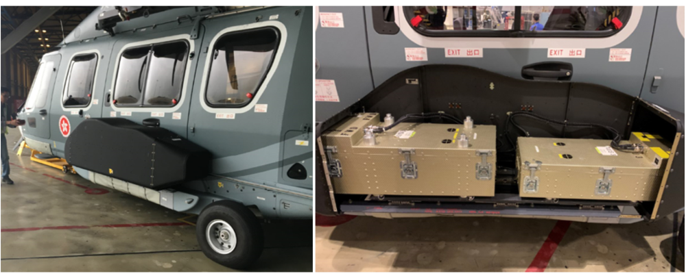
Figure 1 (Left) The ARMS detectors are installed inside a black pod attached to the exterior of the helicopter; (Right) Sodium Iodide (NaI) detectors.
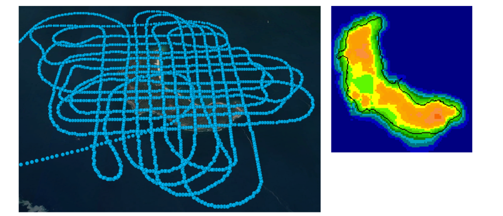
Figure 2 (Left) The helicopter conducted aerial radiation survey over Ping Chau on 20 April 2020. Figure shows the flight route of the helicopter, measuring at about 100 metres above the ground; (Right) Count rates over Ping Chau as measured by the “Ground Contamination Monitoring” mode of the ARMS.
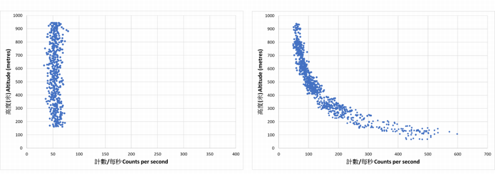
Figure 3 Variation of count rates with height over (Left) Mirs Bay and (Right) the land area of Sai Kung, as measured by the ARMS on 25 February 2020. No artificial radionuclides were detected during the process.