Planes: Special Air Reports
Planes: Special Air Reports
CHEUNG Chun-ngai
January 2023
According to Chapter 5 of ICAO Annex 3 - Meteorological Service for International Air Navigation, aircraft are required to make special observations if they encounter certain hazardous weather phenomena including moderate/severe turbulence or icing. These special observations, called special air reports (ARS), could be used as one of the many valuable sources of information for aviation forecasters to issue accurate forecasts or warnings. The ARS also serve as alerts to other flights along the same flight path.
Special air reports are first provided by pilots to air traffic services (ATS) units through voice communications. Upon the receipt of such reports, the ATS units would relay them without delay to their associated meteorological watch offices (MWOs). In Hong Kong, the information is passed from the air traffic control officers of the Hong Kong Civil Aviation Department to the Airport Meteorological Office (AMO) of Hong Kong Observatory (HKO).
Aviation forecasters at AMO will then encode the information into the ICAO-specified format, and disseminate the ARS as soon as possible via Air Traffic Services Message Handling System (AMHS) to relevant parties around the globe including ATS units, World Area Forecast Centres (WAFCs), MWOs, airlines, etc. The encoded information will also be distributed via VOLMET broadcast/D-VOLMET, which are periodic broadcasts of meteorological information. Aviation forecasters will also assess the intensity and persistence of the phenomenon, then issue Significant Weather Information (SIGMET) when necessary (Figure 1).
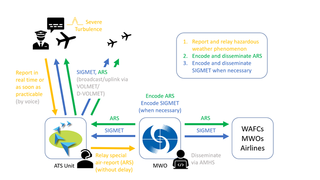
Figure 1 The reception and dissemination process of special air reports.
HKO also receives reports of windshear and turbulence from departing or arriving flights through the aerodrome control tower. Aviation forecasters will make use of such information and consider if there is a need to issue windshear warnings or SIGMETs. Such windshear and turbulence information will also be included in the Aviation Weather Report (METAR/SPECI).
In addition to real time operational usage, ARS are also used for development of aviation hazardous weather forecast products. The collected data help developers understand the climatology of hazardous weather, evaluate the performance of forecast products and improve the forecast accuracy. An example of ARS on March 2016 is illustrated in Figure 2.
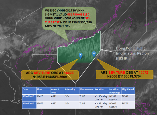
Figure 2 Two cases of severe turbulence reported on 3 March 2016. The first ARS was received at 1642Z. A SIGMET with severe turbulence forecast was then issued by AMO for the period 1730 to 2130Z. A second ARS was then received from another aircraft operating in that region at 1907Z when the SIGMET was in force. The satellite image showed transverse cloud bands over the area indicating the presence of turbulence.