Decoding Aviation Weather Report (METAR/SPECI)
METAR is routine weather report issued at hourly or half-hourly intervals. It is a description of the meteorological elements observed at an airport at a specific time.
SPECI is special weather report issued when there is significant deterioration or improvement in airport weather conditions, such as significant changes of surface winds, visibility, cloud base height and occurrence of severe weather. The format of the SPECI report is similar to that of the METAR and the elements used have the same meaning. The identifier METAR or SPECI at the beginning of the weather report differentiates them.
A METAR/SPECI report usually contains the following information:
Originating airport name, METAR/SPECI issue time, wind direction/speed/gust, wind direction variation, visibility, runway visual range, weather during time of observation, cloud, air temperature/dew-point, QNH (pressure measured at airport with adjustment made to suit aeronautical use), weather during the past hour but not at time of observation, wind shear information, trend-type landing forecast.
| Visibility : | 9999 = 10 km or above, 7000 = 7 km, 0000 = less than 50 m |
| CAVOK = sky and visibility OK | |
| As a result of an amendment by the International Civil Aviation Organization starting from 1 November 2001, the night-time visibility for aviation purpose represents the greatest distance at which light in the vicinity of 1 000 candelas can be seen and identified against an unlit background. As it is made specifically for aviation purpose, it may occasionally differ from the night-time visibility for general purpose which represents the degree of atmospheric transparency and is independent of the intensity of lights being observed. |
Runway visual range (RVR) : e.g. R07L* /0800N = runway 07 left, RVR 800 m and without distinct change
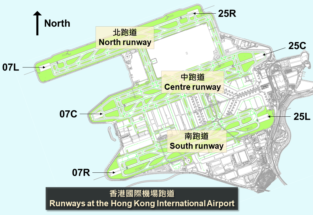
* There are three parallel runways at the Hong Kong International Airport and they are identified by the designators R07L/R25R, R07C/R25C and R07R/R25L respectively as shown below :
| Weather : | - = light, + = heavy, VC = vicinity, MI = shallow, BC = patches, |
| SH = showers, PR = partial, TS = thunderstorms, | |
| DZ = drizzle, RA = rain, BR = mist, FG = fog, HZ = haze, | |
| +SHRA = heavy showers of rain, | |
| -DZ = light drizzle |
|
| Cloud : | cloud amount given in eighths of sky (oktas) covered where |
| FEW = 1 to 2 oktas, SCT = 3 to 4 oktas, BKN = 5 to 7 oktas, | |
| OVC = 8 oktas and SKC = sky clear |
Wind shear information : e.g. WS RWY07L = wind shear occurring at runway 07 left
The code includes a section containing the trend forecast, which indicates the forecast change in meteorological conditions in the next two hours and is identified by a change indicator (TTTTT = BECMG or TEMPO as the case may be) or by the code word NOSIG. (BECMG means becoming; TEMPO means temporarily; NOSIG means no significant change.)
| okta(s) : | the international unit for reporting cloud amount. Cloud amount is assessed in total which is the estimated total apparent area of the sky covered with cloud. |
| Example : | METAR VHHH 251600Z 24015G25KT 200V280 0600 R07L/1000U FG DZ SCT010 OVC020 17/16 Q1018 BECMG TL1700 0800 FG BECMG AT 1800 9999 NSW= |
| Decoded as : |
| CODE | MEANING |
| METAR VHHH | METAR issued by the Hong Kong International Airport |
| 251600Z | At 1600 UTC, the 25th of the month |
| 24015G25KT | surface wind direction 240 degrees (west-southwestly winds), wind speed 15 knots, gusting to 25 knots |
| 200V280 | wind direction variation 200 to 280 degrees |
| 0600 R07L/1000U | visibility 600 m; runway visual range representative of the touchdown zone for left one of runway 07 is 1000 m and the runway visual range values have shown an upward tendency during previous 10 minutes |
| FG DZ | fog and drizzle |
| SCT010 OVC020 | scattered cloud at 1000 ft; overcast cloud layer at 2000ft |
| 17/16 Q1018 | air temperature 17 degree Celsius; dew point 16 degree Celsius; QNH 1018 hpa |
| BECMG TL1700 0800 FG | trend during the next 2 hours; visibility becoming 800m in fog by 1700 UTC |
| BECMG AT 1800 9999 NSW | at 1800 UTC visibility becoming 10 km or above with nil significant weather |