Impact of sand and dust storms on aviation safety
Impact of sand and dust storms on aviation safety
YIM Ka-yee
January 2021
There are some famous deserts in western and northern China and Mongolia. In the spring time from March to May, when there are strong winds coupled with unstable atmosphere, for example the passage of strong cold fronts, sandstorms may occur due to dry weather and sparse vegetation on the ground. In some cases, the raised sand can reach several kilometers in height and can be transported by upper airstream to thousands of kilometers away. The process may last up to a week until the wind subsides. On 10 to 11 April 2020, sandstorm weather over Tarim Basin, Xinjiang, China is an example of sandstorm triggered by cold air advection activities.
Sand and dust weather caused by rolling up of sand and dust obscures visibility and affects takeoffs and landings, causing flight delay, cancellation and diversion to other airports. Besides, static charge built up by sand particles in the air may interfere with aircraft instruments and cause communication failure. Sucking sand and dust into the turbine engine will cause erosion of the engine and performance degradation which may lead to flight accident.
In order to ensure flight safety, all aviation meteorological offices monitor sand and dust weather. Sand and dust weather can be classified into four levels, namely ‘dust or sand’, ‘blowing dust or sand’, 'duststorm or sandstorm’, ‘heavy duststorm or sandstorm’. In case of heavy duststorms or sandstorms, aviation meteorological offices will issue Significant Weather Information (SIGMETs) and/or aerodrome warnings to ensure flight safety. The Hong Kong Observatory makes use of weather observations, satellite images and air trajectories to monitor sand and dust weather. Please refer to the “Sand and Dust Weather Information” webpage for details.
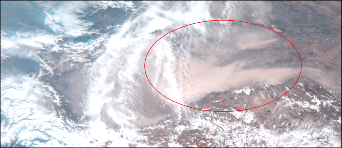
Figure 1 Satellite image (True Color) of Xinjiang, China on April 10, 2020. Circled areas were affected by sand and dust weather. The visibility was down to 400m.
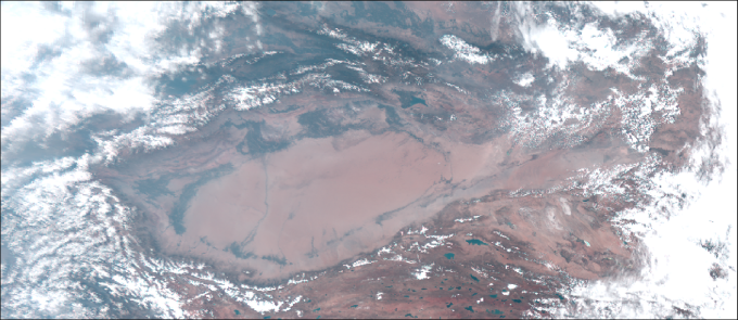
Figure 2 Satellite image (True Color) of Xinjiang, China on July 24, 2020. The visibility was normal on this day.