Sand and Dust Weather Information - Q & A for sand and dust weather
What is a sandstorm/duststorm?
A sandstorm or duststorm is a meteorological phenomenon usually caused by strong and turbulent winds blowing over loose soil or sand and sweeping up large quantities of sand or dust particles from the ground, clouding the air and reducing the visibility drastically. In desert regions, the abundance of loose sand and the instability of atmosphere due to strong solar heating favour the formation of sandstorm/duststorm.
In general, sandstorm/duststorm can be defined as an ensemble of particles of sand and dust energetically lifted to great heights by a strong and turbulent wind bringing visibility down to less than 1,000 metres. If the visibility is observed to be 1,000 metres or greater it would be defined as sand or dust. Most sand and dust related weather in East Asia originates in western China, northern China and Mongolia and occurs mainly in spring, typically between March and May.
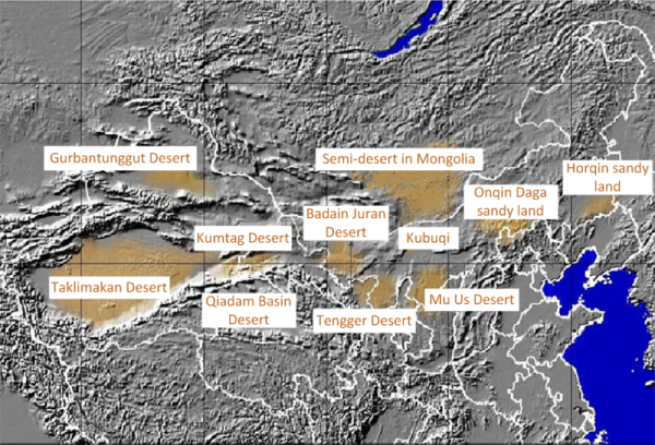
Sources of sandstorm/duststorm in East Asia.
Will sandstorm/duststorm occur in Hong Kong ?
Dust plumes in northern China can be carried eastward by airstream to places such as Japan, Korea and the North Pacific. As a sandstorm moves along, sand particles will settle progressively and thus the particulate concentration will drop progressively. Being thousands of kilometres away from the deserts in the north, sandstorms from the north would have lost most if not all their characteristics by the time sand and dust arrived at Hong Kong. Therefore, Hong Kong is very unlikely to experience the adverse condition as the north does during a sandstorm.
In March 2010, China experienced one of the most severe sandstorms in recent years. On 18 March, sandstorms developed over Mongolia under the influence of strong winds. In the following few days, the sandstorms spread to affect northern, central and eastern China, as well as Korea and Japan. The sandstorms had lost most of their characteristics by the time sand and dust arrived at the coastal areas of Guangdong on 21 March after passing through Taiwan Strait. The sand and dust took the visibility down to between 2,000 and 4,000 metres over most parts of Hong Kong. Haze was reported generally over the coastal areas of Guangdong.
How does the Observatory monitor the sand and dust weather ?
There are several tools:-
-
Weather observation
The Observatory monitors the weather observation reported at weather centres in the neighbouring areas, including Chinese Mainland, Korea, Japan and Taiwan, China. Please click here for any latest reports of sand and dust related weather. -
Satellite images
Data processing techniques are available to discern areas where sand or dust may be present in the atmosphere based on data received from meteorological satellites. In the following example, the identified areas of potential sand or dust are highlighted in yellow to red colours. Please click here for the latest satellite images for sand and dust monitoring.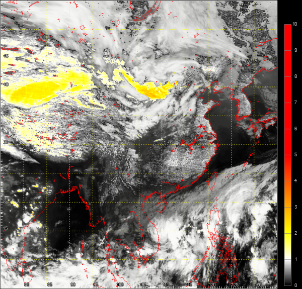
Post-processed satellite image at 20HKT on 10 November 2010 showing possible regions (highlighted in yellow to red colours) over northern China which were affected by sand and dust weather.
Users should note that the satellite data processing techniques will be more effective under cloud free conditions as clouds may mask underlying sand or dust. A high concentration of water vapour in the atmosphere could also affect the identification of sand or dust. Thunderstorms may sometimes appear in yellow colour in this satellite product.
-
Trajectories of air
A trajectory enables one to appreciate the possible origin, 72 hours ago, of the air arriving at Hong Kong. From these trajectories, one can relate the local visibility to the possible origin of the air 72 hours ago. There are however limitations to the application of this tool to monitor sand and dust because it offers at best a qualitative (i.e. not quantitative) assessment, for sand and dust are different from air in terms of their physical characteristics and may not necessarily follow the same trajectory as that for air. Please visit the webpages on the trajectory of air that has reached Hong Kong and the trajectory of air which is forecast to reach Hong Kong.