A Farewell to El Niño
31 May 2016
Everything has its end. The longest and strongest El Niño event since 1950 is finally coming to an end, returning back to normal atmospheric and oceanic conditions (i.e. neither an El Niño nor a La Niña in place, or called ENSO-neutral state) this summer. While it is time to say goodbye to El Niño, we may need to welcome La Niña very soon. According to the latest observations and forecasts by a number of climate models around the world, there is an increasing chance that La Niña may start to develop in the latter part of the year. This has raised concerns from the public and media about the impact of La Niña on the weather of Hong Kong in the latter part of this year.
La Niña refers to the cooling of surface waters over the central and eastern equatorial Pacific Ocean which affects the atmospheric circulation worldwide and regional climate in many parts of the world. When La Niña is active during August to October, tropical cyclones in the vicinity of the Philippines are likely driven by an anomalous steering flow into the South China Sea and hence more tropical cyclones are likely to affect Hong Kong as compared with the ENSO-neutral state. According to past statistics, there could still be more than one tropical cyclone on average affecting Hong Kong in October under La Niña conditions (Figure 1). In other words, the tropical cyclone season may end later than in ENSO-neutral years or El Niño years.
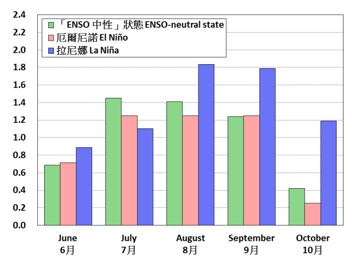
Figure 1Number of tropical cyclones coming within 500 km of Hong Kong in June-October during 1961-2015.
Regarding the impact of La Niña on the temperature in Hong Kong, although we may experience high temperatures when a tropical cyclone approaches Hong Kong, the effect will be short term and such impact to the mean temperature for the latter part of the year would be minimal. On the contrary, based on past statistics, the northeast monsoon affecting southern China is generally stronger in autumn (September-November) and winter (December-February) during La Niña, bringing lower temperatures to Hong Kong as compared with the ENSO-neutral state (Figure 2).
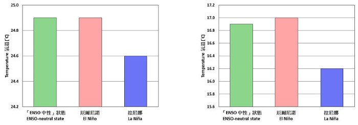
Figure 1Autumn (September-November, left) and winter (December-February, right) temperatures of Hong Kong during 1950-2015.
Of course, whether the weather in the latter part of this year would follow the aforementioned pattern still depends on the development of La Niña and the influence of other factors.
For more information on El Niño and La Niña, please visit the Observatory webpage:
http://www.hko.gov.hk/lrf/enso/enso-latest.htm
F C Sham and H W Tong
La Niña refers to the cooling of surface waters over the central and eastern equatorial Pacific Ocean which affects the atmospheric circulation worldwide and regional climate in many parts of the world. When La Niña is active during August to October, tropical cyclones in the vicinity of the Philippines are likely driven by an anomalous steering flow into the South China Sea and hence more tropical cyclones are likely to affect Hong Kong as compared with the ENSO-neutral state. According to past statistics, there could still be more than one tropical cyclone on average affecting Hong Kong in October under La Niña conditions (Figure 1). In other words, the tropical cyclone season may end later than in ENSO-neutral years or El Niño years.
Figure 1Number of tropical cyclones coming within 500 km of Hong Kong in June-October during 1961-2015.
Regarding the impact of La Niña on the temperature in Hong Kong, although we may experience high temperatures when a tropical cyclone approaches Hong Kong, the effect will be short term and such impact to the mean temperature for the latter part of the year would be minimal. On the contrary, based on past statistics, the northeast monsoon affecting southern China is generally stronger in autumn (September-November) and winter (December-February) during La Niña, bringing lower temperatures to Hong Kong as compared with the ENSO-neutral state (Figure 2).
Figure 1Autumn (September-November, left) and winter (December-February, right) temperatures of Hong Kong during 1950-2015.
Of course, whether the weather in the latter part of this year would follow the aforementioned pattern still depends on the development of La Niña and the influence of other factors.
For more information on El Niño and La Niña, please visit the Observatory webpage:
http://www.hko.gov.hk/lrf/enso/enso-latest.htm
F C Sham and H W Tong