Super Typhoons in 2015
29 January 2016
Under the effect of climate change, there are changes in the frequency, intensity, spatial extent, duration and timing of extreme weather events. In 2015, besides the local and global record breaking temperatures, tropical cyclone activities in the western North Pacific, especially the occurrences of super typhoons, were also eye-catching news that captured the attention of both the media and the public. For example, the havoc wreaked by Super Typhoon Soudelor in Taiwan and the "twin typhoons" of Goni and Atsani in August 2015 hit the headlines of local as well as overseas newspapers. But are super typhoon activities actually more frequent in the western North Pacific (WNP) basin in 2015 ?
Before turning to tropical cyclone statistics, let us first of all re-visit what is meant by "Super Typhoon". Tropical cyclone intensity is classified in accordance with the World Meteorological Organization's recommendation by the maximum sustained wind speeds near the centre. "Typhoon" in a generic sense represents the most intense cyclones under the classification scheme in WNP[1]. However, meteorological services and warning centres in WNP have since adopted different sub-classification schemes within the "Typhoon" category in defining "Super Typhoon" or similar terms (Table 1)[2]. We need to recognize such differences in the interpretation of "Super Typhoon" statistics compiled and reported from various sources.
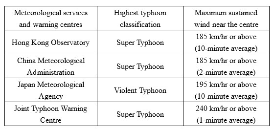
Table 1Definition of "Super Typhoon" (or similar terms) among various meteorological
services and warning centres in WNP.
In Hong Kong, a typhoon with maximum sustained winds (10-minute average) of 185 km/hr or above near its centre is classified as a "Super Typhoon". For WNP and the South China Sea in 2015, there were altogether 13 super typhoons according to the definition of the Hong Kong Observatory[3], eight more than the long-term (1961-2010) yearly average of about five and making it the most active super typhoon year since comprehensive record began in 1961.
Tropical cyclone relies on moisture as its energy source and its intensity change is affected by the atmospheric conditions[4] and the underlying sea surface temperature along its path. As such, more super typhoons in 2015 can partly be attributed to the current El Niño event. As previously discussed in the blog article "No Tropical Cyclone Warning Signals in August and September", the above-normal sea surface temperature over the central and eastern equatorial Pacific results in abnormal atmospheric circulation over the Pacific and in turn displaces the breeding ground of tropical cyclones in the WNP further east. Figure 1 shows that the tropical cyclone genesis positions in 2015 were indeed located further east, with a majority of them forming to the east of 140o E, including all 13 super typhoons and two crossing the dateline and entering WNP (hence bearing non-WNP "foreign" names: Halola and Kilo). Moving typically west to northwestwards after genesis, tropical cyclones forming further east will stay over the oceans longer during their lifespan, thereby increasing the chance for them to develop into super typhoons under relatively high sea surface temperature and favourable atmospheric conditions.
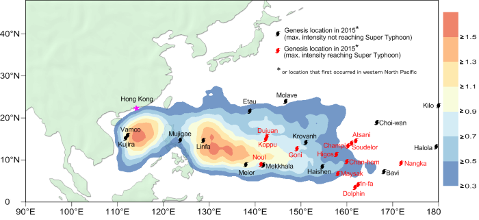
Figure 1Tropical cyclone genesis position in 2015. The shaded area in the background corresponds to
the long term average (1961-2010) of tropical cyclone genesis distribution.
CHOY Chun-wingWU Man-chi
References:
[1] World Meteorological Organization Technical Document, Tropical Cyclone Programme, Report No. TCP-23, Typhoon Committee Operational Manual, Meteorological Component, 2014 Edition
[2] For details, please refer to the website of ESCAP/WMO Typhoon Committee, http://www.typhooncommittee.org/tropical-cyclone-classification/
[3] These 13 Super Typhoons are Higos, Maysak, Noul, Dolphin, Chan-hom, Nangka, Soudelor, Atsani, Goni, Dujuan, Koppu, Champi and In-fa.
[4] The suitable atmospheric conditions include weak vertical wind shear, sufficient lower levels convergence, upper level divergence and moisture transport, etc.
Before turning to tropical cyclone statistics, let us first of all re-visit what is meant by "Super Typhoon". Tropical cyclone intensity is classified in accordance with the World Meteorological Organization's recommendation by the maximum sustained wind speeds near the centre. "Typhoon" in a generic sense represents the most intense cyclones under the classification scheme in WNP[1]. However, meteorological services and warning centres in WNP have since adopted different sub-classification schemes within the "Typhoon" category in defining "Super Typhoon" or similar terms (Table 1)[2]. We need to recognize such differences in the interpretation of "Super Typhoon" statistics compiled and reported from various sources.
Table 1Definition of "Super Typhoon" (or similar terms) among various meteorological
services and warning centres in WNP.
In Hong Kong, a typhoon with maximum sustained winds (10-minute average) of 185 km/hr or above near its centre is classified as a "Super Typhoon". For WNP and the South China Sea in 2015, there were altogether 13 super typhoons according to the definition of the Hong Kong Observatory[3], eight more than the long-term (1961-2010) yearly average of about five and making it the most active super typhoon year since comprehensive record began in 1961.
Tropical cyclone relies on moisture as its energy source and its intensity change is affected by the atmospheric conditions[4] and the underlying sea surface temperature along its path. As such, more super typhoons in 2015 can partly be attributed to the current El Niño event. As previously discussed in the blog article "No Tropical Cyclone Warning Signals in August and September", the above-normal sea surface temperature over the central and eastern equatorial Pacific results in abnormal atmospheric circulation over the Pacific and in turn displaces the breeding ground of tropical cyclones in the WNP further east. Figure 1 shows that the tropical cyclone genesis positions in 2015 were indeed located further east, with a majority of them forming to the east of 140o E, including all 13 super typhoons and two crossing the dateline and entering WNP (hence bearing non-WNP "foreign" names: Halola and Kilo). Moving typically west to northwestwards after genesis, tropical cyclones forming further east will stay over the oceans longer during their lifespan, thereby increasing the chance for them to develop into super typhoons under relatively high sea surface temperature and favourable atmospheric conditions.
Figure 1Tropical cyclone genesis position in 2015. The shaded area in the background corresponds to
the long term average (1961-2010) of tropical cyclone genesis distribution.
CHOY Chun-wingWU Man-chi
References:
[1] World Meteorological Organization Technical Document, Tropical Cyclone Programme, Report No. TCP-23, Typhoon Committee Operational Manual, Meteorological Component, 2014 Edition
[2] For details, please refer to the website of ESCAP/WMO Typhoon Committee, http://www.typhooncommittee.org/tropical-cyclone-classification/
[3] These 13 Super Typhoons are Higos, Maysak, Noul, Dolphin, Chan-hom, Nangka, Soudelor, Atsani, Goni, Dujuan, Koppu, Champi and In-fa.
[4] The suitable atmospheric conditions include weak vertical wind shear, sufficient lower levels convergence, upper level divergence and moisture transport, etc.