No tropical cyclone warning signal in August and September
4 November 2015
August and September are normally the peak months of tropical cyclone activity in Hong Kong with an average of about three tropical cyclones (TCs) affecting Hong Kong, necessitating the issuance of tropical cyclone warning signals[1]. However, in 2015, no tropical cyclone warning signal was issued in August and September, the first time since 1946. So what are the reasons behind this "no TC warning" phenomenon?
Less tropical cyclones entering the South China Sea from the western North Pacific
Firstly, except Soudelor and Dujuan, all TCs formed over the western North Pacific (WNP) in August and September this year (Figure 1) recurved to the north and did not enter the South China Sea (SCS). Even for Soudelor and Dujuan which entered the SCS, they weakened after moving across Taiwan and Fujian and did not directly affect Hong Kong. The reason for less TCs from WNP entering the SCS can be mainly attributed to the current El Nino event. Some studies[2,3] suggest that the above normal sea surface temperature over the central and eastern equatorial Pacific in El Nino years displaces the breeding ground of TC in the WNP further east (Figure 2). This increases the chance for TCs to recurve and turn northwards when moving across the WNP, resulting in less TCs entering the SCS.
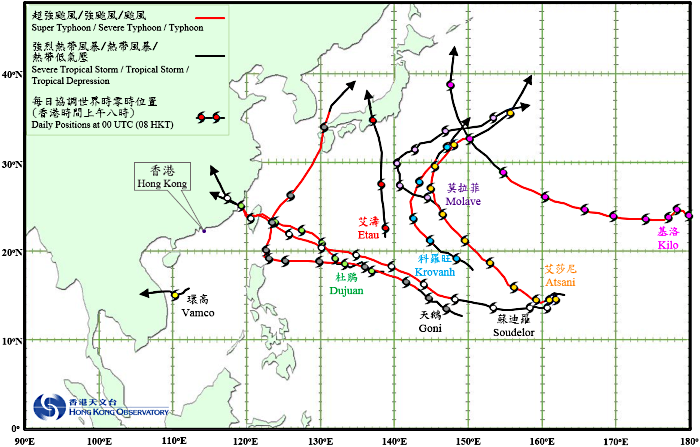
Figure 1Tropical cyclone tracks in August and September 2015
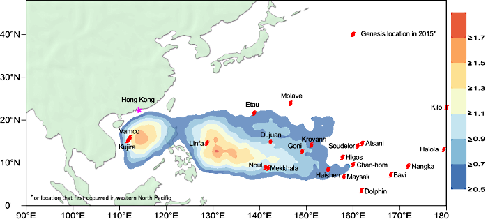
Figure 2Tropical cyclone genesis positions for January - September 2015.
Distribution of the long-term average[1] of tropical cyclone genesis
for January - September is shown in shaded colour.
Less tropical cyclones forming in the South China Sea
Secondly, only one tropical cyclone (Vamco) formed in the SCS in August and September 2015, less than the long-term average of two to three[1]. Vamco moved towards Vietnam and did not directly affect Hong Kong as well. Less TCs forming in the SCS in August and September 2015 was mainly due to the weaker than normal southwesterly airstream over the SCS. This led to less moisture transport and weaker convergence zone in the SCS, which in turn hindered the formation of TCs in the region.
CHOY Chun-wing and WU Man-chi
References:
[1] Long-term average of 1961 to 2010
[2] Goh, A. Z.-C. and Chan, J. C. L., 2010: Interannual and interdecadal variations of tropical cyclone activity in the South China Sea. Int. J. Climatol., 30: 827-843
[3] 厄爾尼諾與西北太平洋的熱帶氣旋,陳營華、張文瀾、胡文志、區展衡,發表於第十二屆粵港澳重要天氣研討會,香港,一九九八年一月十五至十七日 (Chinese version only)
Less tropical cyclones entering the South China Sea from the western North Pacific
Firstly, except Soudelor and Dujuan, all TCs formed over the western North Pacific (WNP) in August and September this year (Figure 1) recurved to the north and did not enter the South China Sea (SCS). Even for Soudelor and Dujuan which entered the SCS, they weakened after moving across Taiwan and Fujian and did not directly affect Hong Kong. The reason for less TCs from WNP entering the SCS can be mainly attributed to the current El Nino event. Some studies[2,3] suggest that the above normal sea surface temperature over the central and eastern equatorial Pacific in El Nino years displaces the breeding ground of TC in the WNP further east (Figure 2). This increases the chance for TCs to recurve and turn northwards when moving across the WNP, resulting in less TCs entering the SCS.
Figure 1Tropical cyclone tracks in August and September 2015
Figure 2Tropical cyclone genesis positions for January - September 2015.
Distribution of the long-term average[1] of tropical cyclone genesis
for January - September is shown in shaded colour.
Less tropical cyclones forming in the South China Sea
Secondly, only one tropical cyclone (Vamco) formed in the SCS in August and September 2015, less than the long-term average of two to three[1]. Vamco moved towards Vietnam and did not directly affect Hong Kong as well. Less TCs forming in the SCS in August and September 2015 was mainly due to the weaker than normal southwesterly airstream over the SCS. This led to less moisture transport and weaker convergence zone in the SCS, which in turn hindered the formation of TCs in the region.
CHOY Chun-wing and WU Man-chi
References:
[1] Long-term average of 1961 to 2010
[2] Goh, A. Z.-C. and Chan, J. C. L., 2010: Interannual and interdecadal variations of tropical cyclone activity in the South China Sea. Int. J. Climatol., 30: 827-843
[3] 厄爾尼諾與西北太平洋的熱帶氣旋,陳營華、張文瀾、胡文志、區展衡,發表於第十二屆粵港澳重要天氣研討會,香港,一九九八年一月十五至十七日 (Chinese version only)