From monsoon depression to tropical cyclone
4 October 2013
In the Observatory's Blog of 3 July this year, we talked about monsoon depression, mentioning how it may develop into a tropical cyclone under favourable atmospheric conditions. Let us talk more on this topic now.
In terms of structures, monsoon depression and tropical depression exhibited quite different characteristics. Generally speaking, convections near the centre of a monsoon depression are relatively weak while high winds are often found at its periphery. For a mature tropical cyclone, however, convections near the centre are stronger and sustained, and the region of high winds is concentrated near its centre. Therefore, when a monsoon depression develops into a tropical cyclone, its structure will evolve throughout the transition process.
On many occasions, more than one circulation centres can be found in a monsoon depression. Some of them may weaken while some may intensify. Intensification of a monsoon depression requires favourable atmospheric environment, such as weak vertical wind shear (no significant differences in wind directions or speeds between upper and lower levels of the atmosphere), abundant moisture supply and higher sea temperature. If convections near one of the circulation centres of a monsoon depression become stronger and sustained, the monsoon depression may intensify into a tropical cyclone. The region of high winds of this kind of tropical cyclone is usually located around the periphery at the initial stage of development. When convections near the centre continue to develop, the region of strongest winds will shift gradually from the periphery towards the centre. The whole system will further intensify and develop into a mature tropical cyclone.
Taking Tropical Cyclone Jebi that affected Hong Kong in early August this year as an example, it originated from a broad cluster of clouds associated with a monsoon depression over the central part of the South China Sea. In the morning of 30 July (Figure 1), the cloud cluster near its centre was loosely organized, typical of a monsoon depression. On 31 July, the system gradually developed into a tropical cyclone. The Observatory issued the Standby Signal No. 1 and Strong Wind Signal No. 3 in the morning and the afternoon of 1 August respectively. Jebi attained the intensity of tropical storm on that day, but the convections near its centre were still not very well-organized. Convections over its western part were more active while there were fewer clouds to the east (Figure 2). Winds along the periphery of Jebi were rather strong, which was common for those tropical cyclones developed from monsoon depressions. Although the centre of Jebi was more than 600 kilometres from Hong Kong on that day, its outer rainbands already brought strong winds to parts of the territory. On 2 August, Jebi further intensified into a severe tropical storm, with more organized and sustained convections near the centre (Figure 3). Jebi skirted more than 400 km southwest of Hong Kong on 2 August night. In the process of intensification, the region of high winds shifted gradually towards its centre. As Hong Kong was located near the periphery of Jebi at that time, winds over the territory weakened while Jebi was actually intensifying. The Observatory cancelled all Tropical Cyclone Warning Signals at 10:15 p.m.
L.S. Lee, C.T. Shum
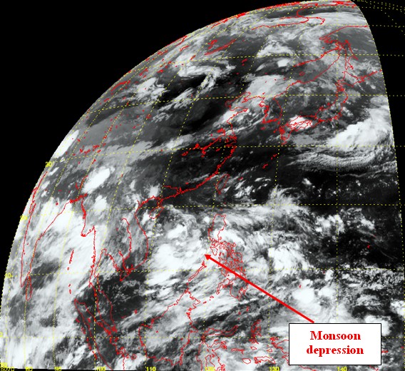
Figure 1Infrared satellite imagery at 8 a.m. on 30 July 2013, showing the monsoon depression over the
central part of the South China Sea (Source: Japan Meteorological Agency).
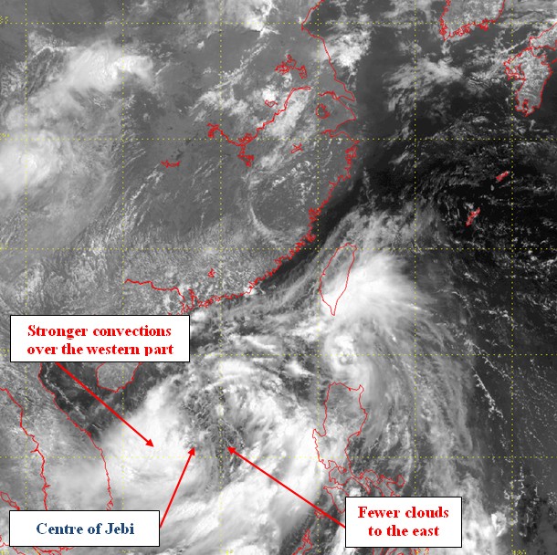
Figure 2Visible satellite imagery at 11 a.m. on 1 August. Jebi was then a tropical storm, with stronger
convections over the western part and significantly weaker convections to the
east (Source: Japan Meteorological Agency).
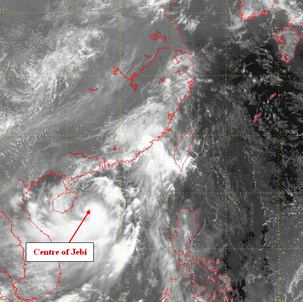
Figure 3Visible satellite imagery at 11 a.m. on 2 August. Jebi was a severe tropical storm at that time, with
convections clustering near its centre (Source: Japan Meteorological Agency).
In terms of structures, monsoon depression and tropical depression exhibited quite different characteristics. Generally speaking, convections near the centre of a monsoon depression are relatively weak while high winds are often found at its periphery. For a mature tropical cyclone, however, convections near the centre are stronger and sustained, and the region of high winds is concentrated near its centre. Therefore, when a monsoon depression develops into a tropical cyclone, its structure will evolve throughout the transition process.
On many occasions, more than one circulation centres can be found in a monsoon depression. Some of them may weaken while some may intensify. Intensification of a monsoon depression requires favourable atmospheric environment, such as weak vertical wind shear (no significant differences in wind directions or speeds between upper and lower levels of the atmosphere), abundant moisture supply and higher sea temperature. If convections near one of the circulation centres of a monsoon depression become stronger and sustained, the monsoon depression may intensify into a tropical cyclone. The region of high winds of this kind of tropical cyclone is usually located around the periphery at the initial stage of development. When convections near the centre continue to develop, the region of strongest winds will shift gradually from the periphery towards the centre. The whole system will further intensify and develop into a mature tropical cyclone.
Taking Tropical Cyclone Jebi that affected Hong Kong in early August this year as an example, it originated from a broad cluster of clouds associated with a monsoon depression over the central part of the South China Sea. In the morning of 30 July (Figure 1), the cloud cluster near its centre was loosely organized, typical of a monsoon depression. On 31 July, the system gradually developed into a tropical cyclone. The Observatory issued the Standby Signal No. 1 and Strong Wind Signal No. 3 in the morning and the afternoon of 1 August respectively. Jebi attained the intensity of tropical storm on that day, but the convections near its centre were still not very well-organized. Convections over its western part were more active while there were fewer clouds to the east (Figure 2). Winds along the periphery of Jebi were rather strong, which was common for those tropical cyclones developed from monsoon depressions. Although the centre of Jebi was more than 600 kilometres from Hong Kong on that day, its outer rainbands already brought strong winds to parts of the territory. On 2 August, Jebi further intensified into a severe tropical storm, with more organized and sustained convections near the centre (Figure 3). Jebi skirted more than 400 km southwest of Hong Kong on 2 August night. In the process of intensification, the region of high winds shifted gradually towards its centre. As Hong Kong was located near the periphery of Jebi at that time, winds over the territory weakened while Jebi was actually intensifying. The Observatory cancelled all Tropical Cyclone Warning Signals at 10:15 p.m.
L.S. Lee, C.T. Shum
Figure 1Infrared satellite imagery at 8 a.m. on 30 July 2013, showing the monsoon depression over the
central part of the South China Sea (Source: Japan Meteorological Agency).
Figure 2Visible satellite imagery at 11 a.m. on 1 August. Jebi was then a tropical storm, with stronger
convections over the western part and significantly weaker convections to the
east (Source: Japan Meteorological Agency).
Figure 3Visible satellite imagery at 11 a.m. on 2 August. Jebi was a severe tropical storm at that time, with
convections clustering near its centre (Source: Japan Meteorological Agency).