How much do you know about monsoon depression?
3 July 2013
During summer, you may hear mentioning of low pressure area in the weather bulletin of the Observatory, for example, 'An area of low pressure is bringing unsettled weather to the northern part of the South China Sea.' When the low pressure area shows signs of intensification into a tropical cyclone, one may hear 'Pressure is rather low over the central part of the South China Sea, where a tropical depression appears to be forming'. Simply speaking, a low pressure area is a region where the pressure is lower than its surroundings such that closed isobar can be analysed on the surface weather chart. Based on its characteristics, low pressure area can be further classified into monsoon depression, frontal depression, etc. In this blog, let us talk about the monsoon depression.
Monsoon depression originally refers to low pressure system affecting the North Indian Ocean and the Bay of Bengal in summer[1]. It encompasses a relatively large area and the diameter of closed isobar can be as wide as 1000 km. The region of strongest winds is usually located around the periphery of the low pressure area. Under the influence of surrounding weather systems, the high winds may occur in a particular quadrant of the monsoon depression (e.g. on the northeast quadrant, Figure 1) and may reach gale force[1][2]. On the other hand, the wind and convection near the core of a monsoon depression are relatively weak. The term 'monsoon depression' was later extended to describe other low pressure systems with similar characteristics in regions such as the South China Sea, Northwestern Pacific and Australia[2].
If convection persists and winds pick up near the centre of a monsoon depression, the system may develop into a tropical cyclone. One should note that not all monsoon depressions are under favourable conditions to develop into tropical cyclones. Without abundant moisture supply from the surroundings and with the presence of strong vertical wind shear (significant difference in wind direction and/or wind speed between upper and lower levels of the atmosphere), monsoon depressions are less likely to turn into tropical cyclones.
Meteorological services usually keep close watch on the evolution of a monsoon depression as it may develop into a tropical cyclone. In mid-June (14th and 15th June 2013), Hong Kong experienced rainy and windy weather under the influence of a monsoon depression over the South China Sea. Satellite imagery revealed that the low pressure area was loosely organized (Figure 2). There were no sustained convections around its centre that is typical of a tropical cyclone. With the assistance of the Government Flying Service, the Observatory acquired wind direction and speed data near the centre of the low pressure area in the afternoon of 14th June, revealing the absence of strong winds at around 500 m from the surface (Figure 3). As wind speed at this level is usually higher than that on the surface, the surface wind speed near the centre of the low pressure area thus had not reached strong force, not qualified for upgrading into a tropical depression(Note). In addition, surface observations available to the Observatory at that time also showed that there were no strong winds near the centre of the low pressure area. Yet a ridge of high pressure was located on the northern to northeastern periphery of the low pressure area (i.e. over southeastern China) (Figure 4). Under the combined effect of the low pressure area and the ridge of high pressure, winds over southeastern China (including Hong Kong) were windy, even reaching strong force from the east at times. The Observatory issued the Strong Monsoon Signal from the morning of 14th June to the next morning to warn the public of the strong easterlies in Hong Kong.
The above example shows that combined effect of a low pressure area and a high pressure system can bring strong winds to Hong Kong. Depending on the location and wind distribution of the monsoon depression, the wind affecting Hong Kong can come from the southeast. This is called the Southeast Monsoon[3]. In fact, in the absence of a high pressure system, the periphery of monsoon depression may still bring strong southeasterly winds to Hong Kong. In such circumstances, the Observatory may need to issue the Strong Monsoon Signal.
L.S. Lee, C.T. Shum
Note: The sustained surface (at 10 m height) wind speed near the centre of a low pressure area needs to reach strong force for classified as a tropical depression.
References:
[1] Monsoon meteorology, C.S. Ramage 1971.
[2] N.E. Davidson and G.J. Holland (1987): "A diagnostic Analysis of Two Intense Monsoon Depressions over Australia", Monthly Weather Review.
[3] C.C. Lam (2007). "The characteristics of the Southeast Monsoon in Hong Kong, Hong Kong Meteorological Society Bulletin Volume 17, 2007 http://www.meteorology.org.hk/bulletin/Vol17.1_2007.pdf, pp81 - 93."
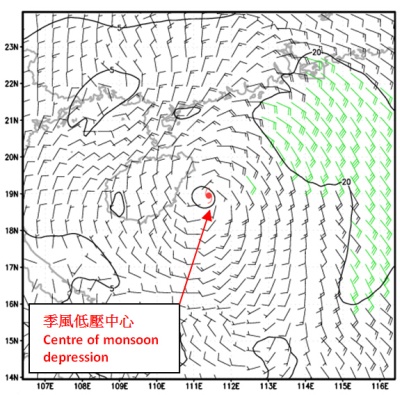
Figure 1Wind distribution of a typical monsoon depression (Source from National Oceanic
and Atmospheric Administration, U.S.A.), showing the region of strongest winds
(in green colour) located along the periphery of the monsoon depression.
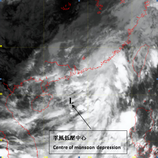
Figure 2Infrared satellite imagery at around 7:30 p.m. on 14th June 2013
(Source: Japan Meteorological Agency).
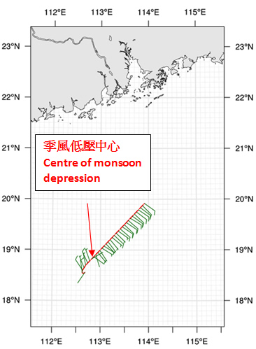
Figure 3Wind data at about 500 m from the surface collected by the fixed wing aircraft of Government
Flying Service at 2:00 to 2:30 p.m. on 14th June 2013. Red line indicates the flight path near the
centre of the low pressure system. Wind direction and wind speed are represented by the
wind barb symbols in green (all did not reach strong wind level).
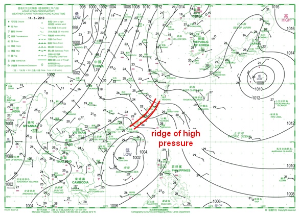
Figure 4Weather map at 8 a.m. on 14th June 2013, showing the low pressure area over
the South China Sea and the ridge of high pressure along southeastern China.
Monsoon depression originally refers to low pressure system affecting the North Indian Ocean and the Bay of Bengal in summer[1]. It encompasses a relatively large area and the diameter of closed isobar can be as wide as 1000 km. The region of strongest winds is usually located around the periphery of the low pressure area. Under the influence of surrounding weather systems, the high winds may occur in a particular quadrant of the monsoon depression (e.g. on the northeast quadrant, Figure 1) and may reach gale force[1][2]. On the other hand, the wind and convection near the core of a monsoon depression are relatively weak. The term 'monsoon depression' was later extended to describe other low pressure systems with similar characteristics in regions such as the South China Sea, Northwestern Pacific and Australia[2].
If convection persists and winds pick up near the centre of a monsoon depression, the system may develop into a tropical cyclone. One should note that not all monsoon depressions are under favourable conditions to develop into tropical cyclones. Without abundant moisture supply from the surroundings and with the presence of strong vertical wind shear (significant difference in wind direction and/or wind speed between upper and lower levels of the atmosphere), monsoon depressions are less likely to turn into tropical cyclones.
Meteorological services usually keep close watch on the evolution of a monsoon depression as it may develop into a tropical cyclone. In mid-June (14th and 15th June 2013), Hong Kong experienced rainy and windy weather under the influence of a monsoon depression over the South China Sea. Satellite imagery revealed that the low pressure area was loosely organized (Figure 2). There were no sustained convections around its centre that is typical of a tropical cyclone. With the assistance of the Government Flying Service, the Observatory acquired wind direction and speed data near the centre of the low pressure area in the afternoon of 14th June, revealing the absence of strong winds at around 500 m from the surface (Figure 3). As wind speed at this level is usually higher than that on the surface, the surface wind speed near the centre of the low pressure area thus had not reached strong force, not qualified for upgrading into a tropical depression(Note). In addition, surface observations available to the Observatory at that time also showed that there were no strong winds near the centre of the low pressure area. Yet a ridge of high pressure was located on the northern to northeastern periphery of the low pressure area (i.e. over southeastern China) (Figure 4). Under the combined effect of the low pressure area and the ridge of high pressure, winds over southeastern China (including Hong Kong) were windy, even reaching strong force from the east at times. The Observatory issued the Strong Monsoon Signal from the morning of 14th June to the next morning to warn the public of the strong easterlies in Hong Kong.
The above example shows that combined effect of a low pressure area and a high pressure system can bring strong winds to Hong Kong. Depending on the location and wind distribution of the monsoon depression, the wind affecting Hong Kong can come from the southeast. This is called the Southeast Monsoon[3]. In fact, in the absence of a high pressure system, the periphery of monsoon depression may still bring strong southeasterly winds to Hong Kong. In such circumstances, the Observatory may need to issue the Strong Monsoon Signal.
L.S. Lee, C.T. Shum
Note: The sustained surface (at 10 m height) wind speed near the centre of a low pressure area needs to reach strong force for classified as a tropical depression.
References:
[1] Monsoon meteorology, C.S. Ramage 1971.
[2] N.E. Davidson and G.J. Holland (1987): "A diagnostic Analysis of Two Intense Monsoon Depressions over Australia", Monthly Weather Review.
[3] C.C. Lam (2007). "The characteristics of the Southeast Monsoon in Hong Kong, Hong Kong Meteorological Society Bulletin Volume 17, 2007 http://www.meteorology.org.hk/bulletin/Vol17.1_2007.pdf, pp81 - 93."
Figure 1Wind distribution of a typical monsoon depression (Source from National Oceanic
and Atmospheric Administration, U.S.A.), showing the region of strongest winds
(in green colour) located along the periphery of the monsoon depression.
Figure 2Infrared satellite imagery at around 7:30 p.m. on 14th June 2013
(Source: Japan Meteorological Agency).
Figure 3Wind data at about 500 m from the surface collected by the fixed wing aircraft of Government
Flying Service at 2:00 to 2:30 p.m. on 14th June 2013. Red line indicates the flight path near the
centre of the low pressure system. Wind direction and wind speed are represented by the
wind barb symbols in green (all did not reach strong wind level).
Figure 4Weather map at 8 a.m. on 14th June 2013, showing the low pressure area over
the South China Sea and the ridge of high pressure along southeastern China.